
The Pacific Electric Railway Company, nicknamed the Red Cars, was a privately owned mass transit system in Southern California consisting of electrically powered streetcars, interurban cars, and buses and was the largest electric railway system in the world in the 1920s. Organized around the city centers of Los Angeles and San Bernardino, it connected cities in Los Angeles County, Orange County, San Bernardino County and Riverside County.

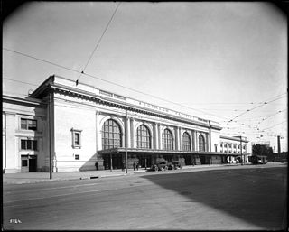
Los Angeles Union Station is the main train station in Los Angeles, California, and the largest passenger rail terminal in the Western United States. It opened in May 1939 as the Los Angeles Union Passenger Terminal, replacing La Grande Station and Central Station.

Castaic is an unincorporated community in the northwestern part of Los Angeles County, California, United States. As of the 2010 census it had a population of 19,015. For statistical purposes the Census Bureau has defined Castaic as a census-designated place (CDP).

Daggett is an unincorporated town located in San Bernardino County, California, in the United States. The town is located on Interstate 40, ten miles (16 km) east of Barstow, at an elevation of approximately 2,000 feet (610 m). The town has a population of about 200. The ZIP code is 92327 and the community is inside area code 760.

Lake Avenue is a major north–south feeder road for the Pasadena and Altadena communities in Los Angeles County, California. The road was developed in the mid 19th century and takes its name from a lake which was located at its southernmost end known variously as Mission Lake, Kewen Lake, and Wilson Lake reflecting different owners of the land. The lake bed still exists as a municipal park in the City of San Marino just south of the Raymond Dike, but it holds no water. It has been surrounded by residences who are served by a crisscross set of roads that dip into the edges of impression and back out the other side. Lake Avenue is approximately 5.06 miles (8.14 km) in length.
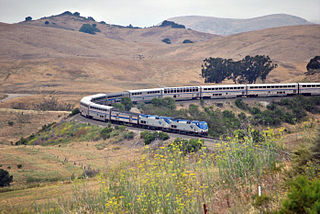
The Coast Line is a railroad line between Burbank, California and the San Francisco Bay Area, roughly along the Pacific Coast. It is the shortest rail route between Los Angeles and the Bay Area. Though not as busy as the Surf Line, the continuation of the Coast Line southbound to San Diego, it still sees freight movements and lots of passenger trains. The Pacific Surfliner, which runs from the San Diego Santa Fe Depot to San Luis Obispo via Union Station in Los Angeles, is the third busiest Amtrak route, and the busiest outside of the Northeast Corridor between Washington D.C. and Boston.

California's 29th congressional district is a congressional district in the U.S. state of California based in the north central San Fernando Valley. The district is represented by Democrat Tony Cárdenas.
California's 34th congressional district is a U.S. congressional district in California. Located in Los Angeles County, the district is represented by Democrat Jimmy Gomez. Its previous U.S. representative, Democrat Xavier Becerra of Los Angeles, resigned January 24, 2017, to become attorney general of California. Representative Gomez won a special election on June 6, 2017, beating fellow Democrat Robert Lee Ahn to replace Becerra. He was later sworn in as the district's U.S. representative on July 11, 2017.

The California Southern Railroad was a subsidiary railroad of the Atchison, Topeka and Santa Fe Railway in Southern California. It was organized July 10, 1880, and chartered on October 23, 1880, to build a rail connection between what has become the city of Barstow and San Diego, California.

Laws is an unincorporated community in Inyo County, California. Laws is located 4 miles (6.4 km) northeast of Bishop on U.S. Route 6, towards the Nevada state line.

The Los Angeles Terminal Railway, earlier known as the Pasadena Railway, and unofficially as the Altadena Railway, was a small terminal railroad line that was constructed between Altadena and Pasadena, California in the late 1880s. It was a byproduct of a land boom period and a victim of the land bust that occurred soon thereafter. It opened officially on January 31, 1888.

The Los Angeles and Salt Lake Railroad was a rail company in California, Nevada, and Utah in the United States, that completed and operated a railway line between its namesake cities, via Las Vegas, Nevada. Incorporated in Utah in 1901 as the San Pedro, Los Angeles and Salt Lake Railroad, the line was largely the brainchild of William Andrews Clark, a Montana mining baron and United States Senator. Clark enlisted the help of Utah's U.S. Senator Thomas Kearns, mining magnate and newspaper man, to ensure the success of the line through Utah. Construction of the railroad's main line was completed in 1905. Company shareholders adopted the LA&SL name in 1916. The railway was also known by its official nickname, "The Salt Lake Route", and was sometimes informally referred to as "The Clark Road". The tracks are still in use by the modern Union Pacific Railroad, as the Cima, Caliente, Sharp, and Lynndyl Subdivisions.
Alameda Street is a major north-south thoroughfare in Los Angeles County, California. It is approximately 21 miles in length, running from Harry Bridges Boulevard in Wilmington; and through Carson, Compton, Lynwood, Watts, Florence-Graham, Huntington Park, Vernon and Arts District to Spring and College in Chinatown. For much of its length, Alameda runs through present and former industrial corridors, and is paralleled by Union Pacific Railroad tracks.

Lamanda Park is a neighborhood in Pasadena, California. It is bordered roughly by Foothill Boulevard to the north, Del Mar Boulevard to the south, the Eaton Wash to the east, and Allen Avenue to the west, with a panhandle extending south along the western bank of the Eaton Wash. Like Annandale, it was originally a small township that was gradually enveloped by Pasadena. It was annexed in 1920. Even today, many commercial enterprises and newspapers still identify the area as a separate community.

Redondo Junction, California is the site of an Amtrak maintenance facility. It is located 3.5 miles (5.6 km) south of Los Angeles Union Station, southwest of Boyle Heights near Washington Boulevard and the Los Angeles River.
Central Station was the Southern Pacific Railroad's main passenger terminal in Los Angeles, California. It was formerly on Central Avenue at Fifth Street, in eastern Downtown Los Angeles. The primary hub for Southern Pacific's passenger operations in Southern California, it was served by the Sunset Limited, Coast Daylight, Golden State, and other named trains. The station replaced the company's previous Los Angeles terminal, Arcade Depot, and was often referred to by the name of the older facility.

Owensmouth was a town founded in 1912 in the western part of the San Fernando Valley in Los Angeles County, California. Owensmouth joined the city of Los Angeles in 1917, and was renamed Canoga Park on March 1, 1931. Owensmouth was named for the 1913 Owens River aqueduct's terminus in current Canoga Park.

Amoco Junction was a junction in the Pacific Electric Railway's Southern District. It was located in Nevin, South Central Los Angeles at 25th Street and Long Beach Avenue. It was named after a nearby American Olive Company (AmOCo) plant.
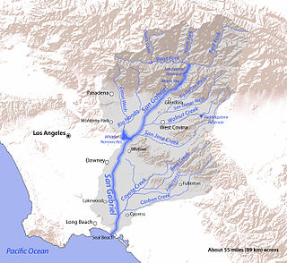
San Jose Creek is an intermittent, tributary stream of the San Gabriel River in Los Angeles County, California. The mouth of San Jose Creek is at an elevation of 194 feet at its confluence with the San Gabriel River, 3.5 miles (5.6 km) southwest of Bassett, California. Its source is at 960 feet near the Los Angeles County Fairplex, at 34°04′50″N117°45′38″W, where it has its confluence with Thompson Wash, actually a continuation of the creek into the San Gabriel Mountains. From Thompson Wash, San Jose Creek flows nearly 20 miles (32 km) westwards from Pomona into the San Gabriel River through the Pomona Valley and San Gabriel Valley. Because of its strategic location between the San Jose Hills and Puente Hills, the Union Pacific Railroad laid tracks along its route connecting Los Angeles with San Bernardino and Salt Lake City.

Riverside Depot is a former train station in Riverside, California.
