Related Research Articles

Brackish water is water having more salinity than freshwater, but not as much as seawater. It may result from mixing seawater with fresh water together, as in estuaries, or it may occur in brackish fossil aquifers. The word comes from the Middle Dutch root "brak". Certain human activities can produce brackish water, in particular civil engineering projects such as dikes and the flooding of coastal marshland to produce brackish water pools for freshwater prawn farming. Brackish water is also the primary waste product of the salinity gradient power process. Because brackish water is hostile to the growth of most terrestrial plant species, without appropriate management it is damaging to the environment.

An aquifer is an underground layer of water-bearing permeable rock, rock fractures or unconsolidated materials. Groundwater can be extracted using a water well. The study of water flow in aquifers and the characterization of aquifers is called hydrogeology. Related terms include aquitard, which is a bed of low permeability along an aquifer, and aquiclude, which is a solid, impermeable area underlying or overlying an aquifer, the pressure of which could create a confined aquifer.

The water table is the upper surface of the zone of saturation. The zone of saturation is where the pores and fractures of the ground are saturated with water.

Groundwater is the water present beneath Earth's surface in soil pore spaces and in the fractures of rock formations. A unit of rock or an unconsolidated deposit is called an aquifer when it can yield a usable quantity of water. The depth at which soil pore spaces or fractures and voids in rock become completely saturated with water is called the water table. Groundwater is recharged from the surface; it may discharge from the surface naturally at springs and seeps, and can form oases or wetlands. Groundwater is also often withdrawn for agricultural, municipal, and industrial use by constructing and operating extraction wells. The study of the distribution and movement of groundwater is hydrogeology, also called groundwater hydrology.

The San Joaquin River is the longest river of Central California in the United States. The 366-mile (589 km) long river starts in the high Sierra Nevada, and flows through the rich agricultural region of the northern San Joaquin Valley before reaching Suisun Bay, San Francisco Bay, and the Pacific Ocean. An important source of irrigation water as well as a wildlife corridor, the San Joaquin is among the most heavily dammed and diverted of California's rivers.
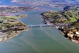
The Carquinez Strait is a narrow tidal strait in Northern California. It is part of the tidal estuary of the Sacramento and the San Joaquin rivers as they drain into the San Francisco Bay. The strait is eight miles (13 km) long and connects Suisun Bay, which receives the waters of the combined rivers, with San Pablo Bay, a northern extension of the San Francisco Bay.

The Sacramento–San Joaquin River Delta, or California Delta, is an expansive inland river delta and estuary in Northern California. The Delta is formed at the western edge of the Central Valley by the confluence of the Sacramento and San Joaquin rivers and lies just east of where the rivers enter Suisun Bay. The Delta is recognized for protection by the California Bays and Estuaries Policy. Sacramento–San Joaquin Delta was designated a National Heritage Area on March 12, 2019. The city of Stockton is located on the San Joaquin River on the eastern edge of the delta. The total area of the Delta, including both land and water, is about 1,100 square miles (2,800 km2). Its population is around 500,000 residents.
Saltwater intrusion is the movement of saline water into freshwater aquifers, which can lead to groundwater quality degradation, including drinking water sources, and other consequences. Saltwater intrusion can naturally occur in coastal aquifers, owing to the hydraulic connection between groundwater and seawater. Because saline water has a higher mineral content than freshwater, it is denser and has a higher water pressure. As a result, saltwater can push inland beneath the freshwater. Certain human activities, especially groundwater pumping from coastal freshwater wells, have increased saltwater intrusion in many coastal areas. Water extraction drops the level of fresh groundwater, reducing its water pressure and allowing saltwater to flow further inland. Other contributors to saltwater intrusion include navigation channels or agricultural and drainage channels, which provide conduits for saltwater to move inland. Sea level rise could also contribute to saltwater intrusion. Saltwater intrusion can also be worsened by extreme events like hurricane storm surges.

The delta smelt is an endangered slender-bodied smelt, about 5 to 7 cm long, in the family Osmeridae. Endemic to the upper Sacramento-San Joaquin Estuary of California, it mainly inhabits the freshwater-saltwater mixing zone of the estuary, except during its spawning season, when it migrates upstream to fresh water following winter "first flush" flow events. It functions as an indicator species for the overall health of the Delta's ecosystem.

Located in northern California the Suisun Marsh has been referred to as the largest brackish water marsh on west coast of the United States of America. The marsh land is part of the San Francisco Bay tidal estuary, and subject to tidal ebb and flood. The marsh is home to many species of birds and other wildlife, and is formed by the confluence of the Sacramento and San Joaquin rivers between Martinez and Suisun City, California and several other smaller, local watersheds. Adjacent to Suisun Bay, the marsh is immediately west of the legally defined Sacramento-San Joaquin Delta as well as part of the San Francisco Bay estuary.

The Pajaro River, is a U.S. river in the Central Coast region of California, forming part of the border between San Benito and Santa Clara Counties, the entire border between San Benito and Santa Cruz County, and the entire border between Santa Cruz and Monterey County. Flowing roughly east to west, the river empties into Monterey Bay, west of Watsonville, California.
Submarine groundwater discharge (SGD) is a hydrological process which commonly occurs in coastal areas. It is described as submarine inflow of fresh-, and brackish groundwater from land into the sea. Submarine Groundwater Discharge is controlled by several forcing mechanisms, which cause a hydraulic gradient between land and sea. Considering the different regional settings the discharge occurs either as (1) a focused flow along fractures in karst and rocky areas, (2) a dispersed flow in soft sediments, or (3) a recirculation of seawater within marine sediments. Submarine Groundwater Discharge plays an important role in coastal biogeochemical processes and hydrological cycles such as the formation of offshore plankton blooms, hydrological cycles, and the release of nutrients, trace elements and gases. It effects coastal ecosystems and has been used as freshwater resource by local communities for millennia.
Surficial aquifers are shallow aquifers typically less than 50 feet (15 m) thick, but larger surficial aquifers of about 60 feet (18 m) have been mapped. They mostly consist of unconsolidated sand enclosed by layers of limestone, sandstone or clay and the water is commonly extracted for urban use. The aquifers are replenished by streams and from precipitation and can vary in volume considerably as the water table fluctuates. Being shallow, they are susceptible to contamination by fuel spills, industrial discharge, landfills, and saltwater. Parts of southeastern United States are dependent on surficial aquifers for their water supplies.
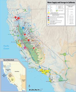
California's interconnected water system serves over 30 million people and irrigates over 5,680,000 acres (2,300,000 ha) of farmland. As the world's largest, most productive, and most controversial water system, it manages over 40 million acre feet (49 km3) of water per year.

The Jones Tract is an island containing Lower Jones Tract and the Upper Jones Tract in the Sacramento-San Joaquin River Delta in San Joaquin County, California, fifteen kilometres west of Stockton. The 4,900 ha island is bounded on the north by Empire Cut, on the northeast by Whiskey Slough, on the southeast by Trapper Slough, and on the west, Middle River. The tracts are bifurcated by the parallel running Mokelumne Aqueduct, West Lower Jones Road, and a railroad originally built by the Achison Topeka and Santa Fe Railroad, which now carries freight trains of the BNSF Railway and Amtrak California's San Joaquin.

In hydrology, a lens, also called freshwater lens or Ghyben-Herzberg lens, is a convex-shaped layer of fresh groundwater that floats above the denser saltwater, usually found on small coral or limestone islands and atolls. This aquifer of fresh water is recharged through precipitation that infiltrates the top layer of soil and percolates downwards until it reaches the saturated zone. The recharge rate of the lens can be summarized by the following equation:
Groundwater banking is a water management mechanism designed to increase water supply reliability. Groundwater can be created by using dewatered aquifer space to store water during the years when there is abundant rainfall. It can then be pumped and used during years that do not have a surplus of water. People can manage the use of groundwater to benefit society through the purchasing and selling of these groundwater rights. The surface water should be used first, and then the groundwater will be used when there is not enough surface water to meet demands. The groundwater will reduce the risk of relying on surface water and will maximize expected income. There are regulatory storage-type aquifer recovery and storage systems which when water is injected into it gives the right to withdraw the water later on. Groundwater banking has been implemented into semi-arid and arid southwestern United States because this is where there is the most need for extra water. The overall goal is to transfer water from low-value to high-value uses by bringing buyers and sellers together.

Coastal Erosion in Louisiana is the process of steady depletion of wetlands along the state's coastline in marshes, swamps, and barrier islands, particularly affecting the alluvial basin surrounding the mouth of the Mississippi River at the foot of the Gulf of Mexico on the Eastern half of the state's coast. In the last century, Southeast Louisiana has lost a large portion of its wetlands and is expected to lose more in the coming years, with some estimates claiming wetland losses equivalent to up to 1 football field per hour. One consequence of coastal erosion is an increased vulnerability to hurricane storm surges, which affects the New Orleans metropolitan area and other communities in the region. The state has outlined a comprehensive master plan for coastal restoration and has begun to implement various restoration projects such as fresh water diversions, but certain zones will have to be prioritized and targeted for restoration efforts, as it is unlikely that all depleted wetlands can be rehabilitated.

As a heavily populated state in the drought-prone arid west, water reuse in California—the use of reclaimed water for beneficial use—has developed as an integral part of water in California's story enabling both the economy and population to grow. Reclaimed water is treated wastewater that comes from homes and businesses, such as sink water, shower water, and even toilet water; this includes everything dumped down these wastewater drains from laundry soap to bleach to oil to human waste. Wastewater can divided into greywater and blackwater, with the first being defined as water that had been used for laundry, bathing, sink washing, and dishwaters. Blackwater, on the other hand, is defined as sewage that includes feces from toilets. Due to the low amounts of physical pollutants in greywater, most of its contaminants are dissolved organic matter, which can be physically filtered and cleaned through various membranes, as well as through biological treatment methods.

The Old River is a tidal distributary of the San Joaquin River that flows for about 40 miles (64 km) through the Sacramento–San Joaquin River Delta in Northern California. The Old River was once the main channel of the San Joaquin until navigation and flood control projects in the late 19th and 20th century fixed the San Joaquin to its present course past Stockton. It diverges from the San Joaquin near Tracy, about 38 miles (61 km) upstream from Antioch, and first runs west towards Mountain House, then north to rejoin the San Joaquin 13 miles (21 km) above Antioch. The river is lined with levees that prevent flooding of the adjacent Delta islands, many of which lie below sea level. The Middle River runs east of and roughly parallel to Old River. False River diverges from Old River about a mile (1.6 km) above the Old River's mouth and runs westward to join the San Joaquin at a point closer to Antioch. Part of the Old River forms the boundary between San Joaquin County on the east and Contra Costa County to the west.
References
- ↑ "Seawater intrusions in groundwater". Lenntech.
- ↑ Abd-Elaty, Ismail; Abd Elhamid, Hany Farhat; Javadi, Akbar (7 November 2016). "Numerical analysis of the effects of changing hydraulic parameters on saltwater intrusion in coastal aquifers". Engineering Computations. 33 (8): 2546–2564. doi:10.1108/EC-11-2015-0342. ProQuest 1830615685.
- ↑ Bray, Benjamin S.; Yeh, William W.-G. (1 March 2008). "Improving Seawater Barrier Operation with Simulation Optimization in Southern California". Journal of Water Resources Planning and Management. 134 (2): 171–180. doi:10.1061/(ASCE)0733-9496(2008)134:2(171).
- ↑ "Saltwater Intrusion in Los Angeles Area Coastal Aquifers--the Marine Connection - FS 030-02". pubs.usgs.gov.
- ↑ https://www.ocwd.com/media/2451/water-factory-21-brochure.pdf
- ↑ Survey, California Water Science Center, U.S. Geological. "Seawater Intrusion - SGMA - USGS CA Water Science Center". ca.water.usgs.gov.
- 1 2 Chenoweth, Jonathan (August 2008). "Water, water everywhere". New Scientist. 199 (2670): 28–32. doi:10.1016/S0262-4079(08)62124-7.
- 1 2 "Sacramento-San Joaquin Delta and Salinity". Water Education Foundation.
- ↑ "Suisun Marsh". Water Education Foundation.