The Lynchburg Metropolitan Statistical Area is a United States Metropolitan Statistical Area (MSA) in the state of Virginia, as defined by the Office of Management and Budget (OMB) as of June 2003. As of the 2000 census, the MSA had a population of 228,616. In 2009 this was estimated to have risen to 247,447; as of 2016, the Lynchburg MSA was estimated to have a population of 260,320, making it the fifth-largest metro area in the state.

The Jonesboro Metropolitan Statistical Area, as defined by the United States Census Bureau, is an area consisting of two counties – Craighead and Poinsett – in northeast Arkansas, anchored by the city of Jonesboro. As of the 2010 census, the MSA had a population of 121,026. It is also part of the larger Jonesboro-Paragould Combined Statistical Area.

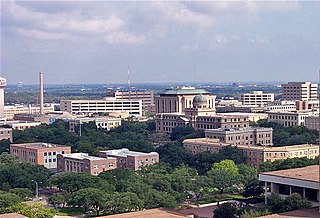
The Beaumont–Port Arthur metropolitan statistical area is defined by the United States Census Bureau as a three-county region in Southeast Texas. The metropolitan area shares borders with the Houston–The Woodlands–Sugar Land metropolitan area to the west and the Lake Charles metropolitan area in the U.S. state of Louisiana to the east. The area is also known as the Golden Triangle. The "golden" refers to the wealth that came from the Spindletop oil strike near Beaumont in 1901, and "triangle" refers to the area among the cities of Beaumont, Port Arthur, and Orange.

The Corpus Christi metropolitan statistical area is a metropolitan area in South Texas that covers three counties–Aransas, Nueces, and San Patricio. As of the 2000 census, the MSA had a population of 413,280.
College Station–Bryan is a metropolitan area centering on the twin cities of Bryan and College Station, Texas, in the Brazos Valley region of Texas. The 2010 census placed the population of the three county metropolitan area at 255,519. The 2019 population estimate was 273,101.

The Athens-Clarke County Metropolitan Statistical Area, as defined by the United States Census Bureau, is an area consisting of four counties - Clarke, Madison, Oconee, and Oglethorpe - in northeastern Georgia, anchored by the city of Athens. As of the 2020 census, the MSA had a population of 215,479.

The Parkersburg–Vienna metropolitan area, officially the Parkersburg–Vienna, WV Metropolitan Statistical Area as defined by the United States Census Bureau, is an area consisting of two counties in West Virginia, anchored by the cities of Parkersburg and Vienna. As of the 2020 census, the MSA had a population of 89,490. Prior to the 2020 census, the metro area included the city of Marietta, Ohio and Washington County, which has since been redefined as its own micropolitan area. They now form the Parkersburg–Marietta–Vienna, WV–OH Combined Statistical Area.

The Rockford Metropolitan Statistical Area, as defined by the United States Census Bureau, is an area consisting of four counties in north-central Illinois, anchored by the city of Rockford. As of the 2010 census, the MSA had a population of 349,431. The Rockford MSA abuts the southern portions of the Janesville-Beloit MSA and the Chicago MSA. It forms the main part of the larger Rockford–Freeport–Rochelle Combined Statistical Area.

The Victoria Metropolitan Statistical Area, as defined by the United States Census Bureau, is an area consisting of three counties in the Coastal Bend region of Texas, anchored by the city of Victoria. The area is sometimes referred to as the Golden Crescent Region, though this term is sometimes used to refer to a larger area than just these 3 counties. As of the 2000 census, the MSA had a population of 111,663.

As defined by the U.S. Office of Management and Budget and used by the U.S. Census Bureau for statistical purposes only, the Florence Metropolitan Statistical Area, is an area consisting of two counties in the Pee Dee region of northeastern South Carolina, anchored by the city of Florence. As of the 2000 census, the MSA had a population of 193,155.

The Paducah, KY–IL Metropolitan Statistical Area, as defined by the United States Census Bureau, is an area consisting of five counties – three in the Jackson Purchase region of Kentucky, a fourth Kentucky county bordering the Purchase, and one in Southern Illinois – anchored by the city of Paducah, Kentucky. The Paducah KY-IL Micropolitan Statistical Area was upgraded to Metropolitan Statistical Area (MSA) status on July 21, 2023, by the Office of Management and Budget.. Carlisle County, Kentucky, was added to the area following the 2020 Census of the Population. The total MSA population from the 2020 United States Census was 103,486.

The Aguadilla metropolitan area is a United States Census Bureau defined metropolitan statistical area (MSA) in northwestern Puerto Rico. According to the 2009 Census Bureau estimate, The area has the total population at 342,495, a 9.56% increase over the 2000 census figure of 312,602.
The Fajardo Metropolitan Statistical Area was a United States Census Bureau defined Metropolitan Statistical Area (MSA) in northeastern Puerto Rico. A July 1, 2009 Census Bureau estimate placed the population at 80,707, a 2.77% increase over the 2000 census figure of 78,533.
The Guayama Metropolitan Statistical Area is a United States Census Bureau defined Metropolitan Statistical Area (MSA) in southeastern Puerto Rico. As of the 2023 metropolitan area definitions, the Guayama metropolitan area has been included as a component of the San Juan–Bayamón, PR Combined Statistical Area. 2020 Census results placed the population at 68,442, an 18.73% decrease over the 2010 Census. 2010 Census results placed the population at 84,214, a 0.83% increase over the 2000 census figure of 83,570.
The Mayagüez Metropolitan Statistical Area is a United States Census Bureau defined Metropolitan Statistical Area (MSA) in west central Puerto Rico. A July 1, 2009 Census Bureau estimate placed the population at 109,842, a 4.53% decrease from the 2000 census figure of 115,048.

The San Juan metropolitan area is a United States Census Bureau defined metropolitan statistical area (MSA) in northeastern Puerto Rico centered around the city of San Juan. A July 1, 2009, Census Bureau estimate placed the population at 2,617,089, a 4.31% increase over the 2000 census figure of 2,509,007.
The San Germán–Cabo Rojo Metropolitan Statistical Area was a United States Census Bureau defined Metropolitan Statistical Area (MSA) in southwestern Puerto Rico. A July 1, 2009 Census Bureau estimate placed the population at 148,559, a 9.06% increase over the 2000 census figure of 136,212.

The Macon metropolitan area is a metropolitan statistical area consisting of five counties in Central Georgia, anchored by the principal city of Macon. At the 2010 U.S. census, the five-county area had a population of 232,293. A July 2017 estimate placed the population at 228,914. In 2022, its estimated population was 235,805.
The Kokomo Metropolitan Statistical Area, as defined by the United States Census Bureau, is an area consisting of Howard County in Indiana. Howard County had a population estimate of 83,831 in 2023. Kokomo is also the principal city of the area known as North Central Indiana, the area around Kokomo with economic ties. The six county area including Cass, Clinton, Fulton, Howard, Miami, and Tipton counties had population of 228,331 people in 2010.

The Hilton Head Island–Bluffton metropolitan area, officially the Hilton Head Island-Bluffton, SC Metropolitan Statistical Area as defined by the United States Census Bureau, is a metropolitan statistical area consisting of the two southernmost counties in the Lowcountry region of South Carolina, centered on the resort town of Hilton Head Island. As of the 2020 census, the MSA had a population of 215,908. Prior to March 2013, the region was considered a micropolitan statistical area.