
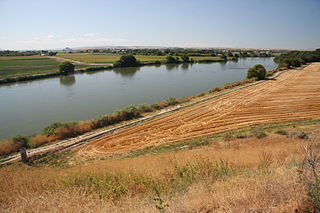
Santa Maria Valley is an American Viticultural Area (AVA) which straddles the boundary of Santa Barbara and San Luis Obispo counties in California's multi-county Central Coast AVA. It was established on August 5, 1981, by the Bureau of Alcohol, Tobacco, Firearms and Explosives (ATF) as California's second oldest AVA. A portion of the AVA crosses the Cuyama River into the southernmost corner of San Luis Obispo County. The east–west orientation of the 152.3 square miles with a wide, open valley and rolling hills means cool winds and fog flow in freely from the Pacific Ocean, settling most noticeably in lower-lying areas. The result is a mild Mediterranean climate that lengthens the growing season and contributes to the eventual sugar/acid balance in the grapes from Santa Maria Valley's 7,500 acres (3,000 ha) cultivated vineyards. On January 28, 2011, the AVA was granted an 29.4 square miles expansion to its southern boundary.

Paso Robles is the third American Viticultural Area (AVA) located in San Luis Obispo (SLO) County, California. It was established by the Bureau of Alcohol, Tobacco and Firearms (ATF), Treasury on November 3, 1983 based on a petition submitted by Martin Brothers Winery. The area encompasses 609,673 acres (953 sq mi) with approximately 18,500 acres (7,487 ha) cultivated with wine grapes known for their heritage varietal Zinfandel, Cabernet Sauvignon, and Rhône-style wines.

Central Coast is a vast American Viticultural Area (AVA) that spans along the Central California Pacific coastline from the San Francisco Bay Area south through Monterey, San Luis Obispo and Santa Barbara Counties. It was established on November 25, 1985 by the Bureau of Alcohol, Tobacco and Firearms (ATF), Treasury after reviewing the petition submitted by Taylor California Cellars, a winery in Gonzales, California, to establish the "Central Coast" viticultural area. The boundaries of the Central Coast, which have been expanded twice, includes portions of six counties where approximately 100,000 acres (40,469 ha) cultivated with Chardonnay being more than half of the varietal. Within the multi-county AVA are numerous established appellations that share the same maritime climate produced by the Pacific Ocean.
Arroyo Grande Valley is an American Viticultural Area (AVA) located in San Luis Obispo County, California approximately 12 miles (19 km) southeast of the county seat San Luis Obispo. Arroyo Grande Valley was recognized on February 5, 1990 by the Bureau of Alcohol, Tobacco, Firearms and Explosives (ATF) as the state's 60th AVA based on the petition filed in 1987 by Don Talley of Talley Vineyards and William S. Greenough of Saucelito Canyon Vineyard for the establishment of the "Arroyo Grande Valley" viticultural area in San Luis Obispo County. The 16 miles (26 km) long, approximately 67 square miles valley appellation benefits from its east-northeast orientation allowing the breeze from the Pacific Ocean to moderate the climate of the area. The valley is divided by a fog line produced by the cool maritime layer where Zinfandel, Petite Sirah and Rhône varietals are grown on the higher elevations near Lopez Lake and the cooler mid-valley vineyards being home to Chardonnay and Pinot noir. On April 8, 2022, the Alcohol and Tobacco Tax and Trade Bureau (TTB) approved the designation of the expansive San Luis Obispo (SLO) Coast AVA overlapping the boundaries of Edna Valley and Arroyo Grande Valley viticultural areas because they share common features. However, these two previously established areas still have unique characteristics to retain their viticultural area distinctions within SLO Coast. Edna Valley lies immediately to the northwest, the Los Padres National Forest straddles the north leg boundary, the Santa Maria Valley AVA lies to the southeast of Arroyo Grande Valley, and the Pacific Ocean communities of Oceano, Grover City and Arroyo Grande abut its southwestern border.

Edna Valley is an American Viticultural Area (AVA) located in San Luis Obispo (SLO) County, California encompassing the rural town of Edna which is 9 miles (14 km) southeast of the county seat San Luis Obispo and north of the small coastal town Arroyo Grande. It was established by the Bureau of Alcohol, Tobacco and Firearms (ATF) as the county's first AVA within California’s multi-county Central Coast AVA effective May 12, 1982. It became an sub-appellation of the county’s newest San Luis Obispo Coast viticultural area since April 2022. The valley is diagonally flanked by Lake Lopez to the south and Islay Hill to the north. The elongated valley extends along a northwest-southeast axis bordered to the west by the Santa Lucia Mountains and surrounded by volcanic mountains and characterized by black humus and clay-rich soils. With moderate sunshine, cool maritime fog, and rich oceanic and volcanic soils, the Edna Valley appellation has California's longest growing season. The valley is kept cool by breezes from the Pacific Ocean and morning fog. The extended growing season allows complex flavors to develop in the grapes.

California wine production has a rich viticulture history since 1680 when Spanish Jesuit missionaries planted Vitis vinifera vines native to the Mediterranean region in their established missions to produce wine for religious services. In the 1770s, Spanish missionaries continued the practice under the direction of the Father Junípero Serra who planted California's first vineyard at Mission San Juan Capistrano.
Adelaida District is an American Viticultural Area (AVA) located on the north west portion of the Paso Robles AVA in San Luis Obispo County, California. It was established by the Alcohol and Tobacco Tax and Trade Bureau (TTB) on November 10, 2014 after reviewing the petition submitted by The Paso Robles Viticultural Area Committee (PRVAC) to establish 11 new distinct viticultural areas located within the spacious Paso Robles AVA. The 59 wine industry members who constitute PRVAC cumulatively own or manage over 10,000 acres (4,047 ha) of cultivated vineyards within the proposed AVAs. Wineries located within the Adelaida District are: The Farm Winery, Peachy Canyon Winery, Le Cuvier, Alta Colina, Carmody McKnight Estate Wines, Wild Coyote, Villicana, McPrice Myers, Jacob Toft, Chronic Cellars, Vines on the Marycrest, Nenow Family Wines, Hawks Hill Ranch, Adelaida Cellars, DAOU, Calcareous, Law Estate, Nadeau, Minassian Young, Michael Gill, Villa Creek, Brecon, HammerSky, Oso Libre, Poallilo, Thacher Winery, Whalebone Vineyard, Tablas Creek Vineyard, Halter Ranch, Rangeland, Justin, Kukkula, Dubost, and Starr Ranch.
Creston District is an American Viticultural Area (AVA) located in the south east portion of the Paso Robles AVA in San Luis Obispo (SLO) County, California. It is located in the vicinity of the small community of Creston, California and was established by the Alcohol and Tobacco Tax and Trade Bureau (TTB) on November 10, 2014. The Paso Robles Viticultural Area Committee (PRVAC) petitioned TTB to establish 11 new AVAs located entirely within the existing Paso Robles viticultural area.

Talley Vineyards is a family-owned and operated California wine estate producing primarily Chardonnays and Pinot Noirs. The winery is located in Arroyo Grande Valley, near the town of Arroyo Grande in the southern corner of San Luis Obispo County. Talley farms 174 acres of wine grapes in six unique vineyards located in the Arroyo Grande Valley and Edna Valley AVAs. Talley Vineyards produces 30,000 cases annually.
Eagle Foothills is the second American Viticultural Area (AVA) in the state of Idaho located in the southwestern region in Gem and Ada Counties. The area lies southeast of Emmett, north of Eagle and approximately 10 miles (16 km) northwest of the city of Boise. It was established on December 28, 2015 by the Alcohol and Tobacco Tax and Trade Bureau (TTB), Treasury as the first sub-appellation in the vast Snake River Valley viticultural area and the first appellation entirely within Idaho’s state borders. It does not overlap with any existing or proposed AVA. Eagle Foothills lies at the north bank of Ancient Lake Idaho with its elevations ranging from 2,490 to 3,412 feet (759–1,040 m). The area encompasses 49,815 acres (78 sq mi) with nearly 70 acres (28 ha) under vine with plans to add 472 acres (191 ha) and seven vineyards. Its USDA plant hardiness zones are 7a and 7b. Vineyard elevations are below 3,000 feet (914 m). The majority of viticulture activity is at 3 Horse Ranch Vineyards with its 46 acres (19 ha) in center of the appellation. The cool climate and relatively short growing season are suitable for growing early to mid-season varietals such as Chardonnay, Pinot Gris and Riesling.
Squaw Valley-Miramonte is an American Viticultural Area (AVA) and a unique grape-growing region in Fresno County, California surrounding the towns of Squaw Valley and Miramonte approximately 40 miles (64 km) east of the city of Fresno. The AVA was established on August 7, 2015 by the U.S. Department of Treasury’s Alcohol and Tobacco Tax and Trade Bureau (TTB). It is largely a rural region located entirely within the foothills of the Sierra Nevada mountains and does not overlap any established AVAs. To the northwest, west, and south is the San Joaquin Valley while the Sequoia National Forest is adjacent to its northern and eastern boundaries. The scenic highway U.S. 180 bisects the region eastward from the Valley to the Big Trees in Kings Canyon and Sequoia National Parks. The AVA stretches over 44,690 acres (70 sq mi) with five commercially-producing vineyards cultivating about 7.5 acres (3.04 ha) and three bonded wineries. The USDA plant hardiness zone for the AVA is 9b.

Petaluma Gap is an American Viticultural Area (AVA) established on January 8, 2018 by the Alcohol and Tobacco Tax and Trade Bureau (TTB), Treasury. The area spans 202,476 acres (316 sq mi) stretching through an 30 miles (48 km) inland valley from the Pacific coast at Bodega Bay southeast to Highway 37 at Sears Point on San Pablo Bay straddling the border of northern Marin and southern Sonoma counties. The AVA lies entirely within the North Coast AVA and partially in the Sonoma Coast AVA with eighty commercially-producing vineyards cultivating 4,000 acres (1,619 ha) and nine bonded wineries. The wind gap in its coastal mountain range funnels cooling breezes and fog east from the Pacific Ocean through the city of Petaluma to San Pablo Bay. A persistent afternoon breeze causes lower grape yields and longer hang time contributes to the AVA vintages' unique flavors and fruit characteristics which defines their character and distinction.
Los Olivos District AVA is an American Viticultural Area located in Santa Barbara County, California established on January 20, 2016, by the Alcohol and Tobacco Tax and Trade Bureau (TTB). It straddles the Santa Ynez Valley, formed by the Santa Ynez River, between the Purisima Hills above Solvang. The area encompasses the townships of Los Olivos, Ballard, Santa Ynez and Solvang. State Route 154, known locally as the San Marcos Pass Road or Chumash Highway, bisects the region accessing many of the wineries and vineyards as it traverses toward its destination in Santa Barbara.
Moon Mountain District Sonoma County is an American Viticultural Area (AVA) within Sonoma Valley and North Coast viticultural areas, just north of the city of Sonoma. This mountainous region on the very eastern edge of Sonoma County has a historic reputation for producing rich, intensely-flavored wines from Cabernet Sauvignon and Syrah varietals since the 1880s. The District was established on November 1, 2013, by the Alcohol and Tobacco Tax and Trade Bureau (TTB). Its designation covers 17,663 acres (28 sq mi) of land stretching north-south along the western slopes of the Mayacamas mountains between Sugarloaf Ridge State Park and Los Carneros viticultural area with the Napa Valley’s Mount Veeder viticultural area outlining the eastern slopes. Its name is derived from Moon Mountain Road, which traverses through the area and itself a reference to Sonoma, which means 'valley of the moon' in the local Native American dialect. A clear view to San Francisco 50 miles (80 km) south is not uncommon from Moon Mountain District vineyards.
Alisos Canyon is an American Viticultural Area (AVA), located in Santa Barbara County, California due east outside the small town of Los Alamos on U.S 101 and about 20 miles (32 km) south of Santa Maria, was established on August 25, 2020, by the Alcohol and Tobacco Tax and Trade Bureau (TTB). Alisos Canyon stretches west to east over 9 square miles with one bonded winery and nine commercially-producing vineyards cultivates on approximately 238 acres (96 ha). Alisos Canyon Road bisects the region accessing many of its vineyards. The USDA plant hardiness zone for the AVA is 7b.

Santa Barbara County wine is an appellation that designates wine made from grapes grown mostly in Santa Barbara County, California which is located approximately 50 miles (80 km) north of Los Angeles County. County names in the United States automatically qualify as legal appellations of origin for wine produced from grapes grown in that county and do not require registration with the Alcohol and Tobacco Tax and Trade Bureau (TTB) of the Treasury Department. TTB was created in January 2003, when the Bureau of Alcohol, Tobacco and Firearms, or ATF, was extensively reorganized under the provisions of the Homeland Security Act of 2002.

San Luis Obispo (SLO) County wine is a appellation that designates wine made from grapes grown in San Luis Obispo (SLO) County, California which is sandwiched between Santa Barbara County to the south and Monterey County at the northern boundary on the Pacific coast. Its location sits halfway between the cities of San Francisco and Los Angeles on the north–south axis of U.S. Route 101 and Pacific Coast Highway (PCH). The county lies entirely within the Central Coast viticultural area. County names in the United States automatically qualify as legal appellations of origin for wine produced from grapes grown in that county and do not require registration with the Alcohol and Tobacco Tax and Trade Bureau (TTB) of the Treasury Department. TTB was created in January of 2003, when the Bureau of Alcohol, Tobacco and Firearms, or ATF, was extensively reorganized under the provisions of the Homeland Security Act of 2002.

Monterey County wine is a appellation that designates wine made from grapes grown in Monterey County, California which lies entirely within the expansive multi-county Central Coast viticultural area. County names in the United States automatically qualify as legal appellations of origin for wine produced from grapes grown in that county and do not require registration with the Alcohol and Tobacco Tax and Trade Bureau (TTB). TTB was created in January 2003, when the Bureau of Alcohol, Tobacco and Firearms, or ATF, was extensively reorganized under the provisions of the Homeland Security Act of 2002.

Goose Gap is the 19th American Viticultural Area (AVA) in Washington, United States. It encompasses the local region surrounding Goose Mountain in Benton County between Kiona to the west, and Richland along the Columbia River to the east. The viticultural area was formally established on August 2, 2021, by the Alcohol and Tobacco Tax and Trade Bureau (TTB), Treasury after reviewing the petition submitted by geologist/vintner, Alan Busacca, on behalf of the Goose Gap Wine Grower's Association, proposing the viticultural area "Goose Gap". The area is a sub-appellation entirely within the Yakima Valley and the expansive Columbia Valley AVAs sandwiched on a northwest–southeast axis between neighboring viticultural areas Red Mountain and the minute Candy Mountain.
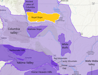
Royal Slope is an American Viticultural Area (AVA) located within Adams and Grant Counties in central Washington state. Royal Slope is the state's 15th appellation recognized by the Alcohol and Tobacco Tax and Trade Bureau {TTB), Treasury on October 2, 2020, after reviewing the petition submitted by Alan Busacca, a licensed geologist and founder of Vinitas Vineyard Consultants, LLC, on behalf of the Royal Slope Wine Grower's Association, proposing the viticultural area named “Royal Slope.” The AVA lies between the Quincy Basin and Saddle Mountains surrounding the town of Royal City encompassing 156,389 acres (244 sq mi) entirely within the vast Columbia Valley AVA. There are currently 13 producing commercial vineyards cultivating approximately 14,100 acres (5,706 ha) with only one winery. According to the petition, the distinguishing features of the Royal Slope AVA are its climate, topography, geology, and soils.
