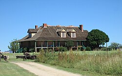
Rancho Petaluma Adobe is a historic ranch house in Sonoma County, California. It was built from adobe bricks in 1836 by order of Mariano Guadalupe Vallejo. It was the largest privately owned adobe structure built in California and is the largest example of the Monterey Colonial style of architecture in the United States. A section of the former ranch has been preserved by the Petaluma Adobe State Historic Park and it is both a California Historic Landmark and a National Historic Landmark. The Rancho Petaluma Adobe State Historic Park is located on Adobe Road on the east side of the present-day town of Petaluma, California.

Mission San Cayetano de Calabazas, also known as Calabasas, is a Spanish Mission in the Sonoran Desert, located near present-day Tumacacori, Arizona, United States.

San Bernardino Ranch is a historic ranch house in the southern San Bernardino Valley near the San Bernardino National Wildlife Refuge in extreme southeast Cochise County, Arizona, United States. It is significant for its association with the beginning of cattle ranching in southern Arizona and northern Mexico. The ranchland and valley are part of the headwaters region of the Yaqui River.
The Sierra Bonita Ranch, founded in 1872 by Henry C. Hooker, is one of the oldest cattle ranches in the United States and the ranch buildings have been designated a National Historic Landmark. It was the first permanent American cattle ranch in Arizona. Hooker bought neighboring ranches until his operation became the largest ranch in Arizona, totaling 800 square miles (2,100 km2), or about 30 by 27 miles. It is located in Sulphur Springs Valley about 27 miles (43 km) north of present-day Willcox, Arizona. The modern ranch is much smaller but is still operational and owned by Jesse Hooker Davis, the sixth generation to live and work on the ranch.
Hereford is a populated place in Cochise County along the San Pedro Riparian National Conservation Area in the southern part of the U.S. state of Arizona. It is southeast of Sierra Vista and is a part of the Sierra Vista-Douglas micropolitan area. The elevation is 4,193 feet at the location of the original townsite at the far eastern end of the unincorporated area; the residential area runs for another 8 miles west from this location, blending into the unincorporated area of Nicksville at an elevation of approximately 4800 feet. Hereford Station Post Office is located at the far western end of Nicksville, at the foot of the Huachuca Mountains.
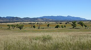
The San Rafael Valley is a high intermontane grass valley in eastern Santa Cruz County, Arizona. The valley is bounded to the west by the Patagonia Mountains, to the north and northeast by the Canelo Hills and to the east by the Huachuca Mountains in Cochise County. The valley forms the headwaters of the Santa Cruz River which flows south into Sonora, Mexico just east of the historic Lochiel townsite.
Warner's Ranch, near Warner Springs, California, was notable as a way station for large numbers of emigrants on the Southern Emigrant Trail from 1849 to 1861, as it was a stop on both the Gila River Trail and the Butterfield Overland Mail stagecoach line (1859-1861). It was also operated as a pioneering cattle ranch.

The 4 Lazy F Ranch, also known as the Sun Star Ranch, is a dude ranch and summer residence in Jackson Hole, Wyoming, built by the William Frew family of Pittsburgh in 1927. The existing property was built as a family retreat, not as a cattle ranch, in a rustic style of construction using logs and board-and-batten techniques. The historic district includes seven cabins, a lodge, barn corral and smaller buildings on the west bank of the Snake River north of Moose, Wyoming. The property was added to the National Register of Historic Places in 1990.

The Faraway Ranch Historic District is part of the Chiricahua National Monument in southeastern Arizona, and preserves an area associated with the final conflicts with the local Apache, one of the last frontier settlements, and in particular, its association with the people who promoted the establishment of the Chiricahua National Monument. Faraway Ranch is located in Bonita Canyon, which lies at an approximate altitude of 5160 feet and opens in a southwesterly direction into the Sulphur Springs Valley.
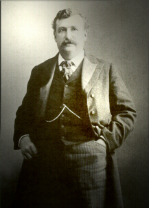
Colonel William Cornell Greene was an American businessman who was famous for discovering rich copper reserves in Cananea, Mexico, and for founding the Greene Consolidated Copper Company in 1899. By 1905, Greene was one of the wealthiest businessmen in the world.

The James Cant Ranch is a pioneer ranch complex in Grant County in eastern Oregon, United States. The ranch is located on both sides of the John Day River in the John Day Fossil Beds National Monument. The ranch was originally homesteaded by Floyd Officer in 1890. Officer sold the property to James Cant in 1910. Cant increased the size of the property and built a modern ranch complex on the west bank of the river. The National Park Service bought the ranch from the Cant family in 1975, and incorporated the property into the John Day Fossil Beds National Monument. The National Park Service used the main house as a visitor center until 2003. Today, the Cant Ranch complex is preserved as an interpretive site showing visitors an early 20th-century livestock ranch. The James Cant Ranch is listed on the National Register of Historic Places.
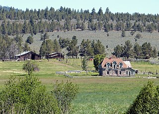
The Diamond Ranch was established near Chugwater, Wyoming in 1878 by George Rainsford, a New York native who came west to breed horses. Rainsford, an architect, designed many of the structures at the ranch. Horses bred at the ranch, mainly Morgans and Clydesdales, were widely known and sought after. The ranch was named after Rainsford's Diamond brand, one of the two oldest registered brands in Wyoming. Unlike most brands, which remain with the owner, the Diamond brand has remained with the property. The ranch features extensive barns for breeding and raising horses, as well as a more modest ranch house. In its prime there were formal gardens.

Lochiel is a populated place and former border crossing in southern Santa Cruz County, Arizona, United States, approximately 25 miles east of Nogales. Basically a ghost town, the townsite is located in the southwestern part of the San Rafael Valley on Washington Gulch, about 1.5 miles west of the Santa Cruz River. It was first settled in the late-1870s and mostly abandoned by 1986. The town served the ranches of the San Rafael Valley and the Washington Camp and Duquesne mining towns of the Patagonia Mountains, approximately five miles to the northwest up Washington Gulch.
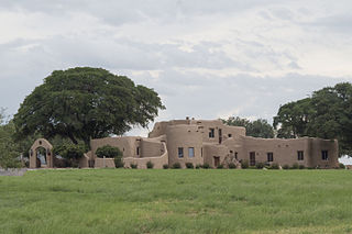
Kinjockity Ranch, also known as Lanteen Ranch, is a Pueblo Revival style residence in Cochise County, Arizona, originally built in 1939-1940 for Rufus Riddlesbarger, a wealthy Chicago businessman. It is a notable example of Pueblo Revival style, executed in adobe with richly detailed interiors and hand-made hardware. The house was designed by Edward C. Morgan, an architect from Phoenix who specialized in what he called "the Mexican style." The interiors were decorated and embellished by illustrator and sculptor Raymond Phillips Sanderson, who had collaborated with Morgan on previous commissions.
The Roba Ranch is a pioneer ranch located near the small unincorporated community of Paulina in Crook County, Oregon. The ranch is named for George and Mary Roba, sheep ranchers who acquired the property in 1892. Most of the important ranch buildings were constructed by the Roba family between about 1892 and 1910. Today, the ranch covers 1,480 acres (6.0 km2) and is privately owned. The ranch was listed on the National Register of Historic Places in 2007.

Brown Canyon Ranch, formerly known as the Barchas Ranch, is a historic ranch located in the foothills of the Huachuca Mountains, near Sierra Vista, Arizona.

The Little Boquillas Ranch is an historic ranch property located in western Cochise County, Arizona, near the Fairbank Historic Townsite in what is now part of the San Pedro Riparian National Conservation Area.

The Colter Ranch Historic District consists of twelve buildings in a rural setting near Eagar, Arizona. The site is located in the Amity Valley, which itself is part of Round Valley ; the Little Colorado River runs along the one side of the district. Most of the buildings date from between 1904 and 1930, the period during which Fred Colter resided on the residence.

Eagar Townsite Historic District is a section of the town of Eagar, Arizona which has been designated a National Historic Place. Sitting on roughly 54 acres, the site contains 37 structures, 21 of which have historical significance. The period of significance is from 1886, the year the townsite was founded, through 1942, which represents the significant period of development of the town. The site was added to the Register on July 23, 1993.
The Schilling Ranch Historic District is a tiny portion of a historic ranch in Cochise County, Arizona which was listed on the National Register of Historic Places in 2009. It consists of several structures built in the early to mid-1900s. It is representative of the infrastructure required by cattle ranching operations in the Southwestern United States. It was used as a central location for cattle roundups from the surrounding cattle ranches, before shipment to the Willcox cattle auctions.