San Salvador Island

Last updated
San Salvador Island
Guanahaní
Watling's Island
Island and District
SanSalvador map.jpg
A map of San Salvador Island
Bahamas location map.svg
Red pog.svg
San Salvador Island
Coordinates: 24°06′N74°29′W / 24.100°N 74.483°W / 24.100; -74.483
Country Bahamas
Island San Salvador
District San Salvador
Area
  Total163 km2 (63 sq mi)
Population
 (2022)
  Total824 [1]
Time zone UTC−5 (Eastern Time Zone)
Area code 242

San Salvador Island, previously Watling's Island, is an island and district of the Bahamas, famed for being the probable location of Christopher Columbus's first landing of the Americas on 12 October 1492 during his first voyage. This historical importance, the island's tropical beaches, and its proximity to the United States have made tourism central to the local economy. The island has a population of 824 (2022) and is under the administration of Gilbert C. Kemp. Its largest settlement and seat of local government is Cockburn Town.

Contents

Names

Watling's Island was named for George or John Watling, an Englishman who settled it in the 17th century. The name was used officially from the 1680s [2] until 1926. It is still used unofficially in discussions of the actual location of Columbus's first landfall.

San Salvador derives from the Spanish Isla San Salvador ("Island of the Holy Savior"), bestowed by Christopher Columbus in honor of Jesus Christ in thanks for his fleet's safe arrival [3] in what he thought was East Asia. Columbus recorded the native's name for the place as Guanaham, [3] now considered to be a mistranscription of Taíno Guanahaní , meaning "Small Land in the Upper Waters". [4]

Geography

The Antilles Current Antilles current.jpg
The Antilles Current

San Salvador Island sits on its own isolated carbonate platform surrounded by a narrow shelf that reaches a depth of up to 40 meters (130 ft). [5] [6] Past the shelf, the slope becomes almost vertical and depth quickly increases to 4,000 meters (13,000 ft). [5] [7] San Salvador Island experiences a semidiurnal tide, with two high tides and two low tides per day. [8] Water temperature in San Salvador can range from 23 to 29 °C (73 to 84 °F) depending on the location and time of year. Salinity and dissolved oxygen are consistent throughout the island and throughout the year (35 ppt and 6.0% respectively). [7]

Most of San Salvador Island is surrounded by fringing reefs. [7] In many areas, such as Fernandez Bay, the shore is rocky and populated by reef urchins (Echinometra viridis). Moving away from shore, the bottom slopes gradually and may have several patch reefs surrounded by a sandy bottom. These patch reefs are home to hundreds of fish, invertebrates, and algae. [7] The depth continues to increase to about 25 meters (82 ft) at the farthest edge of the shelf, which can be 400 to 1,500 meters (1,300 to 4,900 ft) from shore. [7]

Wind and wave action in San Salvador is influenced by the Antilles Current. The Antilles Current originates south of the Bahamas, Puerto Rico, and Cuba and moves northward where it merges with the Gulf Stream. [9] [10] This current cools the waters around San Salvador in the summer and warms the water around the island in the winter. This keeps the water temperature relatively mild and consistent throughout the year. [7]

The coasts of San Salvador are very different from each other. The west coast of San Salvador faces the rest of the Bahamas and the Great Bahama Bank. Most of these islands are sheltered from significant winds and wave action, making the water generally calmer with greater visibility. In contrast, the eastern coast of San Salvador is windward and completely exposed to the rest of the Atlantic Ocean and is not protected by any other geological formations. [6]

As a result, wave action is much stronger and visibility is lower. Evidence of currents from the Atlantic Ocean can be found on the east coast in the form of trash and debris on the beaches. During Hurricane Joaquin in October 2015, cargo steamer El Faro went down approximately 50 miles east of San Salvador. Several weeks later, pieces of the containers that had been swept away by the current were reported on the beaches of San Salvador. [11]

History

San Salvador from space (2007) San Salvador, Bahamas.jpg
San Salvador from space (2007)

Columbus's arrival

Christopher Columbus's voyages west were sponsored by Spain in the hopes that he would reach China and the East Indies, circumventing both Turkish and Portuguese control of the eastern and southern routes of the lucrative spice trade. [12] Letters from Columbus to the Spanish monarchs Isabella I of Castile and Ferdinand II of Aragon record that the first island sighted during his first voyage was known to its Lucayan inhabitants as Guanahaní and that he renamed it San Salvador in thanks to God. [3] [13]

Arriving on 12 October 1492, he described the Lucayans as "sweet and gentle", [14] "naked as they were born", [15] possessed of "neither iron, nor steel, nor arms, nor... competent to use them", [16] "timid to a surprising degree", [16] andcombined with the other islands he visitedwould enable to him to deliver to Spain "slaves, as many of these idolators as their Highnesses shall command to be shipped". [17] Earlier in the same letter, Columbus had explained that the Lucayans were not idolators [18] butas chattel slavery had largely disappeared from Europe during the High Middle Ages and Early Renaissance its revival under Nicholas V's 1452 Dum Diversas... and similar bulls were dependent on the idolatrous status of the enslaved. [19]

Columbus himself seized several Guanahamians by force to use as translators and ambassadors, [20] despite forcing his crew to stop cheating them in exchanges of random trash for items of great worth, [21] including one who received 12 g of gold for a used leather strap. [22] Despite their general intelligence, [21] the Guanahamian slaves considered him sent from the heavens and secured him welcome at every island he visited. [20]

The location of this first island visited by Columbus is disputed. In the 19th century, it was usually thought to be Cat Island [23] but arguments from Juan Bautista Muñoz; [24] Captain Alexander B. Becher, [25] a hydrographer in the Royal Navy; Rear Adm. Joseph B. Murdock of the U.S. Navy; [26] Richard Henry Major, [27] map custodian of the British Museum; the geographer Clements Markham; [28] the naval historian Samuel E. Morison; and the Benedictine priest Chrysostom Schreiner eventually led to the island's 1926 renaming. Fr. Schreiner relocated to San Salvador, where his tomb is still preserved. [23] More recently, the National Geographic Society, Keith Pickering, [29] and others have argued for alternative locations, including Samana Cay. [30]

Later history

The USCG LORAN Station San Salvador under construction in the late 1950s USCG LORAN Station San Salvador.jpg
The USCG LORAN Station San Salvador under construction in the late 1950s

The island now called San Salvador was settled in the 17th century by the English buccaneer George or John Watling. Britain formally colonized the Bahamas in the early 18th century.

During the Cold War, the United States Navy's Mobile Construction Battalion 7 constructed a long-range navigation (LORAN) station on Grahams Harbor at the north end of the island from 1957 to 1959. [31] After the LORAN station was decommissioned, it became the Bahamian Field Station and then the Gerace Research Center. [32] More than 1,000 students and researchers work from the station every year as a base of operations for studying tropical marine geology, biology, and archeology.

San Salvador has required extensive rebuilding following Hurricane Lili in 1996, [33] Hurricane Floyd in 1999, [34] and Hurricane Joaquin in 2015. [35] Floyd in particular caused considerable beach erosion. [34]

Tourism

Tourism is the island's main industry, thanks to its historical importance, many sandy beaches, and proximity to the United States. It is served by San Salvador International Airport. Columbus Isle, a Club Med resort, is located just north of the main settlement at Cockburn Town.

The island is home to many shallow-water coral reefs, where snorkellers can observe hundreds of fish species without the use of scuba equipment. The Pleistocene Cockburn Town Fossil Reef is near the main town and resort. [36] Fossilized staghorn coral ( Acropora cervicornis ) and elkhorn coral ( Acropora palmata ) are present near the crest of the fossil reef and other corals such as Montastraea annularis , Diploria , and Porites are scattered in the periphery. San Salvador is also known for the quick dropoff of the submerged platform of the island, allowing for numerous deep dive sites. The western coast has many wall reefs with steep drop offs, while the northern coast has many shallow barrier reefs, particularly surrounding the large shallow lagoon of Grahams Harbor.

The Dixon Hill lighthouse is located on the island south of Dixon Hill Settlement on the east side of the island. It is approximately 160 feet (49 m) tall and was constructed in 1887 by the Imperial Lighthouse Service. [37]

There are also several monuments, ruins, and shipwrecks in the area. [38] [39]

Government

The seat of local government is Cockburn Town, with a population of 271 (2010). [40] The current administrator is Gilbert C. Kemp.[ citation needed ]

Related Research Articles

<span class="mw-page-title-main">The Bahamas</span> Country in North America

The Bahamas, officially the Commonwealth of The Bahamas, is an island country within the Lucayan Archipelago of the West Indies in the Atlantic Ocean. It contains 97% of the Lucayan Archipelago's land area and 88% of its population. The archipelagic state consists of more than 3,000 islands, cays, and islets in the Atlantic Ocean, and is located north of Cuba and northwest of the island of Hispaniola and the Turks and Caicos Islands, southeast of the U.S. state of Florida, and east of the Florida Keys. The capital is Nassau on the island of New Providence. The Royal Bahamas Defence Force describes The Bahamas' territory as encompassing 470,000 km2 (180,000 sq mi) of ocean space.

<span class="mw-page-title-main">History of the Bahamas</span>

The earliest arrival of people in the islands now known as The Bahamas was in the first millennium AD. The first inhabitants of the islands were the Lucayans, an Arawakan language-speaking Taino people, who arrived between about 500 and 800 AD from other islands of the Caribbean.

The Lucayan people were the original residents of The Bahamas before the European conquest of the Americas. They were a branch of the Taínos who inhabited most of the Caribbean islands at the time. The Lucayans were the first indigenous Americans encountered by Christopher Columbus. Shortly after contact, the Spanish kidnapped and enslaved Lucayans, with the displacement culminating in the complete eradication of the Lucayan people from the Bahamas by 1520.

<span class="mw-page-title-main">Andros, Bahamas</span> Archipelago of The Bahamas

Andros Island is an archipelago within The Bahamas, the largest of the Bahamian Islands. Politically considered a single island, Andros in total has an area greater than all the other 700 Bahamian islands combined. The land area of Andros consists of hundreds of small islets and cays connected by mangrove estuaries and tidal swamplands, together with three major islands: North Andros, Mangrove Cay, and South Andros. The three main islands are separated by bights, estuaries that trifurcate the island from east to west. It is 167 kilometres (104 mi) long by 64 km (40 mi) wide at the widest point.

<span class="mw-page-title-main">Cay</span> Small island formed on the surface of a coral reef

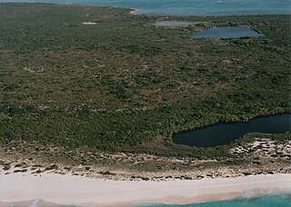
A cay, also spelled caye or key, is a small, low-elevation, sandy island on the surface of a coral reef. Cays occur in tropical environments throughout the Pacific, Atlantic, and Indian oceans, including in the Caribbean and on the Great Barrier Reef and Belize Barrier Reef.

<span class="mw-page-title-main">Grand Turk Island</span> Island in the Turks and Caicos Islands

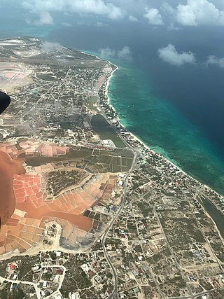
Grand Turk is an island in the Turks and Caicos Islands, a British Overseas Territory, tropical islands in the Lucayan Archipelago of the Atlantic Ocean and northern West Indies. It is the largest island in the Turks Islands with 18 km2 (6.9 sq mi). Grand Turk contains the territory's capital, Cockburn Town, and the JAGS McCartney International Airport. The island is the administrative, historic, cultural and financial centre of the territory and has the second-largest population of the islands at approximately 4,831 people in 2012.

<span class="mw-page-title-main">Abaco Islands</span> Group of islands in the Bahamas

The Abaco Islands lie in the northern Bahamas, located about 193 miles east of Miami, Florida. The main islands are Great Abaco and Little Abaco, which is located just west of the northern tip of Great Abaco. There are several smaller barrier cays, of which the northernmost are Walker's Cay and its sister island Grand Cay. To the south, the next inhabited islands are Spanish Cay and Green Turtle Cay, with its settlement of New Plymouth, Great Guana Cay, private Scotland Cay, Man-O-War Cay, and Elbow Cay, with its settlement of Hope Town. Southernmost are Tilloo Cay and Lubbers Quarters. Another of note off Abaco's western shore is Gorda Cay, now a Disney-owned island and a cruise ship stop renamed Castaway Cay. Also in the vicinity is Moore's Island. On the Big Island of Abaco is Marsh Harbour, the Abacos' commercial hub and the Bahamas' third largest city, plus the resort area of Treasure Cay. Both have airports. A few mainland settlements of significance are Coopers Town and Fox Town in the north and Cherokee and Sandy Point in the south. Administratively, the Abaco Islands constitute seven of the 31 Local Government Districts of the Bahamas: Grand Cay, North Abaco, Green Turtle Cay, Central Abaco, South Abaco, Moore's Island, and Hope Town.

<span class="mw-page-title-main">Freeport, Bahamas</span> City in Grand Bahama, The Bahamas

Freeport is a city, district and free trade zone on the island of Grand Bahama of the northwest Bahamas. In 1955, Wallace Groves, a Virginian financier with lumber interests in Grand Bahama, was granted 20,000 hectares of pineyard with substantial areas of swamp and scrubland by the Bahamian government with a mandate to economically develop the area. Freeport has grown to become the second most populous city in the Bahamas.

<span class="mw-page-title-main">Rum Cay</span> Place in Bahamas

Rum Cay is an island and district of the Bahamas. It measures 30 square miles (78 km2) in area, it is located at Lat.: N23 42' 30" - Long.: W 74 50' 00". It has many rolling hills that rise to about 120 feet.

<span class="mw-page-title-main">Guanahani</span> Island in the Bahamas which Christopher Columbus landed on

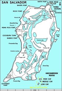
Guanahaní was the Taíno name of an island in the Bahamas that was the first land in the New World sighted and visited by Christopher Columbus' first voyage, on 12 October 1492. It is a bean-shaped island that Columbus called San Salvador. Guanahaní has traditionally been identified with Watlings Island, which was officially renamed San Salvador Island in 1925 as a result, but modern scholars are divided on the accuracy of this identification and several alternative candidates in and around the southern Bahamas have been proposed as well.

<span class="mw-page-title-main">Plana Cays</span>

The Plana Cays are a group of two small uninhabited islands in the southern Bahama Islands, located east of Acklins Island and west of Mayaguana Island. The indigenous Lucayan people called the islands Amaguaya, meaning "toward the middle lands".

<span class="mw-page-title-main">1921 Atlantic hurricane season</span> Hurricane season in the Atlantic Ocean

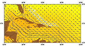
The 1921 Atlantic hurricane season was an active hurricane season, with 12 tropical cyclones forming. Among them, seven became tropical storms, of which five strengthened into hurricanes. Furthermore, two of these strengthened into a major hurricane, Category 3 or higher on the modern-day Saffir–Simpson hurricane wind scale, the most since the 1917 season. The first system, a tropical depression, developed on June 1, while the last, a tropical storm, dissipated on November 25. Of note, three tropical cyclones co-existed with another during the season.

<span class="mw-page-title-main">Samana Cay</span>

Samana Cay is a now uninhabited island in the Bahamas believed by some researchers to have been the location of Christopher Columbus's first landfall in the Americas on October 12, 1492.

<span class="mw-page-title-main">South Caicos</span> Island in the Turks and Caicos Islands

South Caicos is the seventh-largest island in the Turks and Caicos archipelago, with a land area of 21.2 square kilometres. South Caicos is known for excellent fishing, both deep-sea and bone fishing, and scuba diving. South Caicos was formerly a salt exporter, the island still hosts a network of salt pans as a reminder of the industry. Today, the island's main income is derived from small-scale commercial fishing.

John, or George, Watling was a 17th-century English buccaneer. It was said that he would never plunder on the Sabbath and refused to allow his crew to play cards on this holy day.

<span class="mw-page-title-main">Elkhorn coral</span> Species of coral

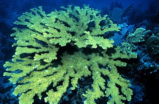
Elkhorn coral is an important reef-building coral in the Caribbean. The species has a complex structure with many branches which resemble that of elk antlers; hence, the common name. The branching structure creates habitat and shelter for many other reef species. Elkhorn coral is known to grow quickly with an average growth rate of 5 to 10 cm per year. They can reproduce both sexually and asexually, though asexual reproduction is much more common and occurs through a process called fragmentation.

<span class="mw-page-title-main">Index of the Bahamas–related articles</span>

The following is an alphabetical list of topics related to the Commonwealth of The Bahamas.

<span class="mw-page-title-main">Long Island, Bahamas</span> Island and district in The Bahamas

Long Island is an island in The Bahamas that is split by the Tropic of Cancer. It is one of the Districts of the Bahamas and is known as the most scenic island in the Bahamas. Its capital is Clarence Town. The population of Long Island is 3,094 inhabitants.

<span class="mw-page-title-main">1856 Atlantic hurricane season</span> Hurricane season in the Atlantic Ocean

The 1856 Atlantic hurricane season featured six tropical cyclones, five of which made landfall. The first system, Hurricane One, was first observed in the Gulf of Mexico on August 9. The final storm, Hurricane Six, was last observed on September 22. These dates fall within the period with the most tropical cyclone activity in the Atlantic. Only two tropical cyclones during the season existed simultaneously. One of the cyclones has only a single known point in its track due to a sparsity of data. Operationally, another tropical cyclone was believed to have existed in the Wilmington, North Carolina area in September, but HURDAT – the official Atlantic hurricane database – excludes this system. Another tropical cyclone that existed over the Northeastern United States in mid-August was later added to HURDAT.

<span class="mw-page-title-main">Bahamas–Spain relations</span> Bilateral relations

Bilateral and diplomatic relations exist between The Bahamas and Spain. The Spanish embassy in Kingston, Jamaica, is accredited for Bahamas.

References

Citations

  1. "Census Population and Housing" (PDF). Bahamas Government. Retrieved 17 April 2023.
  2. Stark (1891), p.  151.
  3. 1 2 3 Major (1870) , p.  2.
  4. Ahrens (2015), p. 101.
  5. 1 2 Littler, M.M.; Littler, D.S.; Blair, S.M.; Norris, J.N. (1986). "Deep-water plant communities from an uncharted seamount off San Salvador Island, Bahamas: distribution, abundance, and primary productivity". Deep Sea Research. 33 (7): 881–892. doi:10.1016/0198-0149(86)90003-8.
  6. 1 2 Peckol, P.M.; Curran, A.; Greenstein, B.J.; Blair, S.M.; Norris, J.N. (2003). "Assessment of coral reefs off San Salvador Island, Bahamas(stony corals, algae and fish populations)". Atoll Research Bulletin. 496: 124–145. doi:10.5479/si.00775630.496-7.124.
  7. 1 2 3 4 5 6 Gerace, D.T.; Ostrander, G.K.; Smith, G.W. (1998). "San Salvador, Bahamas". Caribbean Coastal Marine Productivity: 229–245.
  8. "Tide Predictions - San Salvador TEC4631 Tidal Data Daily View - NOAA Tides & Currents". tidesandcurrents.noaa.gov. Retrieved 2017-04-20.
  9. Talley, L.D. (2011). Descriptive physical oceanography: an introduction. Academic press.
  10. "Jacksonville Marine Lab/ Bolles School/ Robin Paris drifters deployed in 2016". nefsc.noaa.gov. Retrieved 2017-04-20.
  11. "Debris piece in Bahamas matches El Faro's cargo log". USA TODAY. Retrieved 2017-04-20.
  12. Nash (2015), p. 18.
  13. Phillips (2012).
  14. Brown (1970), p. 2.
  15. Major (1870), p.  5.
  16. 1 2 Major (1870) , p.  6.
  17. Major (1870), p.  15.
  18. Major (1870), p.  8.
  19. Adiele (2017), pp. 309–316.
  20. 1 2 Major (1870) , p.  9.
  21. 1 2 Major (1870) , p.  8.
  22. Major (1870), p.  7.
  23. 1 2 Act 27 of the Year 1926: Cat Island and San Salvador or Watlings Island Names Act. Government of the Bahamas.
  24. Muñoz (1793), p.  85–86.
  25. Becher (1856).
  26. Murdock (1884).
  27. Major (1871), pp.  171–72.
  28. Herbermann, Charles, ed. (1913). "San Salvador (1)"  . Catholic Encyclopedia . New York: Robert Appleton Company.
  29. Pickering, Keith (1997), "Watlings Island Landfall", The Columbus Landfall Homepage: Just Where Did Columbus First See the New World? .
  30. Phillips & al. (1992), pp. 155.
  31. MCB 7 Cruise Book 1957–59 (PDF), Port Hueneme: Seabee Museum.
  32. Official site, Gerace Research Center.
  33. Garver, John (January 3, 2003). "Some effects of Hurricane Lili (Oct 1996)". Union College . Retrieved October 10, 2010.
  34. 1 2 Curran, H. A., Delano, P., White, B., and Barrett, M., 2001, "Coastal Effects of Hurricane Floyd on San Salvador Island, Bahamas," In Proceedings of the 10th Symposium on the Geology of The Bahamas, 2001. Greenstein, B. J., and Carney, C. K.(eds.)
  35. "Hurricane Joaquin Exits Bahamas; Several Islands "Completely Obliterated"". The Weather Channel. 3 October 2015. Retrieved 4 October 2015.
  36. Curran, HA and B White. Field Guide to the Cockburn Town Fossil Coral Reef, San Salvador, Bahamas. p. 71-96., In Proceedings of the 2nd Symposium on the Geology of The Bahamas, 1984. JW Teeter (ed.).
  37. www.thebahamasguide.com/islands/sansalvador/default.htm "San Salvador" Archived 2012-09-12 at archive.today , The Bahamas Guide, Retrieved 6 March 2001
  38. http://www.bahamas.com/islands/san-salvador "San Salvador", The Official site of the Bahamas, Retrieved 21 September 2013
  39. http://www.bahamas.com/islands/san-salvador "San Salvador", The Bahamas, Retrieved 21 September 2013
  40. San Salvador Population by Settlement and Total Number of Occupied Dwellings (PDF), Bahamas Department of Statistics, 2010.

Bibliography