Sand Mountain (Alabama)

Last updated

Sand Mountain (Alabama)
Sandmtn.png
Sand Mountain in Alabama
Geography
Location Alabama, United States
Parent range Appalachian Mountains
Geology
Type of rock Sandstone

Sand Mountain is a sandstone plateau in northeastern Alabama and (to a far lesser extent) northwestern Georgia and southeastern Tennessee where the plateau is known as Raccoon Mountain and Elder Mountain. It is part of the southern tip of the Appalachian mountain chain and it is the largest plateau in the chain. Geologically a continuation of Walden Ridge, Sand Mountain is part of the Cumberland Plateau, separated from the main portion of the plateau by the Tennessee River and Sequatchie Valley. The average elevation on Sand Mountain is around 1,500 feet (460 m) above sea level, compared to about 650 feet (200 m) in the surrounding area. [1] This elevation leads to its having the coolest climate in the state of Alabama. [2] The largest city on Sand Mountain is Albertville, in Marshall County. As of the 2020 census, the population of the city was 22,386. [3]

Contents

History

Prehistory through the Colonial Period

The Sand Mountain area has been inhabited for at least 9,000 years, as evidenced by archaeological finds at nearby Russell Cave National Monument, near Bridgeport, Alabama. [4] In historical times, Cherokee and Creek villages were located in the Tennessee Valley to the west of Sand Mountain, and in Wills Valley to the east. Sequoyah, creator of the Cherokee syllabary, lived in the Cherokee village of Wills Town, near present-day Fort Payne in Wills Valley. [5]

The first Europeans to see it were probably Spanish explorer Hernando de Soto and his men, who are believed to have crossed Sand Mountain during their journey through southeastern North America between 1539 and 1543. One of the likely routes for the expedition traces their path across Sand Mountain on the way south from the Tennessee Valley to the Coosa Valley. [6]

Civil War

Union troops under Major General George H. Thomas crossed Sand Mountain in September 1863 in an attempt to cut off the Confederate troops in Chattanooga. They were unsuccessful, and the opposing armies met at the Battle of Chickamauga on September 19–20, 1863, resulting in a major Confederate victory. [7]

Jackson and DeKalb counties, along with the other counties of north Alabama, had voted against immediate secession in December 1860, and pro-Union sentiment remained strong on Sand Mountain. In early 1861, citizens in several northeastern counties proposed breaking away from Alabama and joining with neighboring counties of East Tennessee to create a new Union state of Nickajack. [8] Industries such as mining, milling, and working for the railroad were acceptable as exemptions to military service for Southern unionists, and some on Sand Mountain who did not wish to serve in the army worked at Sauta Cave in the Tennessee Valley, mining potassium nitrate to make gunpowder at Selma. [9]

In September 1861, the "Paint Rock Rifles" were raised on Sand Mountain by Confederate Colonel Lemuel Green Mead of Jackson County. They became Company C of the 26th Alabama Infantry Regiment, and served with distinction at the Battle of Shiloh in April 1862. Mead resigned his infantry commission in July 1862, after Union troops had invaded north Alabama, and organized an independent company of partisan rangers who carried out guerrilla raids against occupying Union forces. The company was the core of what eventually became Mead's Alabama and Tennessee Cavalry Battalion. [10]

In the summer of 1862, "Gunter's 1st Partisan Ranger Battalion" was formed on Sand Mountain in Jackson County by Major William T. Gunter. The battalion consisted of five mounted companies and served under Lieutenant General Nathan Bedford Forrest in skirmishes along the Tennessee River. In November 1862, the battalion was merged with the 33rd Alabama Infantry Regiment. [11]

A Union regiment, the 1st Tennessee and Alabama Vidette Cavalry, was formed at Union-occupied Stevenson, Alabama, in 1863, drawing men primarily from Sand Mountain, many of them Confederate deserters. However, the regiment was never all together and the companies were scattered around the area on guard duty. It was eventually disbanded before the end of the war. [12]

20th century

Sand Mountain was home, from 1903 to 1905, to a short-lived commune of forty Russian Jewish families attempting to form a collective farm and manufacturing concern. Due to the isolation of the area from other Jewish communities, the limestone soil of the area, and disharmony within the group, the project was abandoned and the inhabitants relocated after two years. [13]

Geography

Sand Mountain viewed from Trenton, Georgia Sand Mountain, viewed from Trenton, Georgia.jpg
Sand Mountain viewed from Trenton, Georgia

Sand Mountain runs in a diagonal northeast-southwest direction from the northeastern corner of Alabama, and includes parts of Jackson, DeKalb, Marshall, Etowah and Blount counties in Alabama, as well as part of Dade County, Georgia. [14]

Sand Mountain, especially the northern end, i.e. eastern Jackson County and northern DeKalb County, is mostly a rural, [15] agricultural area, with a mix of chicken, cow, and potato farms, as well as other assorted farms, [16] and large expanses of both rolling pastures and forests. [1] It contains many small towns (less than 1,000 people) and unincorporated communities.

Current issues and social characteristics

Politically and religiously, Sand Mountain is a fairly conservative place, consistently voting for conservative candidates in elections, [17] and with Baptists claiming the largest number of congregants of any church denomination. [18] Much of Sand Mountain is dry, with the sale of alcoholic beverages being forbidden. [19]

Sand Mountain is one of the last places in the country with churches which still use Sacred Harp singing in their Sunday morning church services, and is home to many of the largest and oldest continuous Sacred Harp singings in the country, as well as many important singers (i.e. editors of the Sacred Harp tunebook). [20] [21]

Snake handling by some churches on Sand Mountain was the subject of Salvation on Sand Mountain , a 1996 book by Dennis Covington. [22] Those who live on Sand Mountain state that the book mostly took place in Scottsboro, in the Tennessee River valley to the west of Sand Mountain.

Climate

Sand Mountain, being located in the mid-South, has long hot humid summers, and winters which are short and mild by comparison to much of the rest of the country, with snow being a real rarity. Its elevation, however, leads to it being cooler than the rest of the state of Alabama. [23] [24] [25] [26] [27] On Sand Mountain, between 60 and 90 days per year are over 86 °F (30 °C), according to the Heat Zone Map published by the American Horticultural Society. [28] By comparison, the great majority of the upper Midwest and Northeast has less than 30 such days per year. [28] These hot days, combined with the South's high humidity, make it sweltering in the summer. The average daytime temperature is in the high 70s or above for at least five months out of the year (May through September). [23] [24] [25] [26] [27] Sand Mountain has higher rainfall than almost anywhere else in the South, including anywhere else in Alabama, with the exception of the Gulf Coast area. [29] Some areas of Sand Mountain get more than 66 inches (1,700 mm) of rainfall per year (though others get as little as 54 inches (1,400 mm)). [30]

The following is a general idea of Sand Mountain's climate, taken from Ider, Alabama:

Climate data for Sand Mountain, Alabama (spec. Ider, Ala.)
MonthJanFebMarAprMayJunJulAugSepOctNovDecYear
Average high °F (°C)48
(9)
53
(12)
61
(16)
70
(21)
77
(25)
84
(29)
88
(31)
87
(31)
82
(28)
72
(22)
61
(16)
51
(11)
70
(21)
Average low °F (°C)26
(−3)
28
(−2)
35
(2)
42
(6)
52
(11)
60
(16)
65
(18)
64
(18)
57
(14)
44
(7)
36
(2)
29
(−2)
45
(7)
Average precipitation inches (mm)6.06
(154)
5.62
(143)
6.57
(167)
4.73
(120)
4.70
(119)
4.33
(110)
5.18
(132)
3.49
(89)
4.27
(108)
3.29
(84)
5.00
(127)
5.12
(130)
58.36
(1,482)
Source: Weather.com [31]

Soil

Sand Mountain has, on average, a 2-to-4-foot (0.6 to 1.2 m) depth of soil - after which is solid sandstone bedrock. The soil is generally loam-based, and is a mixture of sandy loam and silty loam, drawing from such series as Apison, Atkins, Cotaco-Barbourville, Crossville, Hartsells, Lickdale, and Muskingum. It is extremely acidic, growing more so the deeper you go from the top. It is classified as "well-drained".

Settlements located on Sand Mountain

Jackson County

DeKalb County

Marshall County

Etowah County

Blount County

See also

Related Research Articles

<span class="mw-page-title-main">Geography of Alabama</span> Geographical features of Alabama

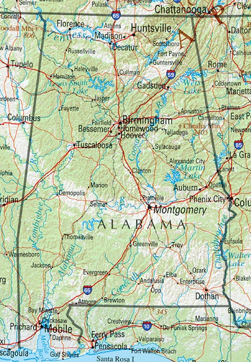
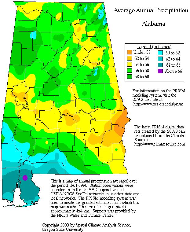
The geography of Alabama describes a state in the Southeastern United States in North America. It extends from high mountains to low valleys and sandy beaches. Alabama is 30th in size and borders four U.S. states: Mississippi, Tennessee, Georgia, and Florida. It also borders the Gulf of Mexico.

<span class="mw-page-title-main">Tennessee</span> U.S. state

Tennessee, officially the State of Tennessee, is a landlocked state in the Southeastern region of the United States. Tennessee is the 36th-largest by area and the 15th-most populous of the 50 states. It is bordered by Kentucky to the north, Virginia to the northeast, North Carolina to the east, Georgia, Alabama, and Mississippi to the south, Arkansas to the southwest, and Missouri to the northwest. Tennessee is geographically, culturally, and legally divided into three Grand Divisions of East, Middle, and West Tennessee. Nashville is the state's capital and largest city, and anchors its largest metropolitan area. Other major cities include Memphis, Knoxville, Chattanooga, and Clarksville. Tennessee's population as of the 2020 United States census is approximately 6.9 million.

<span class="mw-page-title-main">DeKalb County, Alabama</span> County in Alabama, United States

DeKalb County is a county located in the northeastern part of the U.S. state of Alabama. As of the 2020 census, the population was 71,608. Its county seat is Fort Payne, and it is named after Major General Baron Johan DeKalb. DeKalb County is part of the Huntsville-Decatur-Albertville, AL Combined Statistical Area.

<span class="mw-page-title-main">Marion County, Tennessee</span> County in Tennessee, United States

<span class="mw-page-title-main">Bradley County, Tennessee</span> County in Tennessee, United States

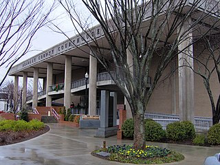
Bradley County is a county located in the southeastern portion of the U.S. state of Tennessee. As of the 2020 census, the population was 108,620, making it the thirteenth most populous county in Tennessee. Its county seat is Cleveland. It is named for Colonel Edward Bradley of Shelby County, Tennessee, who was colonel of Hale's Regiment in the American Revolution and the 15th Regiment of the Tennessee Volunteers in the War of 1812. Bradley County is included in the Cleveland, Tennessee Metropolitan Statistical Area, which is also included in the Chattanooga-Cleveland-Dalton, TN-GA-AL Combined Statistical Area.

<span class="mw-page-title-main">Crossville, Alabama</span> Town in Alabama, United States

Crossville is a town in DeKalb County, Alabama, United States. At the 2010 census the population was 1,862, up from 1,431 in 2000. Crossville is located atop Sand Mountain, a southern extension of the Cumberland Plateau.

<span class="mw-page-title-main">Ider, Alabama</span> Town in Alabama, United States

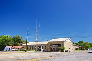
Ider is a town in DeKalb County, Alabama, United States. At the 2020 census, the population was 735. It incorporated in October 1973.

<span class="mw-page-title-main">Albertville, Alabama</span> City in Alabama, United States

Albertville is a city in Marshall County, Alabama, United States, and is included in the Huntsville-Decatur Combined Statistical Area. As of the 2020 census, the population of the city was 22,386. It is the largest city in Marshall County.

<span class="mw-page-title-main">Tennessee River</span> River in the southeastern United States

The Tennessee River is the largest tributary of the Ohio River. It is approximately 652 miles (1,049 km) long and is located in the southeastern United States in the Tennessee Valley. The river was once popularly known as the Cherokee River, among other names, as the Cherokee people had their homelands along its banks, especially in what are now East Tennessee and northern Alabama. Additionally, its tributary, the Little Tennessee River, flows into it from Western North Carolina and northeastern Georgia, where the river also was bordered by numerous Cherokee towns. Its current name is derived from the Cherokee town, Tanasi, which was located on the Tennessee side of the Appalachian Mountains.

<span class="mw-page-title-main">Cumberland Plateau</span> Plateau in the United States

The Cumberland Plateau is the southern part of the Appalachian Plateau in the Appalachian Mountains of the United States. It includes much of eastern Kentucky and Tennessee, and portions of northern Alabama and northwest Georgia. The terms "Allegheny Plateau" and the "Cumberland Plateau" both refer to the dissected plateau lands lying west of the main Appalachian Mountains. The terms stem from historical usage rather than geological difference, so there is no strict dividing line between the two. Two major rivers share the names of the plateaus, with the Allegheny River rising in the Allegheny Plateau and the Cumberland River rising in the Cumberland Plateau in Harlan County, Kentucky.

<span class="mw-page-title-main">East Tennessee</span> Geographic and cultural region of Tennessee, United States

East Tennessee is one of the three Grand Divisions of Tennessee defined in state law. Geographically and socioculturally distinct, it comprises approximately the eastern third of the U.S. state of Tennessee. East Tennessee consists of 33 counties, 30 located within the Eastern Time Zone and three counties in the Central Time Zone, namely Bledsoe, Cumberland, and Marion. East Tennessee is entirely located within the Appalachian Mountains, although the landforms range from densely forested 6,000-foot (1,800 m) mountains to broad river valleys. The region contains the major cities of Knoxville and Chattanooga, Tennessee's third and fourth largest cities, respectively, and the Tri-Cities, the state's sixth largest population center.

<span class="mw-page-title-main">Lookout Mountain</span> Mountain in northwestern Georgia, United States

Lookout Mountain is a mountain ridge located at the northwest corner of the U.S. state of Georgia, the northeast corner of Alabama, and along the southeastern Tennessee state line in Chattanooga. Lookout Mountain was the scene of the 18th-century "Last Battle of the Cherokees" in this area during the Nickajack Expedition. On November 24, 1863, during the American Civil War, the Battle of Lookout Mountain took place here.

<span class="mw-page-title-main">North Alabama</span> Region in Alabama

<span class="mw-page-title-main">Streight's Raid</span> Raid during the American Civil War

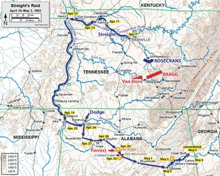
Streight's Raid took place in northern Alabama during the American Civil War. It was led by Union Army Col. Abel Streight and opposed by Confederate Brig. Gen. Nathan Bedford Forrest. Streight's goal was to destroy parts of the Western and Atlantic Railroad, which was supplying the Confederate Army of Tennessee. The raid was poorly supplied and planned, and ended with the defeat of Streight and his 1,700 men at Cedar Bluff, Alabama, by Forrest who bluffed his opponent into surrendering to his 500 men. Streight was additionally hindered by locals throughout his march, while pursued by Forrest, who had the advantage of home territory and the sympathy and aid of the local populace, most famously Emma Sansom.

This is a list of Confederate government Civil War military units, not raised by any state.

<span class="mw-page-title-main">Cherokee in the American Civil War</span>

The Cherokee in the American Civil War were active in the Trans-Mississippi and Western Theaters. In the east, Confederate Cherokees led by William Holland Thomas hindered Union forces trying to use the Appalachian mountain passes of western North Carolina and eastern Tennessee. Out west, Confederate Cherokee Stand Watie led primarily Native Confederate forces in the Indian Territory, in what is now the state of Oklahoma. The Cherokee partnered with the Confederacy in order to get funds, as well as ultimately full recognition as a sovereign, independent state.

Barton, also known as Barton Station, Barton Depot, or Barton's, is an unincorporated community located in western Colbert County, Alabama, United States. It is about ten miles west of the county seat of Tuscumbia, and just south of Tennessee River. The community is about four miles southeast of Cherokee on US Route 72.

The 72nd Indiana Infantry Regiment, also known as 72nd Indiana Mounted Infantry Regiment, was an infantry and mounted infantry regiment that served in the Union Army during the American Civil War. The regiment served as mounted infantry from March 17, 1863, to November 1, 1864, notably as part of the Lightning Brigade during the Tullahoma and Chickamauga Campaigns.

<span class="mw-page-title-main">15th Alabama Infantry Regiment</span> Military unit

The 15th Alabama Infantry Regiment was a Confederate volunteer infantry unit from the state of Alabama during the American Civil War. Recruited from six counties in the southeastern part of the state, it fought mostly with Robert E. Lee's Army of Northern Virginia, though it also saw brief service with Braxton Bragg and the Army of Tennessee in late 1863 before returning to Virginia in early 1864 for the duration of the war. Out of 1,958 men listed on the regimental rolls throughout the conflict, 261 are known to have fallen in battle, with sources listing an additional 416 deaths due to disease. 218 were captured, 66 deserted and 61 were transferred or discharged. By the end of the war, only 170 men remained to be paroled.

<span class="mw-page-title-main">Taylor Ridge (Georgia)</span>

Taylor Ridge is the most northwestern ridge in the state of Georgia within the Ridge and Valley physiographic region and is approximately 40 miles (64 km) in length. To the west the ridge is bordered by the Cumberland Plateau region and to the north Taylor Ridge becomes White Oak Mountain at Ringgold Gap although technically part of the same ridge. The western foothills of Taylor Ridge are also the western border of the Chattahoochee National Forest. Taylor Ridge is part of the Armuchee Ridges which also consist of Little Sand Mountain, Dicks Ridge, Johns Ridge, Horn Mountain and Rocky Face. Taylor Ridge runs south to north through Chattooga, Walker, Whitfield, and Catoosa counties along the towns of Summerville, Trion, Lafayette and Ringgold. The highpoint of the ridge is 1,665 feet (507 m) where the ridge buckles with Dicks Ridge. An area labeled high point is 1,432 feet (436 m) at the ridges southern terminus along GA highway 100.

References

  1. 1 2 Google Earth
  2. "Archived copy". Archived from the original on July 30, 2010. Retrieved May 26, 2009.{{cite web}}: CS1 maint: archived copy as title (link)
  3. "Sand Mountain, Alabama: Information, History & Outdoor Activities". Sand-boarding.com. Retrieved June 18, 2023.
  4. David Hurst Thomas, Exploring Ancient Native America, Routledge, 1999, pg 77.
  5. Thomas E. Mails, The Cherokee People, Council Oak Books, 1992, pg 343.
  6. Charles Hudson, Knights of Spain, Warriors of the Sun: Hernando de Soto and the South's Ancient Chiefdoms, University of Georgia Press, 1998, pg 460.
  7. Victor Hicken, Illinois in the Civil War, University of Illinois Press; 1991, p. 194
  8. Fleming, Walter L., Civil War and Reconstruction in Alabama. New York: Columbia University Press, 1905, pp 109-111.
  9. Storey, Margaret M., Loyalty and Loss, Alabama's Unionists in the Civil War and Reconstruction, Louisiana State University Press, 2004.
  10. "Lemuel Green Mead (1830-1878)". History-sites.com. Archived from the original on July 11, 2011. Retrieved December 14, 2010.
  11. "Alabama Infantry Regiments, Histories of". History-sites.com. Archived from the original on February 12, 2011. Retrieved December 14, 2010.
  12. Potter, Johnny, First Tennessee & Alabama Independent Vidette Cavalry Roster, 1863-1864, Mountain Press, 1995.
  13. "Sand Mountain, Alabama". Institute of Southern Jewish Life. Retrieved November 28, 2017.
  14. "Archived copy". Archived from the original on March 21, 2016. Retrieved May 26, 2009.{{cite web}}: CS1 maint: archived copy as title (link)
  15. "Archived copy". Archived from the original on December 26, 2013. Retrieved May 26, 2009.{{cite web}}: CS1 maint: archived copy as title (link)
  16. "Archived copy". Archived from the original on March 3, 2016. Retrieved May 26, 2009.{{cite web}}: CS1 maint: archived copy as title (link)
  17. "President Map - Election Results 2008 - the New York Times". The New York Times.
  18. "American FactFinder". Factfinder.census.gov. Retrieved December 14, 2010.[ permanent dead link ]
  19. "Archived copy". Archived from the original on March 3, 2016. Retrieved May 26, 2009.{{cite web}}: CS1 maint: archived copy as title (link)
  20. "Archived copy". Archived from the original on March 3, 2016. Retrieved May 26, 2009.{{cite web}}: CS1 maint: archived copy as title (link)
  21. The Sacred Harp, 1991 edition.
  22. Dennis Covington, Salvation on Sand Mountain: Snake-Handling and Redemption in Southern Appalachia, Penguin (Non-Classics):March 1, 1996
  23. 1 2 "PRISM Products". Prism.oregonstate.edu. Archived from the original on July 20, 2010. Retrieved December 14, 2010.
  24. 1 2 "PRISM Products". Prism.oregonstate.edu. Archived from the original on July 20, 2010. Retrieved December 14, 2010.
  25. 1 2 "PRISM Products". Prism.oregonstate.edu. Archived from the original on July 20, 2010. Retrieved December 14, 2010.
  26. 1 2 "PRISM Products". Prism.oregonstate.edu. Archived from the original on July 20, 2010. Retrieved December 14, 2010.
  27. 1 2 "PRISM Products". Prism.oregonstate.edu. Archived from the original on July 20, 2010. Retrieved December 14, 2010.
  28. 1 2 "AdventHealth | A Leader in Whole-Person Health Care" (PDF). Archived (PDF) from the original on August 12, 2012. Retrieved September 15, 2009.
  29. [ dead link ]
  30. "Archived copy". Archived from the original on February 21, 2012. Retrieved May 24, 2009.{{cite web}}: CS1 maint: archived copy as title (link)
  31. "Average Weather for Ider, AL". The Weather Channel. 2009. Retrieved May 24, 2009.

34°27′N86°00′W / 34.450°N 86.000°W / 34.450; -86.000