Orma is an unincorporated community in Calhoun County, West Virginia, United States. It lies along West Virginia Route 16 and the West Fork Little Kanawha River, to the south of the town of Grantsville, the county seat of Calhoun County. Its elevation is 738 feet. It has a post office with the ZIP code 25268.
Chloe is an unincorporated community in Calhoun County, West Virginia, United States. It lies along West Virginia Route 16 and the West Fork Little Kanawha River, to the south of the towns of Grantsville and Arnoldsburg. Its elevation is 794 feet (242 m). It has a post office with the ZIP code 25235.
Arnoldsburg is an unincorporated community in Calhoun County, West Virginia, United States. It lies along U.S. Route 33 at the point where West Virginia Route 16 heads southward; it is several miles south of the county seat of Grantsville. Its elevation is 738 feet. The West Fork Little Kanawha River flows through the community. It has a post office with the ZIP code 25234.
Big Bend is an unincorporated community in Calhoun County, West Virginia, United States. It lies along West Virginia Route 5 northwest of the town of Grantsville, the county seat of Calhoun County, along the Little Kanawha River. Its elevation is 682 feet. It has a post office with the ZIP code 26136.

Brooks is an unincorporated community in Summers County, West Virginia, United States. It lies along the New River to the north of the city of Hinton, the county seat of Summers County. Its elevation is 1,657 feet.
Forest Hill is an unincorporated community in Summers County, West Virginia, United States. It lies along West Virginia Route 12 to the southeast of the city of Hinton, the county seat of Summers County. Its elevation is 1,926 feet. It has a post office with the ZIP code 24935.
Green Sulphur Springs is an unincorporated community in Summers County, West Virginia, United States. It lies near Interstate 64 to the northeast of the city of Hinton, the county seat of Summers County. Its elevation is 1,552 feet. Green Sulphur Springs had a post office, with the ZIP code of 25966, until it closed on February 29, 1992.
Nimitz is an unincorporated community in Summers County, West Virginia, United States. It lies along West Virginia Route 3 to the west of the city of Hinton, the county seat of Summers County. Its elevation is 2,523 feet. It has a post office with the ZIP code 25978.
Pipestem is an unincorporated community in Summers County, West Virginia, United States. It lies along West Virginia Route 20 to the south-southwest of the city of Hinton, the county seat of Summers County. Its elevation is 2,382 feet. It has a post office with the ZIP code 25979. It has a population of 764 people.

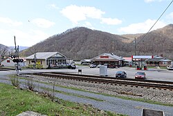
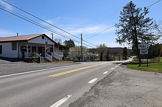
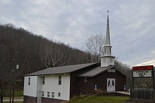
Talcott is an unincorporated community in Summers County, West Virginia, United States.
New Milton is an unincorporated community in central Doddridge County, West Virginia, United States. The community is located along Meathouse Fork, southeast of the town of West Union, the county seat of Doddridge County. Its elevation is 833 feet (254 m). It had a post office with the ZIP code 26411, but was closed several years ago
Griffithsville is an unincorporated community in eastern Lincoln County, West Virginia, United States. It lies along West Virginia Route 3 southeast of the town of Hamlin, the county seat of Lincoln County. Its elevation is 659 feet (201 m). It has a post office with the ZIP code 25521.
Ranger is an unincorporated community in western Lincoln County, West Virginia, United States. It lies along West Virginia Route 10 southwest of the town of Hamlin, the county seat of Lincoln County. Its elevation is 614 feet (187 m). It has a post office with the ZIP code 25557. Ranger is served by the Guyan River VFD.
Wana — formerly Wise — is an unincorporated community in northwestern Monongalia County, West Virginia, United States. It lies along West Virginia Route 7 northwest of the city of Morgantown, the county seat of Monongalia County. Its elevation is 1,030 feet (314 m). It has a post office with the ZIP code 26590.
Berea is an unincorporated community in southeastern Ritchie County, West Virginia, United States. It lies along West Virginia Route 74 southeast of the town of Harrisville, the county seat of Ritchie County. Its elevation is 751 feet (229 m). Although it is unincorporated nor has a post office, the ZIP code is 26327. Postal customers are serviced by the Harrisville and Auburn post offices.

Smithville is an unincorporated community in southern Ritchie County, West Virginia, United States. It lies along West Virginia Route 47 south of the town of Harrisville, the county seat of Ritchie County. Its elevation is 686 feet (209 m). It has a post office with the ZIP code 26178.
Creston is an unincorporated community in southeastern Wirt County, West Virginia, United States. It lies at the confluence of the Little Kanawha River and the West Fork Little Kanawha River on West Virginia Route 5, southeast of the town of Elizabeth, the county seat of Wirt County. Its elevation is 653 feet (199 m). Creston had a post office, which closed on June 25, 2011. The community was named for a drainage divide near the town site.
Dallas is an unincorporated community in northeastern Marshall County, West Virginia, United States. It lies along local roads northeast of the city of Moundsville, the county seat of Marshall County, and almost in Pennsylvania. Its elevation is 1,388 feet (423 m). It has a post office with the ZIP code 26036.
Glen Easton is an unincorporated community in southern Marshall County, West Virginia, United States. It lies along local roads southeast of the city of Moundsville, the county seat of Marshall County. Its elevation is 945 feet (288 m). It has a post office with the ZIP code 26039.
Proctor is an unincorporated community in northwestern Wetzel County, West Virginia, United States. It lies on West Virginia Route 2 along the Ohio River, north of the city of New Martinsville, the county seat of Wetzel County. Its elevation is 630 feet (192 m). Because the community has borne multiple names, the Board on Geographic Names officially designated it "Proctor" in 1980. It has a post office with the ZIP code 26055.