
South Kivu is one of 26 provinces of the Democratic Republic of the Congo (DRC). Its capital is Bukavu.
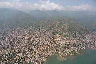
Uvira is the capital city of the Uvira Territory in the South Kivu Province of the Democratic Republic of the Congo (DRC). It is situated between Lake Tanganyika and the Mitumba Mountains and covers an area of approximately 16km.
Minembwe is a cluster of several villages located in the highlands of the Lulenge, within the Fizi Territory of South Kivu Province in the Democratic Republic of the Congo (DRC). It is situated at an altitude of about 2,500 meters above sea level, in a hilly and mountainous region covered with forests, which provides fertile land for agriculture. It is approximately 150 kilometers south of Bukavu, the capital city of South Kivu. The region is also home to various streams and rivers that flow into Lake Tanganyika, the second-deepest lake in the world.
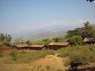
Mulenge is a village encircled by hills in the Bafuliiru Chiefdom, located in the Uvira Territory of South Kivu Province, Democratic Republic of the Congo (DRC). It is situated on the high plateaus of the Itombwe massif, overlooking the locality of Uvira. The area has conventionally been inhabited by various ethnic groups, including the remnants of the autochthonous population of African Pygmies, as well as Bantu ethnic groups such as the Mbuti, Fuliiru, and Nyindu. The region boasts high agricultural productivity, with two harvests typically achievable each year.

Runingo, commonly known as Runingu, is one of the groupements (groupings) that constitutes the Bafuliiru Chiefdom in the Uvira Territory of the South Kivu Province in the eastern part of the Democratic Republic of the Congo (DRC). It is situated near the border with Burundi, along National Highway 5, to the north of Butaho.

The Fuliiru people are a Bantu ethnic group predominantly inhabiting the east-central highlands of the Democratic Republic of the Congo (DRC). They reside in the South Kivu Province, situated south of Lake Kivu and to the north and northwest of Uvira Territory, along the Ruzizi Plain near the border with Rwanda and Burundi, where a contingent of Fuliiru also resides. According to the 2009 census, their population estimate exceeded 250,000, while a 1999 estimate of Kifuliiru-language speakers placed the number at 300,000. The Fuliiru are renowned for their skilled craftsmanship, particularly in the production of pottery and basketry. Their handcrafted baskets are highly coveted for their intricate designs and exceptional quality, and are frequently employed for storage, decoration, and even as musical instruments.

Uvira Territory is a territory in South Kivu, Democratic Republic of the Congo. It is bordered by Walungu Territory to the north, Mwenga Territory to the west, Fizi Territory to the south, and Burundi and Lake Tanganyika to the east. Its capital is Uvira.

Luvungi, also known as Itara-Luvungi, is one of the groupements (groupings) within the Bafuliiru Chiefdom in the Uvira Territory of the South Kivu Province in the eastern Democratic Republic of the Congo (DRC). Situated on the Ruzizi Plain, it lies at the borders of Uvira Territory and Walungu Territory, in close proximity to the frontiers of Rwanda and Burundi. Luvungi is home to a population of approximately 85,000 individuals, predominantly consisting of Fuliru agriculturalists who play a vital role in the local community. There's also has a small population of Vira, Bembe, Lega, Shi, Burundians and Banyamulenge. Its economy is founded mainly on subsistence agriculture and the artisanal mining of cassiterite, an ore of tin.
Lemera is one of the groupements (groupings) within the Bafuliiru Chiefdom, located in the Uvira Territory of the South Kivu Province in the eastern part of the Democratic Republic of the Congo (DRC). It is situated in the northwestern part of the Uvira Territory, approximately 60 kilometers north of Bukavu and 90 kilometers southwest of the border with Rwanda and Burundi. Lemera is in close proximity to several villages, including Kasheke, Nyambasha, Luzira, Lukayo, Kajuju, Lushasha, and Ihusi.

Katogota is a village located in the Itara-Luvungi grouping within the Bafuliiru Chiefdom in Uvira Territory of the South Kivu Province in the Democratic Republic of the Congo (DRC). Situated approximately 60 km south of Bukavu, Katogota is in close proximity to the Kamonyi and Rusagara villages, near the border regions of Rwanda and Burundi.

Kamanyola is one of the groupements (groupings) within the Ngweshe Chiefdom of the Walungu Territory. It is located in the Ruzizi Plain in the South Kivu Province of the Democratic Republic of the Congo (DRC), sharing a border with Rwanda and Burundi. Kamanyola stands at a height of 901 meters and is closely situated to the suburb of Mwaro and the village of Mubombo.
Bwegera is a village in the Bafuliiru Chiefdom in the Uvira Territory of South Kivu Province, Democratic Republic of the Congo. Bwegera has an elevation of 952 meters and is situated in the vicinity of the Kakamba and Nyaruhuhuma villages. The region It's crossed by Lake Tanganyika, providing a vital source of water and transportation for the local inhabitants. Bwegera is rich in building materials such as rubble, sand, and baked bricks, making it an ideal location for construction and development. The region also encompasses a vast rural area where agriculture, animal breeding, and fishing are the primary means of livelihood.
Lubarika is a village situated in the hills and high plateaus of Bafuliiru Chiefdom in Uvira Territory, located in the South Kivu Province in the eastern part of the Democratic Republic of Congo (DRC). It sits at an elevation of 969 meters above sea level and is near the villages of Murunga and Nyakagobe II. Lubarika is a predominantly agricultural region with large hectares used for subsistence agriculture. Agriculture is practiced by an extensive segment of the population. The products grown are mainly intended for domestic consumption and commercialization. Moreover, fishing is carried out artisanally in Lake Tanganyika by the local population.

Mutambala is a sector that constitutes one of the four sectors in the Fizi Territory of the South Kivu Province in the eastern part of the Democratic Republic of the Congo. Mutambala is situated near Lake Tanganyika, in the west by the Lulenge sector, in the north by the Tangani'a sector, and in the south by the Ngandja sector. It has a surface area of 777 km 2. The sector consists of five groupings (groupements), including the Basimukindja groupings, the Batombwe groupings, and the Babwari groupings.

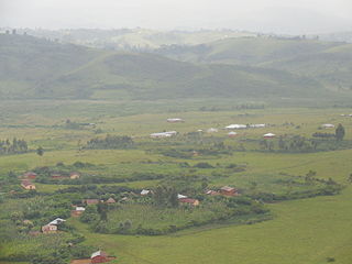
The Ruzizi Plain is a valley situated between the Mitumba mountain chain and the Ruzizi River. It serves as a natural border, separating the Democratic Republic of the Congo (DRC) from Burundi and Rwanda on the other side. The Ruzizi Plain is an integral part of the larger Western Rift Valley, which stretches across several African countries. It is traversed by the Ruzizi River, which flows from Lake Kivu through the plain and into Lake Tanganyika. It covers an area of 175,000 hectares divided between Burundi, Rwanda and the DRC. In Burundi, the plain extends to the northern sector of Imbo. It is bounded by parallels 2°36′ and 3°26′ south latitude and by meridians 29°00′ and 29°26 east longitude—an area of 1025 km2. The Congolese side is bounded to the north by the plain of Bugarama (Rwanda), to the east by the plain of Imbo (Burundi), to the West by the chain of Mitumba and to the South by Lake Tanganyika. The region covers thus about 80,000 hectares with 80 kilometers in length.
Kidote, also known as Kidoti, is a small village situated in the middle plateaux of Lemera, within the Bafuliiru Chiefdom of the Uvira Territory in the South Kivu Province in the eastern region of the Democratic Republic of the Congo (DRC). It also serves as a camp for Congolese Internally Displaced People (IDPs) from various regions of Bwegera.
Kiringye is a village situated in the Lemera groupement within the Bafuliiru Chiefdom, which is part of Uvira Territory in the South Kivu Province in the eastern region of the Democratic Republic of the Congo (DRC). The village is located at an elevation of 928 meters and is in close proximity to the localities of Luburule and Karenzu.

The Hospital General of Reference D'uvira, also known as General Referral Hospital of Uvira or Uvira General Reference Hospital, is a healthcare facility located in Uvira, the capital of the Uvira Territory in the South Kivu Province of the eastern region of the Democratic Republic of the Congo (DRC). It serves as a general hospital, providing medical services to the local population. The hospital offers a wide range of medical specialties and advanced healthcare services, including primary, secondary, and some tertiary care, such as emergency care, surgical procedures, maternal and child health services, and treatment for various medical conditions.

The Sange River is a tributary of the Ruzizi River in the eastern part of the Democratic Republic of the Congo (DRC). It serves as a reliable source of water for domestic and commercial use, and families living along its banks rely on its pristine waters for drinking, cooking, andhousehold chores. Local businesses depend on the river's abundant supply to meet the needs of visitors and tourists. Moreover, the river's flow sustains an ecosystem of services.
The Bafuliiru Chiefdom, formerly known as Chefferie des Bafulero, is a chiefdom located in the Democratic Republic of the Congo (DRC). It is situated in the Uvira Territory, which is part of the South Kivu Province in eastern DRC.
