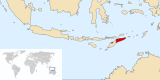
Flores is one of the Lesser Sunda Islands, a group of islands in the eastern half of Indonesia. Administratively, it forms the largest island in the East Nusa Tenggara Province. Including Komodo and Rinca islands off its west coast, the land area is 14,731.67 km2, and the population was 1,878,875 in the 2020 Census ; the official estimate as of mid-2023 was 1,962,405. The largest towns are Maumere and Ende. The name Flores is of Portuguese origin, meaning "Flowers".

East Kalimantan is a province of Indonesia. Its territory comprises the eastern portion of Borneo. It had a population of about 3.03 million at the 2010 census, 3.42 million at the 2015 census, and 3.766 million at the 2020 census; the official estimate as at mid 2023 was 4,030,488. Its capital is the city of Samarinda.

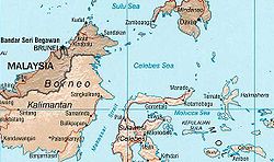
Makassar Strait is a strait between the islands of Borneo and Sulawesi in Indonesia. To the north it joins the Celebes Sea, while to the south it meets the Java Sea. To the northeast, it forms the Sangkulirang Bay south of the Mangkalihat Peninsula. The strait is an important regional shipping route in Southeast Asia.

UTC+08:00 is an identifier for a time offset from UTC of +08:00.

UTC+09:00 is an identifier for a time offset from UTC of +09:00.

UTC+07:00 is an identifier for a time offset from UTC of +07:00. In ISO 8601 the associated time would be written as 2024-06-02T15:04:47+07:00. It is 7 hours ahead of UTC, meaning that when the time in UTC areas is midnight (00:00), the time in UTC+07:00 areas would be 7:00 in the morning.

East Timor was a de facto province of Indonesia that existed between 1976 and 1999 during the Indonesian occupation of East Timor. Its territory corresponded to the previous Portuguese Timor and to the present-day independent country of Timor-Leste.

Mount Ilas Bungaan is a limestone hill near Berau, East Kalimantan, Borneo. It is also known as Flowering Rock, a literal translation of its Indonesian name. The hill is located "on a remote stretch of the Karangan River" and its base lies at an altitude of around 300 m.

Hose's langur is a species of primate in the family Cercopithecidae endemic to the island of Borneo, including Brunei, Kalimantan (Indonesia), and East Malaysia. Its natural habitat is subtropical or tropical dry forests. It is threatened by habitat loss. It was first identified in Kutai National Park and Sangkulirang Peninsula, East Kalimantan, Indonesia, in 1985.

The Manggarai language is the language of the Manggarai people from the western parts of the island of Flores, in East Nusa Tenggara Province, Indonesia.
Karangan or Karanagan or Kerengan may refer to:
The Sangkulirang-Mangkalihat Karst is a karstique area in Sub Kelay, Biatan, Talisayan, Batu Putih, and Biduk-biduk Berau districts of East Kalimantan province on the island of Borneo in Indonesia. It covers an area of 105,000 hectares, including the Mangkalihat Peninsula.
The Lebbo' people are part of the indigenous Dayak people of East Kalimantan and North Kalimantan, Indonesia.

Isran Noor is an Indonesian politician and academic who is the governor of East Kalimantan from 2018 to 2023.

Lubang Jeriji Saleh is a limestone cave complex in Indonesia in the Sangkulirang-Mangkalihat Karst, located in the remote jungle of Bengalon district in East Kutai, East Kalimantan province on Borneo island. In a 2018 publication, a team of researchers announced to have found the then-oldest known work of figurative art in the world among the cave paintings, at 40,000 years old. However, the same team has since found and dated an elaborate therianthrope rock art panel in the Leang Bulu' Sipong 4 cave in Sulawesi's Maros-Pangkep karst to around 44,000 years ago.
Cape Mangkalihat, also known as Cape Sangkulirang, is a cape in eastern Borneo. It is located in the Indonesian province of East Kalimantan, in the regencies of Berau and East Kutai.
The 2023–24 Liga 3 East Kalimantam is the sixth season of Liga 3 East Kalimantan organized by Asprov PSSI Kaltim.
Sangkulirang Football Club is an Indonesian football club based in Sangkulirang, East Kutai Regency, East Kalimantan. They currently compete in the Liga 3 East Kalimantan zone.
IP GP Caladium FC, commonly known as Caladium FC, is an Indonesian football club based in Balikpapan, East Kalimantan. They currently compete in the Liga 3 East Kalimantan zone.


