Sani Pass

Last updated

Sani Pass
Sani Pass heading into Lesotho.jpg
Elevation 2,876 m (9,436 ft) [1]
LocationBorder of KwaZulu Natal, South Africa and Mokhotlong, Lesotho
Range Drakensberg Mountains
Coordinates 29°35′17.3″S29°17′33.8″E / 29.588139°S 29.292722°E / -29.588139; 29.292722
South Africa KwaZulu-Natal relief location map.svg
Red pog.svg
Location in KwaZulu-Natal and Lesotho
Lesotho rel location map.svg
Red pog.svg
Sani Pass (Lesotho)

Sani Pass is a mountain pass located in the West of KwaZulu-Natal, South Africa on the road between Himeville, KwaZulu-Natal and Mokhotlong, Lesotho. The pass traverses the Great Escarpment of southern Africa in its highest region, the Drakensberg Mountains, which reach an elevation of over 3,000 meters.

Contents

Route

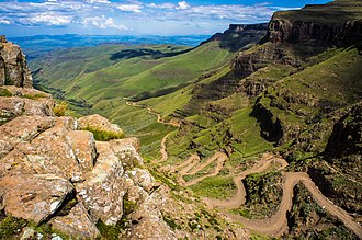
The route up Sani Pass starts at 1,544 metres (5,066 ft), and climbs 1,332 m (4,370 ft) to an altitude of 2,876 m (9,436 ft). The steep gravel road has gradients up to 1:3, which can be difficult to drive in bad weather and may be covered with snow and ice in winter. South Africa generally allows only 4x4 vehicles on the road. [1] The pass lies between the border controls of both countries and is approximately 9 km in length. [2] Caution must be exercised and motorists must be alert while navigating the pass as it has claimed many lives. [1] Occasionally the remains of vehicles that did not succeed in navigating the pass's steep gradients and poor traction surfaces can be seen.

History

Prior to being called the Sani Pass, the route was used by the San people and later the Bantu to cross the mountain range. [3] In 1922, the Basutoland government constructed a 2-metre track to connect Mokhotlong with civilisation but was only accessible by pack animals. [3] From 1949, David Alexander, from Natal, set up a transport business using jeeps to move supplies and people between Himeville and Mokhotlong and return. [3] From 1956, tourists started adventure drives up the pass. [3] In 1958, the pass was further improved but was still dangerous and accessible only by four-wheel drive vehicles. [3] When Alexander's business ended, the Mokhotlong Mountain Transport Company continued the route. [3] In 1966, The Star newspaper sponsored the first Roof of Africa Rally climb over the pass, organised by the Sports Car Club. [3]

Road upgrades

The Sani Pass dirt road will be upgraded in two phases; phase 1 extends for 14 km from the P318 (Sani Pass) turnoff and finishes at the old Good Hope Trading Post, and phase 2 extends from kilometer 14 to kilometer 33, the summit of Sani Pass. [4] Construction work for the first phase commenced in December 2006 and was completed in September 2012. [5]

An economic impact study for phase 2 was compiled in August 2011. [6] and its environmental impact assessment was compiled in October 2011. [7] On 2 July 2013 the South African Department of Environmental Affairs and Tourism approved the execution of phase 2 of the project, with the ultimate objective to re-gravel the final 5 km of the pass. The department also authorized plans to upgrade the storm-water drainage system and retaining walls along the route to reduce sand and gravel erosion. [8]

On 21 May 2014 the South African Environmental Affairs Minister, Edna Molewa, approved the execution of phase 2. Tarring was planned to start within five months following the announcement and would bring the total cost of the project to R887-million. [4] [9] In July 2015 it was stated that phase 2 shall be completed in 2019. [5] As of August 2018 there was no timeline for phase 3. [10]

As of May 2021 the third phase had yet to start, and the finishing of phase 2 was largely, but not entirely complete. [11]

Border regulations

While South African emigration at the bottom of the pass prohibits vehicles deemed unsuitable for the journey, the Lesotho border agents at the summit generally allow vehicles of all types to attempt the descent. The pass is often closed due to adverse weather conditions, especially during winter.

The respective border control stations open at 6:00 and close at 18:00. [12]

The South African/Lesotho border is at the summit of the pass and not at the South African border control point. Sani Pass therefore lies entirely within South Africa. [1]

South African Border Control at Sani Pass.jpg
S.A. Border Control
Lesotho Border Post at Sani Pass.jpg
Lesotho Border Post

Television appearances

See also

Related Research Articles

<span class="mw-page-title-main">Geography of South Africa</span>

South Africa occupies the southern tip of Africa, its coastline stretching more than 2,850 kilometres from the desert border with Namibia on the Atlantic (western) coast southwards around the tip of Africa and then northeast to the border with Mozambique on the Indian Ocean. The low-lying coastal zone is narrow for much of that distance, soon giving way to a mountainous escarpment that separates the coast from the high inland plateau. In some places, notably the province of KwaZulu-Natal in the east, a greater distance separates the coast from the escarpment. Although much of the country is classified as semi-arid, it has considerable variation in climate as well as topography. The total land area is 1,220,813 km2 (471,359 sq mi). It has the 23rd largest Exclusive Economic Zone of 1,535,538 km2 (592,875 sq mi).

<span class="mw-page-title-main">KwaZulu-Natal</span> Province in South Africa

KwaZulu-Natal is a province of South Africa that was created in 1994 when the Zulu bantustan of KwaZulu and Natal Province were merged. It is located in the southeast of the country, with a long shoreline on the Indian Ocean and sharing borders with three other provinces and the countries of Mozambique, Eswatini and Lesotho. Its capital is Pietermaritzburg, and its largest city is Durban. It is the second-most populous province in South Africa, with slightly fewer residents than Gauteng.

<span class="mw-page-title-main">Drakensberg</span> Mountain range in South Africa

The Drakensberg is the eastern portion of the Great Escarpment, which encloses the central Southern African plateau. The Great Escarpment reaches its greatest elevation – 2,000 to 3,482 metres within the border region of South Africa and Lesotho.

<span class="mw-page-title-main">Mokhotlong District</span> District in Lesotho

Mokhotlong district is a district of Lesotho. It includes the highest terrain in the Maloti Mountains and the source of the Senqu River, Lesotho's primary watershed. Mokhotlong is the capital or camptown, and only town in the district. Mokhotlong borders on the KwaZulu-Natal Province of South Africa, with its north point bordering the Free State Province. Domestically, it borders on Butha-Buthe District in northwest, Leribe District in west, and Thaba-Tseka District in the south.

<span class="mw-page-title-main">Mokhotlong</span>

Mokhotlong is a constituency, city and seat of Mokhotlong District in the mountainous northeastern part of Lesotho. It is the first major city with an airport along the road from South Africa across the Sani Pass, near the Maloti Mountains. The name of the city is a word in Sesotho, the language of the people of Lesotho, meaning "Place of the Bald Ibis." Thabana Ntlenyana, the highest point in southern Africa, is found in Mokhotlong.

<span class="mw-page-title-main">Maloti-Drakensberg Park</span> International park in Lesotho and South Africa

The Maloti-Drakensberg Park is a World Heritage Site, established on 11 June 2001 by linking the Sehlabathebe National Park in the Kingdom of Lesotho and the uKhahlamba Drakensberg Park in KwaZulu-Natal, South Africa. The highest peak is Thaba Ntlenyana rising to 3,482 metres.

<span class="mw-page-title-main">Himeville</span> Place in KwaZulu-Natal, South Africa

Himeville is a small village/town situated in the foothills of the picturesque Southern Drakensberg, KwaZulu-Natal, South Africa, approx 130 km from Pietermaritzburg. It is a landmark en route to the world-famous Sani Pass and the uKhahlamba Drakensberg Park. Himeville is the closest town to the Sani Pass which links the town with Mokhotlong in Lesotho.

<span class="mw-page-title-main">Underberg, KwaZulu-Natal</span> Place in KwaZulu-Natal, South Africa

Underberg is an administrative town in a dairy and cattle farming community in the Mzimkulu River valley of KwaZulu-Natal, South Africa. It is situated at the foot of the 1,904 m Hlogoma Peak (place of echoes) in the foothills of the southern Drakensberg, KwaZulu-Natal. Underberg was established in 1917 when the railway from Pietermaritzburg reached the area. It is an important commercial centre for the region's farming industry providing many of the support services. It is also a trading center for people who come down the nearby Sani Pass from Lesotho.

<span class="mw-page-title-main">Highveld</span> Geographic region of the South African inland plateau

The Highveld is the portion of the South African inland plateau which has an altitude above roughly 1500 m, but below 2100 m, thus excluding the Lesotho mountain regions to the south-east of the Highveld. It is home to some of the country's most important commercial farming areas, as well as its largest concentration of metropolitan centres, especially the Gauteng conurbation, which accommodates one-third of South Africa's population.

Mont-aux-Sources is a mountain in Southern Africa, forming one of the highest portions of the Drakensberg Range. It is mostly within Lesotho, with parts in the KwaZulu-Natal and Free State provinces of South Africa.

<span class="mw-page-title-main">Umzimkulu River</span> River in South Africa

The Mzimkulu River is a river in South Africa. In the past, the Mzimkulu formed part of the border between Eastern Cape and KwaZulu-Natal provinces. Presently this river is part of the Mvoti to Umzimkulu Water Management Area. In late February of every year, the river is host to one of South Africa's most popular canoe races, the Drak Challenge.

<span class="mw-page-title-main">Great Escarpment, Southern Africa</span> Major topographical feature in southern Africa

The Great Escarpment is a major topographical feature in Africa that consists of steep slopes from the high central Southern African plateau downward in the direction of the oceans that surround southern Africa on three sides. While it lies predominantly within the borders of South Africa, in the east the escarpment extends northward to form the border between Mozambique and Zimbabwe, continuing on beyond the Zambezi river valley to form the Muchinga Escarpment in eastern Zambia. In the west, it extends northward into Namibia and Angola. It is the combination of this escarpment and the aridity of Southern Africa that leads to the lack of navigable rivers in South Africa.

uKhahlamba-Drakensberg Park Part of a world heritage site in KwaZulu-Natal, South Africa

The uKhahlamba-Drakensberg Park is a protected area in the KwaZulu-Natal province of South Africa, covering 2,428.13 km2 (938 sq mi), and is part of the Maloti-Drakensberg Park, a World Heritage Site. The park includes Royal Natal National Park, a provincial park, and covers part of the Drakensberg, an escarpment formation with the highest elevations in southern Africa.

Bushman's Nek Pass is situated in the KwaZulu-Natal province of South Africa on a path to the Sehlabathebe National Park.

<span class="mw-page-title-main">Hela Hela Pass</span>

Hela Hela Pass, also known as Helehele Pass, is situated in the KwaZulu-Natal province of South Africa, on the road between Richmond and Donnybrook.

Torynesis pringlei, or Pringle's widow, is a butterfly of the family Nymphalidae. It is found in Lesotho. There is also one record from the southern Drakensberg near Bushman's Nek in KwaZulu-Natal.

<span class="mw-page-title-main">Matatiele Local Municipality</span> Local municipality in Eastern Cape, South Africa

Matatiele Municipality is a local municipality within the Alfred Nzo District Municipality, in the Eastern Cape province of South Africa. It adjoins Lesotho to the north, Elundini to the south-west, and Greater Kokstad to the east and its 4,352 km² makes the Matatiele Municipality largest of four municipalities in the district at almost half of its geographical area. According to the South African National Census of 2011, its 203,483 residents and 49,527 households makes Matatiele Municipality the second largest populated area in the Alfred Nzo District Municipality behind Mbizana.

Impendle is a town in Umgungundlovu District Municipality in the KwaZulu-Natal province of South Africa.

<span class="mw-page-title-main">Tugela Vaal Transfer Scheme</span> South African irrigation project

The Tugela Vaal water Transfer Scheme is an irrigation project developed in the Drakensberg mountains at the Oliviershoek Pass in South Africa.

References

  1. 1 2 3 4 "Sani Pass (P318)". Mountain Passes South Africa. Retrieved 30 December 2022.
  2. The Sani Pass; gateway between the Southern Drakensberg and Lesotho
  3. 1 2 3 4 5 6 7 D. J. Potgieter, M. A. (1973). Standard Encyclopedia of Southern Africa. Internet Archive. Cape Town. pp. 490–491.{{cite book}}: CS1 maint: location missing publisher (link)
  4. 1 2 "Sani Pass to be tarred". News24. Retrieved 22 May 2014.
  5. 1 2 "Sani Pass road upgrade project, South Africa". Engineering News. Retrieved 8 December 2015.
  6. "ECONOMIC IMPACT STUDY OF SURFACING THE SANI PASS ROAD" (PDF). Retrieved 8 May 2014.
  7. "Environmental Impact Assessment for the Proposed Upgrade of the Sani Pass Road (P318): Phase 2" (PDF). Retrieved 8 May 2014.
  8. "Sani Pass to Have Gravel upgrade" . Retrieved 8 May 2014.
  9. "R887m tarring of Sani Pass road receives Ministerial nod". Engineering News. Retrieved 22 May 2014.
  10. "Update on the Sani Pass Road Construction - Aldo Berruti - Umzimkulu River Lodge". www.umzimkuluriverlodge.com. 3 April 2018. Retrieved 4 January 2022.
  11. "Underberg and Sani Pass May 2021 – Truck with a view" . Retrieved 4 January 2022.
  12. DHA Webpage - South African Ports of entry