Related Research Articles

The City of Federal Heights is a home rule municipality located in western Adams County, Colorado, United States. The city population was 14,382 at the 2020 United States Census, a +25.42% increase since the 2010 United States Census. Federal Heights is a part of the Denver–Aurora–Lakewood, CO Metropolitan Statistical Area and the Front Range Urban Corridor. The current Mayor is Linda S. Montoya, who was elected to a four-year term in 2019.

The Battle of Goldsborough Bridge took place on December 17, 1862, in Wayne County, North Carolina, as part of the Union expedition to Goldsboro, North Carolina, during the American Civil War.
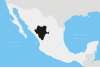
Tepehuanes Municipality is a municipality in the Mexican state of Durango. It is located in the North West of Durango at 25°12'"-26°25'"N 105°23'"-106°40'"W, at an elevation of about 1,830 meters (6000 feet).
Albertville is a village in the Canadian province of Saskatchewan within the Rural Municipality of Garden River No. 490 and is in Census Division No. 15. It is approximately 25 km northeast of the City of Prince Albert.
Santiago Papasquiaro is a city located in a valley situated on the eastern slopes of the Sierra Madre Occidental in the state of Durango, Mexico. As of 2010, the city of Santiago Papasquiaro had a population of 26,121, while the municipality has a census population of 48,482 as of 2015. It is the fourth largest community in the state in terms of population, and is the municipal seat of the municipality of the same name. The municipality has an area of 7,238.4 km².

Division No. 18, Saskatchewan, Canada, is one of the eighteen Statistics Canada census divisions within the province, occupying the northern half of the province. The census division is coextensive with the Northern Saskatchewan Administration District (NSAD).

The Nazas River is a river located in northern Mexico, in the states of Coahuila and Durango. It is part of the endorheic Bolsón de Mapimí. It is only 560 kilometres (350 mi) long, but irrigates an area of 71,906 km2 (27,763 sq mi) in the middle of the desert. The Nazas is also nurtured by the San Juan, Ramos, Potreritos, del Oro, Nazas, Santiago, Tepehuanes and Peñón Blanco rivers. The river starts at the Sierra Madre Occidental. The aboriginal title for this stream is Tlahualilo, coming from the Nahuatl words tlalli meaning "fertile land" and ahualila, meaning "water for irrigation".
Paddockwood is a village in the Canadian province of Saskatchewan within the Rural Municipality of Paddockwood No. 520 and Census Division No. 15. It was named after the town Paddock Wood in Kent, England.
Fresneña is a municipality located in the province of Burgos, Castile and León, Spain. According to the 2004 census (INE), the municipality has a population of 105 inhabitants.

Mitogen-activated protein kinase kinase kinase 11 is an enzyme that in humans is encoded by the MAP3K11 gene.

Disley is a village in the Canadian province of Saskatchewan within the Rural Municipality of Lumsden No. 189 and Census Division No. 6. It is located 18 km (11 mi) west of Lumsden just south of the Louis Riel Trail and 48 kilometres northwest of the City of Regina.
Pacific is a small unincorporated community in El Dorado County, California. It is located 3.25 miles (5 km) east of Pollock Pines, at an elevation of 3396 feet. It lies along U.S. Highway 50. The ZIP code is 95726. The community is inside area code 530.
Plunkett is a special service area in the Canadian province of Saskatchewan within the Rural Municipality of Viscount No. 341 and Census Division No. 11. It held village status between 1921 and 2022.
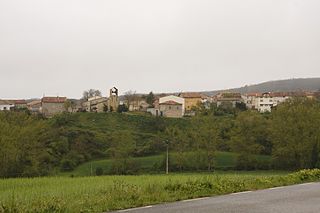
El Rincón is a town in the municipality of Tepehuanes of the State of Durango of Mexico.
San Bernardo is a city and seat of the municipality of San Bernardo in the state of Durango in Mexico. As of 2010, the town had a population of 700.
The 2011 Durango massacres were a series of mass murders that occurred in 2011. According to El Universal and Yahoo! News, at least 340 bodies have been found in mass graves around the city of Durango as of February 2012; These mass graves are the first of their kind in the state of Durango and third of their kind in Mexico. These mass graves had more bodies than the 2011 Tamaulipas massacre of 189 bus passengers. Since April 2011, there have been seven mass graves found around Durango. One of these mass graves was found in a vacant auto repair lot in Durango with 89 bodies. One of the bodies identified was Alfonso Peña, the former mayor of Tepehuanes Municipality, Durango.
Discovery Studio is a suite of software for simulating small molecule and macromolecule systems. It is developed and distributed by Dassault Systemes BIOVIA.
Readlyn is a hamlet in Excel Rural Municipality No. 71, Saskatchewan, Canada. It previously held the status of a village until December 31, 1955.

Willows is an unincorporated community in Lake of the Rivers Rural Municipality No. 72, Saskatchewan, Canada. It previously held the status of a village until January 1, 1950. The name is a contraction of William Gibson Lowes, owner of the first store.
Tepehuanes may refer to:
References
- ↑ Piña, Ma. Guadalupe Arzate, Ma. Soledad Martínez. "Catálogo Localidades". www.microrregiones.gob.mx.
{{cite web}}: CS1 maint: multiple names: authors list (link)
25°20′23″N105°43′28″W / 25.3396°N 105.7245°W
| | This article about a location in the Mexican state of Durango is a stub. You can help Wikipedia by expanding it. |