Southern California is a geographic and cultural region that generally comprises the southern portion of the U.S. state of California. It includes the Los Angeles metropolitan area, the second most populous urban agglomeration in the United States. The region generally contains ten of California's 58 counties: Imperial, Kern, Los Angeles, Orange, Riverside, San Bernardino, San Diego, Santa Barbara, San Luis Obispo and Ventura counties.

Santa Ana is the county seat of Orange County, California. Located in the Greater Los Angeles region of Southern California, the city's population was 310,227 at the 2020 census, making Santa Ana the second most populous city in Orange County, the 13th-most populous city in California, and the 64th densest large city in the United States. Santa Ana is a major regional economic and cultural hub for the Orange Coast.

San Jacinto Peak is a 10,834 ft (3,302 m) peak in the San Jacinto Mountains, in Riverside County, California. Lying within Mount San Jacinto State Park it is the highest both in the range and the county, and serves as the southern border of the San Gorgonio Pass. Naturalist John Muir wrote of San Jacinto Peak, "The view from San Jacinto is the most sublime spectacle to be found anywhere on this earth!"

The Santa Ana River is the largest river entirely within Southern California in the United States. It rises in the San Bernardino Mountains and flows for most of its length through San Bernardino and Riverside counties, before cutting through the northern Santa Ana Mountains via Santa Ana Canyon and flowing southwest through urban Orange County to drain into the Pacific Ocean. The Santa Ana River is 96 miles (154 km) long, and its drainage basin is 2,650 square miles (6,900 km2) in size.

San Gorgonio Mountain, also known locally as Mount San Gorgonio, or Old Greyback, is the highest peak in Southern California and the Transverse Ranges at 11,503 feet (3,506 m).

The Santa Ana Mountains are a short peninsular mountain range along the coast of Southern California in the United States. They extend for approximately 61 miles (98 km) southeast of the Los Angeles Basin largely along the border between Orange and Riverside counties.

The San Bernardino Mountains are a high and rugged mountain range in Southern California in the United States. Situated north and northeast of San Bernardino and spanning two California counties, the range tops out at 11,503 feet (3,506 m) at San Gorgonio Mountain – the tallest peak in all of Southern California. The San Bernardinos form a significant region of wilderness and are popular for hiking and skiing.

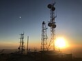
Mount Wilson is a peak in the San Gabriel Mountains, located within the San Gabriel Mountains National Monument and Angeles National Forest in Los Angeles County, California. With only minor topographical prominence the peak is not naturally noticeable from a distance, although it is easily identifiable due to the large number of antennas near its summit. It is a subsidiary peak of nearby San Gabriel Peak.

Cleveland National Forest encompasses 460,000 acres, mostly of chaparral, with a few riparian areas. A warm dry mediterranean climate prevails over the forest. It is the southernmost U.S. National Forest of California. It is administered by the U.S. Forest Service, a government agency within the United States Department of Agriculture. It is divided into the Descanso, Palomar and Trabuco Ranger Districts and is located in the counties of San Diego, Riverside, and Orange.
The Santiago Canyon Fire of 1889 was a massive wildfire in California, which burned large parts of Orange County, Riverside County, and San Diego County during the last week of September 1889. The fire reportedly started in Fremont Canyon, a canyon close to what today is Irvine Lake. Until 2018, it was possibly the single largest wildfire in the recorded history of California, with at least 300,000 acres (1,200 km2) of land burned. In mid-August 2018, the Ranch Fire in the Mendocino Complex Fire surpassed the Santiago Canyon Fire's assumed acreage.

Modjeska Peak is the northern mountain of the Saddleback landform in Orange County California. It is the second-highest peak of the Santa Ana Mountains, after Santiago Peak, whose summit is less than 0.6 mi (0.97 km) to the northwest. Modjeska lies within Cleveland National Forest and, despite being shorter than Santiago, has a smaller peak without manmade structures to obstruct views of the Pacific Ocean and San Gabriel Mountains.

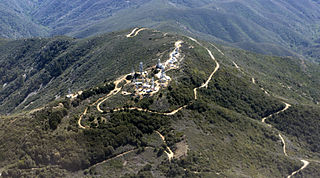
Mount Rubidoux is a mountain just west of downtown in the city of Riverside, California, United States, that has been designated a city park and landmark. The mountain was once a popular Southern California tourist destination and is still the site of the oldest outdoor non-denominational Easter Sunrise service in the United States. Many historic markers and memorials have been placed on the mountain, the most prominent being the cross at the summit dedicated to Father Junípero Serra. A majority of Mt. Rubidoux is owned by the City of Riverside, while 0.43 acres at the peak is owned by Rivers & Lands Conservancy after the cross attracted a potential lawsuit and the city decided to sell it at auction it to a private organization.
Santiago Canyon is a canyon and unincorporated community in South Orange County, California. According to the 2000 census, Santiago Canyon has several hundred residents living within its borders. Trabuco Canyon, Silverado Canyon, Modjeska Canyon and Williams Canyon are tributaries of Santiago Canyon. Santiago Creek flows northwest from the canyon, then west into the Santa Ana River. Neighborhoods in Santiago Canyon include Santiago Canyon Estates and Falcon View Estates. The landmark Cook's Corner motorcycle restaurant is also located within Santiago Canyon.

Arroyo Trabuco is a 22-mile (35 km)-long stream in coastal southern California in the United States. Rising in a rugged canyon in the Santa Ana Mountains of Orange County, the creek flows west and southwest before emptying into San Juan Creek in the city of San Juan Capistrano. Arroyo Trabuco's watershed drains 54 square miles (140 km2) of hilly, semi-arid land and lies mostly in Orange County, with a small portion extending northward into Riverside County. The lower section of the creek flows through three incorporated cities and is moderately polluted by urban and agricultural runoff.

Santiago Creek is a major watercourse in Orange County in the U.S. state of California. About 34 miles (55 km) long, it drains most of the northern Santa Ana Mountains and is a tributary to the Santa Ana River. It is one of the longest watercourses entirely within the county. The creek shares its name with Santiago Peak, at 5,687 ft (1,733 m) the highest point in Orange County, on whose slopes its headwaters rise.

Redonda Mesa is a mesa type formation located in the southern Santa Ana Mountains, near the Pacific Ocean in Southern California. It is located in an unincorporated area of southwestern Riverside County.

The geography of southern California refers to the geography of southern California in the United States.

Hot Spring Canyon is a drainage located in the Cleveland National Forest in the Orange, Riverside and San Diego counties of California. The mountainous region is known locally as the Santa Ana Mountains. The canyon is formed by Hot Spring Creek, a major tributary of San Juan Creek watershed. Hot Springs Creek is known for its many waterfalls and swimming holes.
Trabuco Peak is a 4,607-foot (1,404 m) summit in the Santa Ana Mountains on the border of Orange and Riverside Counties, California, about halfway between Rancho Santa Margarita and Lake Elsinore. The mountain sits on the divide between Arroyo Trabuco on the west and the Temescal Creek valley on the east. Situated in the Cleveland National Forest, it is the highest summit in the Santa Anas south of Santiago Peak.