Porto Alegre is the capital and largest city of the Brazilian state of Rio Grande do Sul. Its population of 1,488,252 inhabitants (2020) makes it the twelfth most populous city in the country and the center of Brazil's fifth largest metropolitan area, with 4,405,760 inhabitants (2010). The city is the southernmost capital city of a Brazilian state.

Rio Grande do Sul is a state in the southern region of Brazil. It is the fifth-most-populous state and the ninth largest by area. Located in the southernmost part of the country, Rio Grande do Sul is bordered clockwise by Santa Catarina to the north and northeast, the Atlantic Ocean to the east, the Uruguayan departments of Rocha, Treinta y Tres, Cerro Largo, Rivera and Artigas to the south and southwest, and the Argentine provinces of Corrientes and Misiones to the west and northwest. The capital and largest city is Porto Alegre. The state has the highest life expectancy in Brazil, and the crime rate is relatively low compared to the Brazilian national average. Despite the high standard of living, unemployment is still high in the state, as of 2017. The state has 5.4% of the Brazilian population and it is responsible for 6.6% of the Brazilian GDP.

Natal is the capital and largest city of the state of Rio Grande do Norte, located in northeastern Brazil. According to IBGE's 2021 estimate, the city had a total population of 896,708, making it the 19th largest city in the country. Natal is a major tourist destination and an exporting hub of crustaceans, carnauba wax and fruits, mostly melon, sugar apple, cashew and papaya. It is the country's closest city to Africa and Europe, with its Greater Natal International Airport connecting Natal with many Brazilian cities and also operating some international flights. The city was one of the host cities of the 2014 FIFA World Cup.

Salgado Filho Porto Alegre International Airport is the airport serving Porto Alegre and the region of Greater Porto Alegre, Brazil. It is named after the Senator and first Minister of the Brazilian Air Force Joaquim Pedro Salgado Filho (1888–1950).

Novo Hamburgo is a municipality in the southernmost Brazilian state of Rio Grande do Sul, located in the metropolitan area of Porto Alegre, the state capital. As of 2020, its population was 247,032. The city covers an area of 217 km2 (84 sq mi), and the average temperature is 19 °C (66 °F), which is mild for the region. The Sinos River runs through the urban area.

The Ragamuffin War was a Republican uprising that began in southern Brazil, in the province of Rio Grande do Sul in 1835. The rebels were led by generals Bento Gonçalves da Silva and Antônio de Sousa Neto with the support of the Italian fighter Giuseppe Garibaldi. The war ended with an agreement between the two sides known as Green Poncho Treaty in 1845.

Santa Maria is a municipality (município) in the central region of Rio Grande do Sul, the southernmost state of Brazil. In 2020, its population was 283,677 inhabitants in a total area of 1,823 square kilometres (704 sq mi). Santa Maria is the 5th biggest municipality in the state, and the largest in its micro-region.
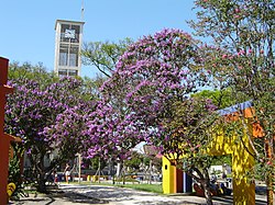
Gravataí is a Brazilian municipality near Porto Alegre at the Rio Grande do Sul State. Its population is approximately 280,000 people, making it the sixth most populous city in the state.

Unisinos is a Brazilian private Jesuit university founded in 1969. Its main campus is located in Southern Brazil, in the city of São Leopoldo, state of Rio Grande do Sul. Unisinos has more than 30,000 students in its 91 undergraduate programs, 19 academic master's programs, 6 professional master's programs, and 14 PhD programs, with six schools – Polytechnic, Business, Law, Health, Creative Industry, and Humanities.

Viamão is a city in Rio Grande do Sul, Brazil. In size it is the largest municipality in the metropolitan region of Porto Alegre and the seventh most populous in the state.
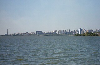
Lake Guaíba is a waterway in Rio Grande do Sul, the southernmost state of Brazil. It is famous for its beautiful reflection at sunset. The Guaíba is an extension of the Lagoa dos Patos, the largest lagoon in South America. It is commonly referred to as a "river" besides "lake". The Jacuí River, the Sinos River, the Gravataí River and the Caí River empties into the Guaíba from the north.

The Jacuí River is a river in Rio Grande do Sul state of southern Brazil. The Jacuí empties into the Guaíba River, an estuarine arm of the Lagoa dos Patos, a large coastal lagoon connected to the Atlantic Ocean.

The Porto Alegre Metro is a transit system operated jointly by the federal government, the state government of Rio Grande do Sul and the city of Porto Alegre through the company Trensurb in Brasil. It has 22 stations, totaling 43.8 kilometers (27.2 mi) of route, and carries about 175,000 users a day.
The Revolt of the Muckers was a conflict between two groups in a German community in Southern Brazil, in 1873 and 1874. It took place in the region of Sapiranga, Rio Grande do Sul, Brazil. Jacobina Mentz Maurer, believed by some to be a prophet, led a conflict that was eventually quelled by the Brazilian military, and its leaders either killed or arrested and imprisoned.

The Economy of Porto Alegre is the fastest growing economy in Brazil and is currently the country's 7th largest regional economy. The city of Porto Alegre has a population of approximately 1.4 million people. The history of Porto Alegre, particularly during the industrial revolution established its economy and the basis of the current industrial sector in the city.
Banhados do Delta do Jacuí Biological Reserve is a biological reserve in the Jacuí River delta in Rio Grande do Sul, Brazil.

Cidade Baixa is a neighborhood of the city of Porto Alegre, the state capital of Rio Grande do Sul in Brazil. The neighborhood was created by the law number 2022 of December 7, 1959.

Esporte Clube Cruzeiro, commonly referred to as Cruzeiro-RS, is a Brazilian football club based in Cachoeirinha, Rio Grande do Sul. It currently plays in Campeonato Gaúcho Série A2, the second level of the Rio Grande do Sul state football league.
Agronomia is a neighbourhood (bairro) in the city of Porto Alegre, the state capital of Rio Grande do Sul, Brazil. It was created by Law 4166 from September 21, 1976, but had its limits modified in 1990 and 1997.

Rio dos Sinos is a river in the state of Rio Grande do Sul, southern Brazil. It rises in the hills east of Caraá at elevations above 600 metres (2,000 ft) and covers a distance of about 190 kilometres (120 mi), flowing into the delta Jacuí in Canoas, at an elevation of only 5 metres (16 ft).