South Bruce Peninsula is a town at the base of the Bruce Peninsula of Ontario, Canada, in Bruce County between Lake Huron and Georgian Bay. It was formed on January 1, 1999, when the town of Wiarton, the village of Hepworth, and the townships of Albemarle and Amabel were amalgamated. This new municipality was created to provide necessary political representation, administrative support and necessary municipal services on behalf of the residents.

The Rouge River is a river in Markham, Pickering, Richmond Hill and Toronto in the Greater Toronto Area of Ontario, Canada. The river flows from the Oak Ridges Moraine to Lake Ontario at the eastern border of Toronto, and is the location of Rouge Park, the only national park in Canada within a municipality. At its southern end, the Rouge River is the boundary between Toronto and southwestern Pickering in the Regional Municipality of Durham.

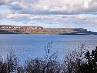
Bruce County is a county in Southwestern Ontario, Canada comprising eight lower-tier municipalities and with a 2016 population of 66,491. It is named for James Bruce, 8th Earl of Elgin and 12th Earl of Kincardine, sixth Governor General of the Province of Canada. The Bruce name is also linked to the Bruce Trail and the Bruce Peninsula. It has three distinct areas. The Peninsula is part of the Niagara Escarpment and is known for its views, rock formations, cliffs, and hiking trails. The Lakeshore includes nearly 100 km of fresh water and soft sandy beaches. Finally, the Interior Region has a strong history in farming.

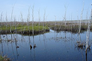
The Nottawasaga River is a river in Simcoe County and Dufferin County in Central Ontario, Canada. It is part of the Great Lakes Basin, and is a tributary of Lake Huron. The river flows from the Orangeville Reservoir in the town of Orangeville, Dufferin County, through the Niagara Escarpment and the Minesing Wetlands, the latter a wetland of international significance, and empties into Nottawasaga Bay, an inlet of Georgian Bay on Lake Huron, at the town of Wasaga Beach, Simcoe County.
The Raisin River is a river in South Stormont and South Glengarry, United Counties of Stormont, Dundas and Glengarry in eastern Ontario, Canada, with the watershed encompassing portions of North Stormont, North Glengarry and the city of Cornwall as well. It empties into Lake Saint Francis on the Saint Lawrence River near the community of Lancaster.
The Bighead River is a river in Grey County in southern Ontario, Canada, that flows from the Niagara Escarpment between the communities along Ontario Highway 10 of Arnott and Holland Centre in the township of Chatsworth to empty into Nottawasaga Bay, an inlet of Georgian Bay on Lake Huron, at Meaford.
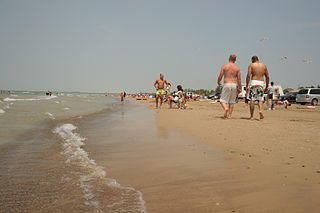
Sauble Beach is a beach community and unincorporated area in the town of South Bruce Peninsula, Bruce County, in the northern area of southwestern Ontario, Canada. It is on the Bruce Peninsula, along the eastern shore of Lake Huron, on the north edge of the Saugeen First Nation. The beach takes its name from that given by early French explorers to the sandy Sauble River, originally "La Rivière Au Sable" also indicating that the river emptied into Lake Huron at a sandy beach. The river was labelled with the French name on maps until 1881, when it became the Sauble River; in early years, a sawmill was built on the river, and later, a hydro electric plant.
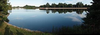
The Rankin River is a river in the town of South Bruce Peninsula, Bruce County in southwestern Ontario, Canada which flows from the east side of the Bruce Peninsula to join the Sauble River near Sauble Falls Provincial Park on the west side. The river is in the Lake Huron drainage basin and was named after Charles Rankin, who first surveyed the Bruce Peninsula.
The Bayfield River is a river in Huron and Perth Counties in southwestern Ontario, Canada, that empties into Lake Huron at the community of Bayfield in the municipality of Bluewater.

The Maitland River is a river in Huron County, Perth County and Wellington County in Southwestern Ontario, Canada. The river is in the Great Lakes Basin and empties into Lake Huron at the town of Goderich. It is 150 kilometres (93 mi) long, and is named after Sir Peregrine Maitland, Lieutenant-Governor of Upper Canada from 1818 to 1828. It was formerly known as the Menesetung River.
The Pottawatomi River is a river in the municipalities of Owen Sound and Georgian Bluffs, Grey County in Southwestern Ontario, Canada.It is in the Great Lakes Basin and empties into Owen Sound, an inlet of Georgian Bay on Lake Huron, at Owen Sound Harbour.
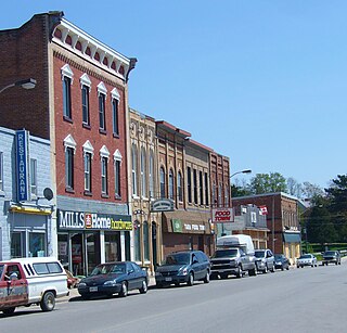
Tara is an unincorporated community in the municipality of Arran–Elderslie, Bruce County, in southwestern Ontario, Canada. It is a designated place and had 1,037 residents and 458 dwellings as of the 2011 census. Tara is in geographic Arran Township and is located on the Sauble River. It has an area of 2.39 square kilometres (0.92 sq mi) and an urban area that covers 63.5 square kilometres (24.5 sq mi).

The Municipality of Arran–Elderslie is a township in Bruce County in Western Ontario, Canada. The township is located at the headwaters of the Sauble River, and the Saugeen River forms the northwestern boundary.

Conservation Ontario is the umbrella organization which represents all of the conservation authorities in Ontario. This nonprofit organization was founded in 1980/81. Conservation Ontario is the network of 36 Conservation Authorities.

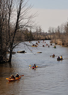
Sauble Falls Provincial Park is located in the town of South Bruce Peninsula, Bruce County in southwestern Ontario, Canada, 36 kilometres (22 mi) west of Owen Sound. It is in the lower drainage basin of the Sauble River, which flows into Lake Huron. The campground consists of two sections divided by County Road 13. The west section of the site is a quiet zone. Group camping is available in the east section. Many sites along the east portion of the park back up against the Sauble River. The park is also the downstream terminus of the Rankin River canoe route.
Silver Creek is a river in the municipality of Huron East, Huron County, Ontario, Canada and a right tributary of the Bayfield River.
Petticoat Creek is a stream in the cities of Pickering, Toronto and Markham in the Greater Toronto Area of Ontario, Canada. The creek is in the Great Lakes Basin, is a tributary of Lake Ontario, and falls under the auspices of the Toronto and Region Conservation Authority. Its watershed covers 26.77 square kilometres (10.34 sq mi), and the cumulative length of all its branches is 49 kilometres (30 mi). Land use in the watershed consists of 52% agricultural, 27% protected greenspace and 21% urban.
The Boyne River is a river in Simcoe County and Dufferin County in Central Ontario, Canada. It is part of the Great Lakes Basin, and is a left tributary of the Nottawasaga River. The rivers falls within the jurisdiction of the Nottawasaga Valley Conservation Authority.

The Beaver River is a river in Grey County and Simcoe County in Southern Ontario, Canada. It is part of the Great Lakes Basin, and is a tributary of Lake Huron. The river's drainage basin is under the auspices of Grey Sauble Conservation.

