Savage Mill Trail

Last updated
Savage Mill Trail
Walking along the Savage Mill Trail.jpg
The Savage Mill Trail heading west from the trailhead.
Length0.8 mi (1.3 km)
Location Savage Mill, Maryland
Trailheads Savage Mill
UseWalking, jogging, biking, fishing, kayaking, and cross-country skiing
Hiking details
SeasonYear-round
MonthsYear-round
Surface Asphalt, gravel, and dirt
Right of way Baltimore and Ohio Railroad

The Savage Mill Trail is a 0.8-mile (1.3 km) rail trail that winds along the Little Patuxent River in Savage, Maryland. The trail was formerly part of the Baltimore and Ohio Railroad's rail corridor through central Maryland, but the Howard County Recreation and Parks Department acquired the land in 1978.

Rail trail railroad bed converted to a recreational trail

A rail trail is the conversion of a disused railway track into a multi-use path, typically for walking, cycling and sometimes horse riding and snowmobiling. The characteristics of abandoned railways—flat, long, frequently running through historical areas—are appealing for various developments. The term sometimes also covers trails running alongside working railways; these are called "rails with trails". Some shared trails are segregated, with the segregation achieved with or without separation. Many rail trails are long-distance trails.

Savage, Maryland Census-designated place in Maryland, United States

Savage is an unincorporated community and census-designated place located in Howard County, Maryland, about 18 miles (29 km) south of Baltimore and 21 miles (34 km) north of Washington, D.C. It is situated close to the city of Laurel and to the planned community of Columbia. As of the 2010 census it had a population of 7,054. The former mill town is a registered historic place, and has many original buildings preserved within and around the Savage Mill Historic District.

Baltimore and Ohio Railroad former rail system in the United States of America

The Baltimore and Ohio Railroad was the first common carrier railroad and the oldest railroad in the United States, with its first section opening in 1830. It came into being mostly because the city of Baltimore wanted to compete with the newly constructed Erie Canal and another canal being proposed by Pennsylvania, which would have connected Philadelphia and Pittsburgh. At first this railroad was located entirely in the state of Maryland, with an original line built from the port of Baltimore west to Sandy Hook.

Contents

Historical development

Historical significance

The historic Bollman truss bridge was built in 1869 and is the last of its kind in the country. It is preserved as a National Historic Landmark and sits at the trailhead of the Savage Mill Trail Historic Bollman Truss Bridge.jpg
The historic Bollman truss bridge was built in 1869 and is the last of its kind in the country. It is preserved as a National Historic Landmark and sits at the trailhead of the Savage Mill Trail

The Savage Mill Trail is located in an area that became a major manufacturing center in the early 1800s. Near the beginning of the trail is a textile mill that was built between 1816 and 1823. This mill along with other manufacturing companies in the area utilized the currents of the Little and Middle Patuxent Rivers to power their factories.

At the beginning of the trail is a Bollman truss bridge, which was used by the Baltimore and Ohio Railroad during the middle of the 19th century. The Bollman truss bridge was invented in 1850 and was the first system to be made entirely of iron. This bridge was built in 1869 and is the only remaining Bollman truss bridge of its design in the country. It is now preserved as a National Historic Landmark.

During the American Civil War, Savage Mill served an important role for the Union Army beginning in 1861. Despite a limited supply of cotton, the mill was used to manufacture canvas for cannon covers and tents. In addition, the Baltimore and Ohio Railroad line to Savage Mill transported federal troops who occasionally camped in the meadow on the north side of the railroad.

American Civil War Civil war in the United States from 1861 to 1865

The American Civil War was a war fought in the United States from 1861 to 1865, between the North and the South. The Civil War is the most studied and written about episode in U.S. history. Primarily as a result of the long-standing controversy over the enslavement of black people, war broke out in April 1861 when secessionist forces attacked Fort Sumter in South Carolina shortly after Abraham Lincoln had been inaugurated as the President of the United States. The loyalists of the Union in the North proclaimed support for the Constitution. They faced secessionists of the Confederate States in the South, who advocated for states' rights to uphold slavery.

Union Army Land force that fought for the Union during the American Civil War

During the American Civil War, the Union Army referred to the United States Army, the land force that fought to preserve the Union of the collective states. Also known as the Federal Army, it proved essential to the preservation of the United States of America as a working, viable republic.

In 2014, the State of Maryland announced that funds were granted to design a bike trail from Savage through the busy Route One Corridor to North Laurel. The next day an 11-year-old boy was struck in a hit and run along the proposed route. [1] [2]

North Laurel, Maryland Census-designated place in Maryland

North Laurel is a census-designated place (CDP) in Howard County, Maryland, United States. The published population was 4,474 at the 2010 census. This population was substantially less than the CDP's population in 2000, and was the result of an error in defining the boundary prior to tabulation and publication of 2010 Census results. The corrected 2010 Census population is 20,259. North Laurel is adjacent to the City of Laurel, which is located across the Patuxent River in Prince George's County.

Trail's history and evolution

The Howard County Recreation and Parks Department acquired the Savage Mill Trail in 1978. At the time, the rails had all been torn up and the pathway was completely made of dirt. Rangers from the Parks Department covered a majority of the trail with gravel in 1980, and a fresh layer of gravel is added every eight to ten years. The trail has not undergone any significant extensions or renovations since it was acquired by the Parks Department.

Trail development

Design and construction

The Savage Mill Trail winds along the Little Patuxent River through the grounds of an old cotton mill. A majority of the trail is flat and covered with gravel, and it is accessible for wheel chairs, bikes, and strollers. Towards the end of the 1-mile trail it turns into dirt before ending abruptly in the middle of a forest. A majority of the trail is surrounded by trees on one side with views of the Little Patuxent River on the other. There are a couple of picnic tables and benches located along the path, and the trail averages about 10 feet in width.

Trail amenities

Parking for the Savage Mill Trail is located along Foundry Street, where up to twenty cars are able to fit. From Foundry Street, it is a very short walk to the start of the trail. Once on the trail, visitors can enjoy a picnic lunch at one of two picnic areas overlooking the Little Patuxent River. There are also five intervals along the trail where visitors can access the riverbank via sets of wooden stairs or small pathways.

Community

Trail supporters

The Savage Mill Trail is managed by the Howard County Recreation and Parks Department. The Parks Department is responsible for all maintenance and repairs of the trail. In addition, the Department provides four rangers per day during the summer to monitor visitor behavior and ensure that the trail is kept in quality condition.

Special events

There are several annual cleanups that occur along the Savage Mill Trail. Every April, members from Project Clean Stream come to the trail and clean up trash along the Little Patuxent River. Then in September, members from International Coastal Cleanup come to the trail and again clean up the area along the Little Patuxent River. Finally, members of the Johns Hopkins Applied Physics Lab host an annual trail cleanup in late October or early November.

In addition to trail cleanups, the Howard County Recreation and Parks Department is in the middle of its 5-year Maryland Amphibian and Reptile Atlas. Members of the local community are encouraged to hike Howard County trails, including the Savage Mill Trail, and take pictures of any nature that they find.

The Savage Mill Trail is also the location for occasional community group gatherings. Columbia Dogs on the Go, a local dog-walking group in Maryland, is one group that holds events for its members to walk their dogs along the trail.

Flora and fauna

There are ten notable bird species that inhabit the Savage Mill Trail. [3] Each of these birds can be spotted along the trail between March and May with the exception of the great egret, which can be found between August and November. These birds include:

Many visitors of the Savage Mill Trail utilize the adjacent Little Patuxent River to fish for trout and other species Fishing in the Patuxent River.jpg
Many visitors of the Savage Mill Trail utilize the adjacent Little Patuxent River to fish for trout and other species

In addition, there are four types of mammals that inhabit the Savage Mill Trail and are most often spotted during the warm months of the year:

Finally, the Little Patuxent River is home to over seven species of fish. The Parks Department stocks the river with trout during the first week of October, the last week of February, and the first week of March. Fishermen can expect to find the following fish when visiting the trail:

In addition to wildlife, the Savage Mill Trail is home to seven different types of trees. White and red oaks line a large part of the trail, but all of the trees include:

Related Research Articles

Laurel, Maryland City in Maryland, United States

Laurel is a city in northern Prince George's County, Maryland, in the United States, located almost midway between Washington, D.C., and Baltimore on the banks of the Patuxent River. Founded as a mill town in the early 19th century, the arrival of the Baltimore & Ohio Railroad in 1835 expanded local industry and later enabled the city to become an early commuter town for Washington and Baltimore workers. Largely residential today, the city maintains a historic district centered on its Main Street, highlighting its industrial past.

Patuxent River river in Maryland, USA

The Patuxent River is a tributary of the Chesapeake Bay in the state of Maryland. There are three main river drainages for central Maryland: the Potomac River to the west passing through Washington, D.C., the Patapsco River to the northeast passing through Baltimore, and the Patuxent River between the two. The 908-square-mile (2,352 km2) Patuxent watershed had a rapidly growing population of 590,769 in 2000. It is the largest and longest river entirely within Maryland, and its watershed is the largest completely within the state.

Guilford, Maryland Unincorporated community in Maryland, United States

Guilford is an unincorporated community located in Howard County in the state of Maryland in the United States. The location is named for the Guilford Mill. Guilford is near Kings Contrivance one of the nine "villages" of Columbia.

Kings Contrivance, Columbia, Maryland Village in Maryland, United States

Kings Contrivance is a village in the planned community of Columbia, Maryland, and is home to about 11,000 residents. It is Columbia's southernmost village, and was the eighth of Columbia's ten villages to be developed. Kings Contrivance consists of the neighborhoods of Macgill's Common, Huntington and Dickinson, and includes single-family homes, townhouses, apartments and a Village Center.

The Washington, Baltimore and Annapolis Trail (WB&A) is a 10.25-mile (16.50 km) long discontinuous rail trail from Lanham to Odenton in Maryland. Despite its name, it does not actually connect with Washington, D.C., Annapolis or Baltimore; its name is taken from the Washington, Baltimore and Annapolis Electric Railway, from which the right-of-way comes.

Bollman Truss Railroad Bridge

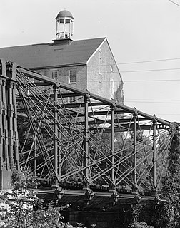
The Bollman Truss Railroad Bridge at Savage, Maryland is the sole surviving example of a revolutionary design in the history of American bridge engineering. The 160-foot (48.8 m) double-span truss bridge is one of the oldest standing iron railroad bridges in the United States. Currently, however, it is in use carrying the Savage Mill Trail across the Little Patuxent River. It was the first successful all-metal bridge design to be adopted and consistently used on a railroad. The type was named for its inventor, Wendel Bollman, a self-educated Baltimore civil engineer.

Wendel Bollman American civil engineer

Wendel Bollman was an American self-taught civil engineer, best known for his iron railway bridges. Only one of his patented "Bollman truss" bridges survives, the Bollman Truss Railroad Bridge in Savage, Maryland. The Wells Creek Bollman Bridge near Meyersdale, Pennsylvania is also standing, although that bridge uses the Warren truss system.

Patterson Viaduct

The Patterson Viaduct was built by the Baltimore and Ohio Railroad (B&O) as part of its Old Main Line during May to December 1829. The viaduct spanned the Patapsco River at Ilchester, Maryland. It was heavily damaged by a flood in 1866 and subsequently replaced with other structures.

Savage Mill shopping complex and historic cotton mill in Maryland, United States of America

The Savage Mill is a historic cotton mill complex in Savage, Maryland, which has been turned into a complex of shops and restaurants. It was placed on the National Register of Historic Places in 1974. It is located in the Savage Mill Historic District. Buildings in the complex date from 1822 to 1916.

New Germany State Park

New Germany State Park is a public recreation area covering 483 acres (195 ha) adjacent to Savage River State Forest in Garrett County, Maryland. The state park is administered by the Maryland Department of Natural Resources.

Rocky Gorge Reservoir

Rocky Gorge Reservoir is located on the Patuxent River in Howard County, Montgomery County and Prince George's County, Maryland between Laurel and Burtonsville, Maryland. The reservoir was created in 1952 by the construction of the T. Howard Duckett Dam on the Patuxent. The dam is visible from Interstate 95 near mile marker 34. Because of its close association with a dam by the name, the reservoir is sometimes called the T. Howard Duckett Reservoir. It has a surface area of 773 acres (3.13 km2). The reservoir is maintained as a drinking water source by the Washington Suburban Sanitary Commission (WSSC).

Lake Centennial (Maryland) manmade lake in Howard County, Maryland, United States

Centennial Lake is a man-made 54-acre (220,000 m2) reservoir, in a 325-acre (1.32 km2) park in Howard County, Maryland, near Columbia, Maryland and Clarksville, known as Centennial Park. It was created by damming the Centennial Branch of the Little Patuxent River. The lake and the park feature a dam, a wildlife area, a walking trail, boating, fishing, and other recreational activities. The park is owned by the Howard County Department of Recreation and Parks.

B & O Railroad Potomac River Crossing

The Baltimore and Ohio Railroad Crossings at the Potomac River are a set of railroad bridges that span the Potomac River between Maryland Heights, Maryland and Harpers Ferry, West Virginia in the United States.

Patuxent River State Park

Patuxent River State Park is a public recreation area located along the upper reaches of the Patuxent River in Howard and Montgomery counties in Maryland. The state park features hunting, fishing, mountain biking, horseback riding, and hiking on unsigned and untended trails. Planning for the park began in 1963, with the Maryland General Assembly funding land purchases in each year from 1964 to 1968. It is part of the Northeastern coastal forests ecoregion.

Savage River State Forest

Savage River State Forest is located in the north and northeastern part of Garrett County, in the U.S. state of Maryland. The state forest has many waterways, including Savage River Reservoir, which was built in 1952 by the U.S. Army. The dam was built as an emergency water supply for Washington, D.C. Savage River State Forest is known for its hunting, fishing, camping, and hiking trails.

Savage Mill Historic District

The Savage Mill Historic District is a national historic district located at Savage, Howard County, Maryland. The district comprises the industrial complex of Savage Mill and the village of workers' housing to the north of the complex.

Whiskey Bottom Road

Whiskey Bottom Road is a historic road north of Laurel, Maryland that traverses Anne Arundel and Howard Counties in an area that was first settled by English colonists in the mid-1600s. The road was named in the 1880s in association with one of its residents delivering whiskey after a prohibition vote. With increased residential development after World War II, it was designated a collector road in the 1960s; a community center and park are among the most recent roadside developments.

Middle Patuxent Environmental Area

The Middle Patuxent Environmental Area (MPEA) is a 1,021-acre (4.13 km2) wildlife area in Clarksville, Maryland and operated by the Howard County Department of Recreation and Parks. It is located next to the River Hill village in the town of Columbia, Maryland, in the United States. The MPEA was created in 1996 for educational, research, and recreational purposes.

References

  1. Luke Lavoie (5 September 2014). "Howard, Laurel granted state funds for bike path projects". The Baltimore Sun.
  2. Collin Campbell (6 September 2014). "11-year-old bicyclist injured in Laurel hit-and-run Anne Arundel police searching for old, red minivan with tinted windows". The Baltimore Sun.
  3. "Savage Mill Trail". Birding Howard County, Maryland. Retrieved 7 October 2011.

Coordinates: 39°8′4″N76°49′30.4″W / 39.13444°N 76.825111°W / 39.13444; -76.825111