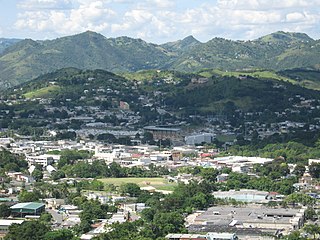
Cayey, officially Cayey de Muesas, is a mountain town and municipality in central Puerto Rico located on the Sierra de Cayey within the Central Mountain range, north of Salinas and Guayama; south of Cidra and Caguas; east of Aibonito and Salinas; and west of San Lorenzo. Cayey is spread over 21 barrios plus Cayey Pueblo. It is part of the San Juan-Caguas-Guaynabo Metropolitan Statistical Area.

Bayamón is a city, municipality of Puerto Rico and suburb of San Juan located in the northern coastal valley, north of Aguas Buenas and Comerío; south of Toa Baja and Cataño; west of Guaynabo; and east of Toa Alta and Naranjito. Bayamón is spread over 11 barrios and Bayamón Pueblo. It is part of the San Juan-Caguas-Guaynabo Metropolitan Statistical Area and the second most populous municipality in both the metropolitan area and Puerto Rico.

Salinas is a town and municipality in the southern part of Puerto Rico located in the southern coast of the island, south of Aibonito and Cayey; southeast of Coamo, east of Santa Isabel; and west of Guayama. Salinas is spread over 5 barrios and Salinas Pueblo.

Lares is a mountain town and municipality of Puerto Rico's central-western area. Lares is located north of Maricao and Yauco; south of Camuy, east of San Sebastián and Las Marias; and west of Hatillo, Utuado and Adjuntas. Lares is spread over 10 barrios and Lares Pueblo. It is part of the Aguadilla-Isabela-San Sebastián Metropolitan Statistical Area.

Ceiba is both a small town and a municipality in northeast Puerto Rico. It is named after the famous Ceiba tree. Ceiba is located in the north-east coast of the island, bordering the Atlantic Ocean, south of Fajardo, north of Naguabo and southeast of Río Grande. Located about one hour's driving distance from San Juan, Ceiba is spread over 7 barrios and Ceiba Pueblo. It is part of the Fajardo Metropolitan Statistical Area.

San Germán is a historic town and municipality located in the Sabana Grande Valley of southwestern region of Puerto Rico, south of Mayagüez and Maricao, north of Lajas, east of Hormigueros and Cabo Rojo, and west of Sabana Grande. San Germán is spread over eighteen barrios plus San Germán Pueblo. It is both a principal city of the San Germán–Cabo Rojo Metropolitan Statistical Area and the Mayagüez–San Germán–Cabo Rojo Combined Statistical Area. San Germán is the second oldest city of Puerto Rico, after San Juan, and its historic downtown is preserved as the San Germán Historic District.

Hormigueros is a town and municipality of Puerto Rico located in the western region of the island, northeast of Cabo Rojo; northwest of San Germán; and south of Mayagüez. Hormigueros is spread over 5 barrios and Hormigueros Pueblo. It is part of the Mayagüez Metropolitan Statistical Area.
Jayuya is a town and municipality of Puerto Rico located in the mountainous center region of the island, north of Ponce; east of Utuado; and west of Ciales. Jayuya is spread over 10 barrios and Jayuya Pueblo. It is the principal city of the Jayuya Micropolitan Statistical Area.
Juana Díaz is a town and municipality of Puerto Rico located in the southern coast of the island, south of Jayuya, Ciales, Orocovis and Villalba; east of Ponce; and west of Coamo and Santa Isabel and the Caribbean Sea to the south. Juana Díaz is spread over 13 barrios and Juana Diaz Pueblo. It is part of the Ponce Metropolitan Statistical Area.

Luquillo is a town and municipality of Puerto Rico located in the northeast coast, northwest of Fajardo; and east of Rio Grande. Luquillo is spread over 5 barrios and Luquillo Pueblo. It lends its name to the Sierra de Luquillo, where El Yunque National Forest is located. It is part of the Fajardo Metropolitan Statistical Area.

Moca is a town and municipality of Puerto Rico, located in the north-western region of the island, north of Añasco; southeast of Aguadilla; east of Aguada; and west of Isabela and San Sebastián. Moca is spread over 12 barrios and Moca Pueblo. It is part of the Aguadilla-Isabela-San Sebastián Metropolitan Statistical Area.

Patillas is a beach town and municipality of Puerto Rico located in the southeastern coast, south of San Lorenzo; west of Yabucoa and Maunabo; and east of Guayama and Arroyo. It is spread over 15 barrios and Patillas Pueblo. It is part of the Guayama Metropolitan Statistical Area.

Public housing in Puerto Rico is a subsidized system of housing units, mostly consisting of housing projects, which are provided for low-income families in Puerto Rico. The system is mainly financed with programs from the US Department of Housing and Urban Development (HUD) and the US Department of Agriculture USDA Rural Development. As of 2020, there were 325 public housing developments in Puerto Rico.

Anones is a barrio in the municipality of Naranjito, Puerto Rico. Its population in 2010 was 4,976. Anones is located to the South of the urban center of the municipality. There are schools and shops here and it is the most mountainous area of the municipality.

The Puerto Rico Department of Housing is the department responsible for homeownership, affordable housing, and community assistance programs in Puerto Rico. It was created in 1972.
The Secretary of Health of Puerto Rico leads the Department of Health of Puerto Rico and all efforts related to health in Puerto Rico.

Ponce Servicos, formerly Plaza del Mercado Juan Bigas, is a brutalist municipal building located Ponce, Puerto Rico. It is the largest building in the municipality in terms of footprint area and the only one that occupies an entire city block. The structure was built in 1981 as a way to provide a modern, air-conditioned, structure for the merchants and shoppers of the historic but aging Plaza de Mercado Isabel II building, while the latter underwent restoration. On its opening day it was named Plaza del Mercado Juan Bigas, in honor of Juan Bigas Moulins, the Ponce businessman by that name.

Calabazas is a barrio in the municipality of Yabucoa, Puerto Rico. Its population in 2010 was 7,675.
Mamey is a barrio in the municipality of Gurabo, Puerto Rico. Its population in 2010 was 4,714.

Sud is a barrio in the municipality of Cidra, Puerto Rico. Its population in 2010 was 3,714.