Sellersburg, Indiana

Last updated

Town of Sellersburg
Motto(s): 
"Proud of our past, in touch with the future" [1]
Clark County Indiana Incorporated and Unincorporated areas Sellersburg Highlighted 1868670.svg
Location of Sellersburg in Clark County, Indiana.
Coordinates: 38°23′13″N85°45′27″W / 38.38694°N 85.75750°W / 38.38694; -85.75750
Country United States
State Indiana
County Clark
Township Silver Creek
Government
  Type Town Council
  CouncilmenScott Mcvoy, Randall Mobley, Brad Amos, Terry Langford, Matthew Czarnecki [2]
  Town ManagerCharlie Smith [3]
Area
[4]
  Total7.47 sq mi (19.35 km2)
  Land7.41 sq mi (19.20 km2)
  Water0.06 sq mi (0.16 km2)
Elevation
[5]
515 ft (157 m)
Population
 (2020)
  Total9,310
  Density1,256.24/sq mi (485.01/km2)
Time zone UTC-5 (Eastern (EST))
  Summer (DST) UTC-4 (EDT)
ZIP code
47172
Area code(s) 812 & 930
FIPS code 18-68670 [6]
GNIS feature ID2396911 [5]
Website

Sellersburg is a town located within Silver Creek Township, Clark County, Indiana, United States. It had a population of 9,310 at the time of the 2020 census. Sellersburg is located along Interstate 65, about 15 minutes north of Louisville.

Contents

History

Sellersburg takes its name from its founder, Moses Sellers, who laid out the town in 1846. [7] [8] Sellersburg was incorporated in 1890. [1] The first post office at Sellersburg was established in 1854, at which time the name was spelled Sellersburgh. [9]

Silver Creek High School's boys' basketball team won the 2019 and 2021 IHSAA 3-A state championships. [10]

Geography

According to the 2010 census, Sellersburg has a total area of 7.47 square miles (19.35 km2), of which 7.41 square miles (19.19 km2) (or 99.19%) is land and 0.06 square miles (0.16 km2) (or 0.8%) is water. [11]

Demographics

Historical population
CensusPop.Note
1880 169
1890 508200.6%
1900 76149.8%
1910 676−11.2%
1920 91535.4%
1930 1,05014.8%
1940 1,1216.8%
1950 1,66448.4%
1960 2,67961.0%
1970 3,17718.6%
1980 3,2111.1%
1990 5,74578.9%
2000 6,0715.7%
2010 6,1280.9%
2020 9,31051.9%
U.S. Decennial Census [12]

2010 census

As of the census [13] of 2010, there were 6,128 people, 2,443 households, and 1,697 families living in the town. The population density was 1,555.3 inhabitants per square mile (600.5/km2). There were 2,595 housing units at an average density of 658.6 per square mile (254.3/km2). The racial makeup of the town was 94.2% White, 0.8% African American, 0.3% Native American, 0.3% Asian, 2.9% from other races, and 1.6% from two or more races. Hispanic or Latino of any race were 5.5% of the population.

There were 2,443 households, of which 33.7% had children under the age of 18 living with them, 50.6% were married couples living together, 13.2% had a female householder with no husband present, 5.6% had a male householder with no wife present, and 30.5% were non-families. 26.2% of all households were made up of individuals, and 10.4% had someone living alone who was 65 years of age or older. The average household size was 2.48 and the average family size was 2.96.

The median age in the town was 38 years. 24.6% of residents were under the age of 18; 8.3% were between the ages of 18 and 24; 26.1% were from 25 to 44; 26.4% were from 45 to 64; and 14.7% were 65 years of age or older. The gender makeup of the town was 48.6% male and 51.4% female.

2000 census

As of the census [6] of 2000, there were 6,072 people, 2,407 households, and 1,757 families living in the town. The population density was 1,515.8 inhabitants per square mile (585.3/km2). There were 2,535 housing units at an average density of 632.9 per square mile (244.4/km2). The racial makeup of the town was 98.48% White, 1.04% Hispanic or Latino of any race, 0.28% Native American, 0.25% African American, 0.16% Asian, 0.02% Pacific Islander, 0.28% from other races, and 0.53% from two or more races.

There were 2,407 households, out of which 33.0% had children under the age of 18 living with them, 57.0% were married couples living together, 11.8% had a female householder with no husband present, and 27.0% were non-families. 23.3% of all households were made up of individuals, and 7.2% had someone living alone who was 65 years of age or older. The average household size was 2.50 and the average family size was 2.92.

In the town, the population was spread out, with 24.5% under the age of 18, 8.4% from 18 to 24, 30.8% from 25 to 44, 23.4% from 45 to 64, and 12.8% who were 65 years of age or older. The median age was 37 years. For every 100 females, there were 92.6 males. For every 100 females age 18 and over, there were 89.3 males.

The median income for a household in the town was $39,832, and the median income for a family was $46,512. Males had a median income of $30,977 versus $21,974 for females. The per capita income for the town was $18,648. About 4.1% of families and 5.3% of the population were below the poverty line, including 8.2% of those under age 18 and 2.6% of those age 65 or over.

Education

Silver Creek School Corporation operates a primary, elementary, middle, and high school in Sellersburg. [14]

Silver Creek School Corporation was created after the West Clark Community School board voted unanimously to permit the divorce of Silver Creek schools from the district on November 9, 2017. [15]

Sellersburg has a public library, a branch of the Charlestown-Clark County Public Library. [16] A campus of Ivy Tech Community College is also located in Sellersburg.

Politics

In December 2021, local residents of Sellersburg formed a grassroots political movement called "Keep Sellersburg Small" in response to rapid growth, commercialization, and development of multi-family housing in the area. [17] Many residents have complained about excessive traffic due to these issues and have called on the Town Council of Sellersburg [2] to limit the growth.

Infrastructure

Transportation

In the early 1980s the Clark Regional Airport was constructed, a regional airport supporting small and mid-size aircraft.

Notable people

Related Research Articles

<span class="mw-page-title-main">Charlestown, Indiana</span> City in Indiana, United States

Charlestown is a city located within Charlestown Township, in Clark County, Indiana, United States. The population was 7,775 at the 2020 census.

<span class="mw-page-title-main">Converse, Indiana</span> Town in Indiana, United States

Converse is a town in Jackson Township, Miami County, and Richland Township, Grant County, in the U.S. state of Indiana. The population was 1,161 at the 2020 census.

<span class="mw-page-title-main">Cicero, Indiana</span> Town in Indiana, United States

Cicero is a town in Jackson Township, Hamilton County, Indiana, United States, north of Indianapolis. The population was 4,812 at the 2010 census.

<span class="mw-page-title-main">New Palestine, Indiana</span> Town in Indiana, United States

New Palestine is a town in Sugar Creek Township, Hancock County, Indiana, along Sugar Creek. The population was 2,055 at the 2010 census.

<span class="mw-page-title-main">Amo, Indiana</span> Town in Indiana, United States

Amo is a town in Clay Township, Hendricks County, Indiana, United States. The population was 408 at the 2020 census.

<span class="mw-page-title-main">Danville, Indiana</span> Town in Indiana, United States

Danville is a town in and the county seat of Hendricks County, Indiana, United States. The population was 9,001 at the 2010 census, up from 6,418 at the 2000 census. In 2019 the estimated population was 10,126.

<span class="mw-page-title-main">Stilesville, Indiana</span> Town in Indiana, United States

Stilesville is a town in Franklin Township, Hendricks County, Indiana, United States. The population was 316 at the 2010 Census.

<span class="mw-page-title-main">Brooksburg, Indiana</span> Town in Indiana, United States

Brooksburg is a town in Milton Township, Jefferson County, Indiana, United States. The population was 81 at the 2010 census.

<span class="mw-page-title-main">New Whiteland, Indiana</span> Town in Indiana, United States

New Whiteland is a town in Pleasant Township, Johnson County, Indiana, United States. The population was 5,550 at the 2020 census.

<span class="mw-page-title-main">Whiteland, Indiana</span> Town in Indiana, United States

Whiteland is a town in Pleasant, Franklin and Clark townships, Johnson County, Indiana, United States. The population was 4,599 at the 2020 census.

<span class="mw-page-title-main">Silver Lake, Indiana</span> Town in Indiana, United States

Silver Lake is a town in Lake Township, Kosciusko County, in the U.S. state of Indiana. The population was 915 at the 2010 census.

<span class="mw-page-title-main">Syracuse, Indiana</span> Town in Indiana, United States

Syracuse is a town in Turkey Creek Township, Kosciusko County, in the U.S. state of Indiana. The population was 3,079 at the 2020 census. Syracuse is the location of Lake Syracuse and the nearby, larger Lake Wawasee, in addition to several other lakes in the region. The National Weather Service operates a Weather Forecast Office South of town, toward North Webster. It serves Northern Indiana, Northwestern Ohio and Southwestern Michigan.

<span class="mw-page-title-main">Lapel, Indiana</span> Town in Indiana, United States

Lapel is a town in Stony Creek and Green townships, Madison County, Indiana, United States. It is part of the Indianapolis–Carmel–Anderson metropolitan statistical area. The population was 2,325 at the 2020 census, up from 2,068 in 2010.

<span class="mw-page-title-main">Summitville, Indiana</span> Town in Indiana, United States

Summitville is a town in Van Buren Township, Madison County, Indiana, United States. It is part of the Indianapolis–Carmel–Anderson metropolitan statistical area. The population was 989 at the 2020 census.

<span class="mw-page-title-main">Bunker Hill, Indiana</span> Town in Indiana, United States

Bunker Hill is a town in Pipe Creek Township, Miami County, in the U.S. state of Indiana. The population was 814 at the 2020 census, down from 888 in 2010.

<span class="mw-page-title-main">Ladoga, Indiana</span> Town in Indiana, United States

Ladoga is a town in Clark Township, Montgomery County, in the U.S. state of Indiana. The population was 1,081 at the 2020 census, up from 985 in 2010.

<span class="mw-page-title-main">Waynetown, Indiana</span> Town in Indiana, United States

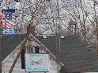
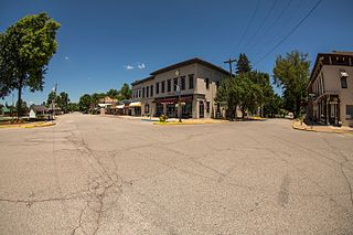
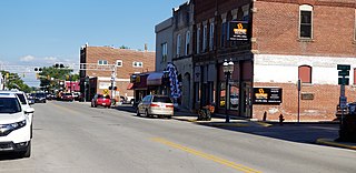
Waynetown is a town in Wayne Township, Montgomery County, in the U.S. state of Indiana. The population was 960 at the 2020 census.

<span class="mw-page-title-main">Mecca, Indiana</span> Town in Indiana, United States

Mecca is a town in Wabash Township, Parke County, in the U.S. state of Indiana. The population was 335 at the 2010 census.

<span class="mw-page-title-main">Osceola, Indiana</span> Town in Indiana, United States

Osceola is a town in Penn Township, St. Joseph County, in the U.S. state of Indiana. The population was 2,463 at the 2010 Census. It is part of the South Bend–Mishawaka, IN-MI, Metropolitan Statistical Area.

<span class="mw-page-title-main">Rogue River, Oregon</span> City in Oregon, United States

Rogue River is a city in Jackson County, Oregon, United States. As of the 2020 census the population was 2,407.

References

  1. 1 2 "Sellersburg Indiana". Sellersburg Indiana. Retrieved September 29, 2012.
  2. 1 2 "Town Council". sellersburg.org. Archived from the original on January 29, 2023. Retrieved July 20, 2023.
  3. "Sellesburg Town Administration".
  4. "2020 U.S. Gazetteer Files". United States Census Bureau. Retrieved March 16, 2022.
  5. 1 2 U.S. Geological Survey Geographic Names Information System: Sellersburg, Indiana
  6. 1 2 "U.S. Census website". United States Census Bureau . Retrieved January 31, 2008.
  7. Biographical and Historical Souvenir for the Counties of Clark, Crawford, Harrison, Floyd, Jefferson, Jennings, Scott, and Washington, Indiana. Chicago Printing Company. 1889. pp.  26.
  8. "Profile for Sellersburg, Indiana, IN". ePodunk. Retrieved September 29, 2012.
  9. "Clark County". Jim Forte Postal History. Retrieved August 30, 2014.
  10. "Silver Creek boys basketball wins second state championship". www.wdrb.com. Louisville, Kentucky. April 3, 2021. Archived from the original on April 3, 2021. Retrieved July 21, 2023.
  11. "G001 - Geographic Identifiers - 2010 Census Summary File 1". United States Census Bureau. Archived from the original on February 13, 2020. Retrieved July 25, 2015.
  12. "Census of Population and Housing". Census.gov. Retrieved June 4, 2015.
  13. "U.S. Census website". United States Census Bureau . Retrieved December 11, 2012.
  14. "Silver Creek School Corporation". www.scsc.school. Archived from the original on February 25, 2021. Retrieved July 24, 2023.
  15. Sayers, Justin (November 10, 2017). "West Clark heads into 'uncharted territory' after vote to secede Silver Creek schools". Courier Journal . Retrieved July 23, 2023.
  16. "Locations". Charlestown-Clark County Public Library. Archived from the original on March 4, 2018. Retrieved March 4, 2018.
  17. Schipper, Joel (January 29, 2022). "Grassroots effort begins to 'Keep Sellersburg small'". www.wdrb.com. Archived from the original on January 30, 2022. Retrieved July 22, 2023.