
Angel Mounds State Historic Site, an expression of the Mississippian culture, is an archaeological site managed by the Indiana State Museum and Historic Sites that includes more than 600 acres of land about 8 miles (13 km) southeast of present-day Evansville, in Vanderburgh and Warrick counties in Indiana. The large residential and agricultural community was constructed and inhabited from AD 1100 to AD 1450, and served as the political, cultural, and economic center of the Angel chiefdom. It extended within 120 miles (190 km) of the Ohio River valley to the Green River in present-day Kentucky. The town had as many as 1,000 inhabitants at its peak, and included a complex of thirteen earthen mounds, hundreds of home sites, a palisade (stockade), and other structures.

Wickliffe Mounds is a prehistoric, Mississippian culture archaeological site located in Ballard County, Kentucky, just outside the town of Wickliffe, about 3 miles (4.8 km) from the confluence of the Ohio and Mississippi rivers. Archaeological investigations have linked the site with others along the Ohio River in Illinois and Kentucky as part of the Angel Phase of Mississippian culture. Wickliffe Mounds is controlled by the State Parks Service, which operates a museum at the site for interpretation of the ancient community. Listed on the National Register of Historic Places, it is also a Kentucky Archeological Landmark and State Historic Site.

Moundville Archaeological Site, also known as the Moundville Archaeological Park, is a Mississippian culture archaeological site on the Black Warrior River in Hale County, near the modern city of Tuscaloosa, Alabama. Extensive archaeological investigation has shown that the site was the political and ceremonial center of a regionally organized Mississippian culture chiefdom polity between the 11th and 16th centuries. The archaeological park portion of the site is administered by the University of Alabama Museums and encompasses 185 acres (75 ha), consisting of 29 platform mounds around a rectangular plaza.
Indian Mound Park, also known as Shell Mound Park or Indian Shell Mound Park, is a park and bird refuge located on the northern shore of Dauphin Island, a barrier island of Mobile County, Alabama in the United States. In addition to the many birds which visit, a wide variety of botanical species contribute to the natural offerings. The site is historically significant due to the presence of prehistoric Indian shell middens, mounds composed of discarded oyster shells. The park was added to the National Register of Historic Places on August 14, 1973. It is administered by the Alabama Department of Conservation and Natural Resources.

The Stanfield-Worley Bluff Shelter, located on private property in Colbert County in northwestern Alabama, United States, is one of the most important prehistoric sites excavated in the state due to the archeological evidence deposited by the Paleo-Indians who once occupied the rock shelter. Lying in Sanderson Cove along a tributary of Cane Creek approximately seven miles (11 km) south of the Tennessee Valley, the shelter and the high bluffs of the surrounding valley provided a well-protected environment for the Native American occupants.

The State Line Archeological District is a complex of archaeological sites and national historic district located west of Elizabethtown, Ohio, United States. Located on both sides of the Indiana/Ohio border, the historic district is composed of five contributing properties spread out across 8 acres (3.2 ha) of land. It is believed to have been the site of a village of the Fort Ancient culture of prehistoric Native Americans.

The Nodena Site is an archeological site east of Wilson, Arkansas and northeast of Reverie, Tennessee in Mississippi County, Arkansas, United States. Around 1400–1650 CE an aboriginal palisaded village existed in the Nodena area on a meander bend of the Mississippi River. The Nodena site was discovered and first documented by Dr. James K. Hampson, archaeologist and owner of the plantation on which the Nodena site is located. Artifacts from this site are on display in the Hampson Museum State Park in Wilson, Arkansas. The Nodena Site is the type site for the Nodena Phase, believed by many archaeologists to be the province of Pacaha visited by Spanish explorer Hernando de Soto in 1542.

Bottle Creek Indian Mounds (1BA2) is an archaeological site owned and monitored by the Alabama Historical Commission located on a low swampy island within the Mobile-Tensaw River Delta north of Mobile, Alabama, United States. It was occupied by the peoples of the Pensacola culture, a regional Mississippian culture variant, and is the largest site of the Mississippian culture on the central Gulf Coast. It is important to understanding the history and culture of the Mobile-Tensaw delta in late prehistoric times and was designated as a National Historic Landmark on March 10, 1995, making it one of only two such sites in Alabama.
Jaketown Site is an archaeological site with two prehistoric earthwork mounds in Humphreys County, Mississippi, United States. While the mounds have not been excavated, distinctive pottery sherds found in the area lead scholars to date the mounds' construction and use to the Mississippian culture period, roughly 1100 CE to 1500 CE.
The Green River Shell Middens Archeological District is a historic district composed of archaeological sites in the U.S. state of Kentucky. All of the district's sites are shell middens along the banks of the Green River that date from the later portion of the Archaic period. Studies of this assemblage of sites were critical in the development of knowledge of the Archaic period in the eastern United States.
David G. Anderson is an archaeologist in the department of anthropology at the University of Tennessee, Knoxville, who specializes in Southeastern archaeology. His professional interests include climate change and human response, exploring the development of cultural complexity in Eastern North America, maintaining and improving the nation's Cultural Resource management (CRM) program, teaching and writing about archaeology, and developing technical and popular syntheses of archaeological research. He is the project director of the on-line Paleoindian Database of the Americas (PIDBA). and a Co-Director, with Joshua J. Wells, Eric C, Kansa, and Sarah Whitcher Kansa, of the Digital Index of North American Archaeology (DINAA)

Towosahgy State Historic Site (23MI2), also known as Beckwith's Fort Archeological Site, is a large Mississippian archaeological site with a Woodland period Baytown culture component located in Mississippi County, Missouri. It is believed to have been inhabited from c. 400-1350. The site is maintained by the Missouri Department of Natural Resources as a state historic site. The name Towosahgy is an Osage word which means "old town." It is not known if members of the historic Osage, who dominated a large area of present-day Missouri at the beginning of encounter with European colonizers, occupied the site. The site was acquired by the Missouri state park system in 1967 and added to the National Register of Historic Places in 1969 as NRIS number 69000113,

The C.H. Nash Museum at Chucalissa is located on and exhibits excavated materials of the Mississippian culture archaeological site known as Chucalissa which means "abandoned house" in Choctaw. The site is located adjacent to the T. O. Fuller State Park within the city of Memphis, Tennessee, United States. Chucalissa was designated National Historic Landmark in 1994 due to its importance as one of the best-preserved and major prehistoric settlement sites in the region.
Bussell Island, formerly Lenoir Island, is an island located at the mouth of the Little Tennessee River, at its confluence with the Tennessee River in Loudon County, near the U.S. city of Lenoir City, Tennessee. The island was inhabited by various Native American cultures for thousands of years before the arrival of early European explorers. The Tellico Dam and a recreational area occupy part of the island. Part of the island was added in 1978 to the National Register of Historic Places for its archaeological potential.

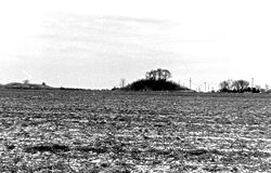
The Murphy Mound Archeological Site, is a prehistoric archaeological site in the Bootheel region of the U.S. state of Missouri. Located southwest of Caruthersville in Pemiscot County, Missouri the site was occupied by peoples of the Late Mississippian period, centuries before European colonization of the area.

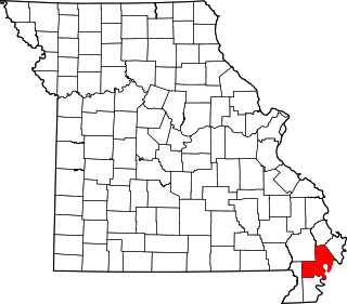
This is a list of the National Register of Historic Places listings in Mississippi County, Missouri.
This is a list of the National Register of Historic Places listings in New Madrid County, Missouri.
The Rock Creek Archeological District is a pair of archaeological sites near Maud, Colbert County, Alabama. The sites contain remnants from the Archaic, Gulf Formational, Woodland, and Mississippian Periods. One of the sites, ACt 44, shows evidence of two major habitations, a hunting camp from the Late Archaic period and a Late Mississippian farm village, although ceramics and arrowheads from other eras have also been recovered. Most artifacts from the other site, ACt 45, date from the Gulf Formational period. The sites were discovered by National Park Service archaeologist A. Wayne Prokopetz in 1975, with major surveys being completed by Christopher E. Hamilton in 1977 and by Memphis State University researchers in 1980. The district was listed on the National Register of Historic Places in 1990.
The Schilling Archeological District is a prehistoric Native American archaeological site on private property on Lower Grey Cloud Island in Cottage Grove, Minnesota, United States. It consists of a habitation site and mound group with artifacts that date from the Early Woodland Period to the Late Prehistoric Period. It was listed on the National Register of Historic Places in 1978 for having state-level significance in the theme of archaeology. It was nominated for its rare Early Woodland component, Middle Mississippian cultural influences, and potential to show climatic adaptations over time.


