"Shamokin" /ʃəˈmoʊkɪn/, or "Shahëmokink" in the Delaware language,[5] and Schahamokink in another Algonquian language, means "place of eels." The borough name is also derived from a 10-foot-tall (3.0m) dam that was built across the Susquehanna River in the 19th century. The dam supported steamboat ferries run by Ira T. Clement, which transported goods and people between Shamokin Dam and the city of Sunbury on the Northumberland County side of the river. These ferries operated from 1772 until the Bainbridge Street Bridge was built in 1907. The dam also provided water to the Susquehanna Division of the Pennsylvania Canal System, which was constructed on the western bank of the river. The dam was destroyed by ice in March 1904. Shamokin Dam is distinct from the city of Shamokin, Pennsylvania, which is located to the east.
Geography
Railroads off E. 8th Ave in Shamokin Dam
According to the United States Census Bureau, the borough has a total area of 1.9 square miles (4.9km2), of which 1.8 square miles (4.7km2) is land and 0.1 square miles (0.26km2) (2.66%) is water.
Shamokin Dam sits on the western bank of the Susquehanna River, just south of the confluence of the river's west and north branches. The borough is also bordered by the community of Hummels Wharf, Monroe Township, and U.S. Route 15.
There are several small, unnamed creeks that cross the borough, eventually draining into the Susquehanna River. Seasonal flooding occurs in the lowlands between the rail line and the river where the canal once passed. Some areas of the borough lie in the 100 year flood plain.
For many years, addresses in Shamokin Dam were listed under the same ZIP code as Selinsgrove, which was 17870. This led to confusion by delivery companies, emergency services and visitors to the region. Additionally, tax funding that should have gone to Shamokin Dam was lost. The implementation of the GIS readdressing program required that several local communities rename streets so that there were no redundancies within the Selinsgrove ZIP code. This prompted Shamokin Dam officials to appeal to the United States Postal Service for a unique ZIP code, which was awarded. Shamokin Dam addresses then became 17876.[6]
A large population of Delaware Indians was forcibly resettled in the area in the early 18th century after they lost rights to their land in the Walking Purchase. Canasatego of the Six Nations, enforcing the Walking Purchase of behalf of George Thomas, Deputy Governor of Pennsylvania, ordered the Delaware Indians to go to two places on the Susquehanna River, one of which was an area that included both present-day Sunbury, Pennsylvania and Shamokin Dam.[7]
From 1727 to 1756, the village of Shamokin was one of the largest and most influential Indian settlements in Pennsylvania.[7] In 1745, Presbyterian missionary David Brainerd described the city as being located on both the east and west sides of the river, and on an island, as well. Brainerd reported that the city housed 300 Indians, half of which were Delawares and the other Seneca and Tutelo.[8]
In 1754, much of the land west of the Susquehanna was transferred from the Six Nations to Pennsylvania at the Albany Congress. However, Shamokin was not sold and was reserved by the Six Nations, "to settle such of our Nations as shall come to us from the Ohio or any others who shall deserve to be in our Alliance."[9] According to Weslager, "the Pennsylvania authorities had no opposition to the Six Nations reserving Wyoming and Shamokin from the sale, since friendly Delawares, including Teedyuskung (also known as Teedyuscung) and his people living in those settlements--and any other Indians who might be placed there--constituted a buffer against Connecticut."[9]
The French and Indian War brought fighting to much of the region. The Delaware Indian residents of Shamokin remained neutral for much of the early part of the war, in part because a drought and unseasonable frost in Shamokin in 1755 left them without provisions.[10] However, the Delaware Indians at Shamokin joined the war against Pennsylvania and the English after the Gnadenhutten massacre in 1755.[11] Pennsylvania Fort Augusta was built in 1756 at Shamokin. Read more about early history of Shamokin in Shamokin (village).
Shikellamy, of the Oneida people, came to the region. He negotiated with the white settlers on behalf of the native residents. In 1754, Chief Shikellamy negotiated with Conrad Weiser to set the Blue Mountains as the upper limit settlement in the native people's home lands. Weiser told the area's settlers they could not remain. The Six Nations Treaty of 1754 permitted settlements to move west of the Susquehanna River into lands that eventually became Snyder County. Many natives argued they had been cheated by the treaty. Conflicts between the settlers and the native peoples resulted in deaths on both sides. Eventually, the native peoples were pushed out by the white settlers after the French and Indian War.
Germans were among the first European settlers in the region. Their influence continues today in the presence of the Amish and Mennonite sects.
Shamokin Dam was founded by George Keen in 1745. At the time it was named Keensville. Most of the residents were canal workers, raftsmen, shad fishermen and eel fishermen. Restaurants and hotels provided support for the workers and travelers. A lock for the Pennsylvania Canal was located on the riverbank. Most of the local commerce revolved around transportation and supporting the canal.[12]
In 1907 a toll bridge was completed that connected Shamokin Dam to Sunbury the county seat of Northumberland County. The cost for construction was $150,000. A full-time toll collector lived in the house that straddled the bridge. A gate closed the bridge at night. A bell was posted to summon the toll worker during the night. The bridge was used by pedestrians, buggies and motor cars. The toll was 3 cents for walkers, 4 cents for bicyclists, with 15 cents for horses, buggies and motor cars.[13]
As of the census[15] of 2000, there were 1,502 people, 688 households, and 436 families residing in the borough. The population density was 821.7 inhabitants per square mile (317.3/km2). There were 726 housing units at an average density of 397.2 per square mile (153.4/km2). The racial makeup of the borough was 97.94% White, 0.60% African American, 0.13% Native American, 0.80% Asian, 0.33% from other races, and 0.20% from two or more races. Hispanic or Latino of any race were 0.87% of the population.
There were 688 households, out of which 23.0% had children under the age of 18 living with them, 53.9% were married couples living together, 6.8% had a female householder with no husband present, and 36.5% were non-families. 33.7% of all households were made up of individuals, and 21.5% had someone living alone who was 65 years of age or older. The average household size was 2.18 and the average family size was 2.76.
In the borough the population was spread out, with 19.8% under the age of 18, 4.7% from 18 to 24, 24.6% from 25 to 44, 22.2% from 45 to 64, and 28.7% who were 65 years of age or older. The median age was 46 years. For every 100 females, there were 84.1 males. For every 100 females age 18 and over, there were 81.1 males.
The median income for a household in the borough was $34,514, and the median income for a family was $45,461. Males had a median income of $31,711 versus $21,917 for females. The per capita income for the borough was $19,923. About 3.9% of families and 8.4% of the population were below the poverty line, including 10.6% of those under age 18 and 12.2% of those age 65 or over.
Economics
The coal fired Sunbury power plant was commissioned by the PPL Corporation company in 1949. It went into operation in 1953. Sunbury Generation Station is located along the Susquehanna River in Shamokin Dam, Pennsylvania. The plant was purchased by WPS Power Development in November 1999 from PP&L Resources. The plant is part of the Pennsylvania/New Jersey/Maryland (PJM) market area. Power from the plant is sold into Pennsylvania's deregulated electric market. In May 2005, the facility's emission allowances for both sulfur dioxide (SO2) and nitrogen oxides (NOX) were sold and a seasonal operation plan was announced. Then in July 2006 the plant was sold to Corona Power, LLC. The gross proceeds received by WPS for the 421.7 megawatt power plant were about $34.6 million, and were subject to certain working capital and other post-closing adjustments. In 2006, Corona Power, LLC sought and won a substantial reduction in the tax assessment of the property. The assessment was cut by more than two thirds. Additionally, there is a freeze on the assessment for several years regardless of improvements made on the property.[17]
U.S. Routes 11 and 15 pass through the borough. The highway is a major travel artery through the region.
Parks and recreation
Weller Field is an upscale, community baseball field. It was dedicated in 1990, in honor of Dr. Carl A. Weller who served on the borough council. Access to the facility is from Garden Circle. Off street parking located in the 11th Ave. Park. Weller Field also has recently added a dog park with fenced space for both large and small dogs. The park at "Weller Field" features restrooms, benches, playground equipment and a walking woodland trail. It is open from dawn to dusk. Access is from Garden Circle. Off street parking is provided.
Attig Park has a playground and picnic pavilion. It is located at 8th Ave and Cherry Street. There is on street parking. It is named in honor of Charles Attig, Jr., a Shamokin Dam Police Officer killed in the line of duty.
* Fabridam Park, featuring the Adam T. Bower Memorial Dam, is located off the Old Trail near the Veterans Memorial Bridge to Sunbury, Northumberland County. There is a picnic shelter, playground equipment and woods to explore. Located along the Susquehanna River, there is access for kayaking, canoeing and fishing. Off street parking is available within the park. The state is currently constructing a "fish ladder" to permit shad to continue up the river.
Jack Treas Park, named in honor of the longtime mayor, is located on the Old Trail below the Veterans Memorial Bridge. The park features rest rooms, two large covered picnic pavilions with kitchen facilities, basketball court, playground equipment and open space for other forms of recreation.
Cemeteries
Orchard Hills Cemetery behind the Orchard Hill Shopping Center on rtes. 11&15. Formerly known as West Side Cemetery.
Hartman's Family Cemetery on Old Trail Road near the power plant entrance.
Schreiner's Cemetery Eleventh Ave. and Stetler Ave. Shamokin Dam. Located next to the Susquehanna Valley Baptist Church.
Emergency services
The Shamokin Dam Police Department is located in the Borough Office complex on 8th Avenue. Current department authorized strength is 3 full time and two part time officers. Shamokin Dam Volunteer Fire Department, Company 90, the station house can be found at 3343 North Old Trail. The Americus Community Ambulance Service, which is based in Sunbury, is the primary ambulance service for those living in Shamokin Dam. Call 911 for all emergencies. The closest hospital is Evangelical Community Hospital in Lewisburg.
1 2 Weslager, C. A. (1972). The Delaware Indians: A History. Rutgers University Press: News Brunswick, p. 192.
↑ Rev. John Edwards, ed., Memoirs of the Rev. David Brainerd, New Haven, 1822, p. 233.
1 2 Weslager, C. A. (1972). The Delaware Indians: A History. Rutgers University Press: News Brunswick, p. 215.
↑ Weslager, C. A. (1972). The Delaware Indians: A History. Rutgers University Press: New Brunswick, p. 225-227.
↑ Weslager, C. A. (1972). The Delaware Indians: A History. Rutgers University Press: News Brunswick, p. 229.
↑ Bittinger, John W.; Calderwood, Virginia; Gill, Frank C.; Good, Sherman E.; Herrold, Dewey S.; et al. (1976). Snyder County Pennsylvania from Pioneer Days to the Present, pp. 3-31. Snyder County Communities National Bicenntenial, Inc.
↑ Misur, Susan (2007) It used to cost to cross the river at Sunbury, Daily Item newspaper Flashback Feature April 9, 2007.
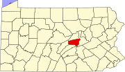
Snyder County is a county in the Commonwealth of Pennsylvania. As of the 2020 census, the population was 39,736. The county seat is Middleburg. Snyder County was formed in 1855 from parts of Union County.
Northumberland County is a county in the Commonwealth of Pennsylvania. It is part of Northeastern Pennsylvania. As of the 2020 census, the population was 91,647. Its county seat is Sunbury.
Clearfield is a borough and the county seat of Clearfield County, Pennsylvania, United States. As of the 2020 census the population was 5,962 people, making it the second most populous community in Clearfield County, behind DuBois. The borough is part of the DuBois, PA Micropolitan Statistical Area, as well as the larger State College-DuBois, PA Combined Statistical Area. The settled area surrounding the borough consists of the nearby census-designated places of Hyde and Plymptonville, which combined with Clearfield have a population of approximately 8,237 people.
Washington Township is a township in Lycoming County, Pennsylvania, United States. The population was 1,769 at the 2020 census. It is part of the Williamsport Metropolitan Statistical Area.
Mount Carmel is a borough in Northumberland County, located in the Coal Heritage Region of Central Pennsylvania's Susquehanna River Valley, United States. The population was 5,725 at the 2020 census. It is located 88 miles (141 km) northwest of Philadelphia and 71 miles (114 km) northeast of Harrisburg, in the Coal Region. It is completely encircled by Mount Carmel Township.
Shamokin is a city in Northumberland County, Pennsylvania, United States. Surrounded by Coal Township at the western edge of the Anthracite Coal Region in central Pennsylvania's Susquehanna River Valley, the city was named after a Saponi Indian village, Schahamokink. At the 2020 United States census, the population was 6,942.
Sunbury is a city and county seat of Northumberland County, Pennsylvania, United States. The principal city in the Sunbury, PA Micropolitan Statistical Area, it is also one of three principal cities in the Bloomsburg-Berwick-Sunbury, PA Combined Statistical Area.
Middleburg is a borough in Snyder County, Pennsylvania, United States. Located in Central Pennsylvania's Susquehanna River Valley, the borough's population was 1,325 at the 2020 census. It is the county seat of Snyder County. Middleburg is part of the Selinsgrove, PA Micropolitan Statistical Area, and is also part of the larger Bloomsburg-Berwick-Sunbury, PA Combined Statistical Area.
Monroe Township is a township in Snyder County, Pennsylvania, United States. The population was 4,145 at the 2020 census.
Selinsgrove is the largest borough in Snyder County, Pennsylvania, United States. The population is estimated to be 5,761 for the 2020 Census.
Shamokin may refer to the following:
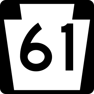
Pennsylvania Route 61 is an 81.8-mile-long (131.6 km) state highway in the U.S. state of Pennsylvania. The route is signed on a north–south direction, running from U.S. Route 222 Business in Reading northwest to US 11/US 15/PA 147 in Shamokin Dam. PA 61 heads north from Reading through Berks County to Hamburg, where it meets Interstate 78 (I-78)/US 22. The route continues into the Coal Region in Schuylkill County and heads through Schuylkill Haven, Pottsville, Frackville, and Ashland. PA 61 passes through the southern part of Columbia County, where it turns west in Centralia, before it heads into Northumberland County and runs west through Mount Carmel, Kulpmont, Shamokin, and Sunbury. The route crosses the Susquehanna River into Snyder County and soon reaches its northern terminus.
Shamokin was a multi-ethnic Native American trading village on the Susquehanna River, located partially within the limits of the modern cities of Sunbury and Shamokin Dam, Pennsylvania. It should not be confused with present-day Shamokin, Pennsylvania, located to the east. The village was the focus of missionary efforts, and then was the staging area for raids on English settlements in Pennsylvania during the French and Indian War. It was burned and abandoned by the Lenape in May, 1756. A few months later, Fort Augusta was constructed on the site of the village.
White Deer Hole Creek is a 20.5-mile (33.0 km) tributary of the West Branch Susquehanna River in Clinton, Lycoming and Union counties in the U.S. state of Pennsylvania. A part of the Chesapeake Bay drainage basin, the White Deer Hole Creek watershed drains parts of ten townships. The creek flows east in a valley of the Ridge-and-valley Appalachians, through sandstone, limestone, and shale from the Ordovician, Silurian, and Devonian periods.
The Great Island Path was a major Native American trail in the U.S. state of Pennsylvania that ran from the village of Shamokin along the right bank of the West Branch Susquehanna River north and then west to the Great Island.
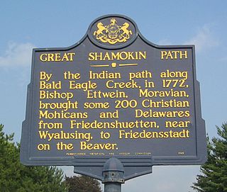
The Great Shamokin Path was a major Native American trail in the U.S. State of Pennsylvania that ran from the native village of Shamokin along the left bank of the West Branch Susquehanna River north and then west to the Great Island. There it left the river and continued further west to Chinklacamoose and finally Kittanning on the Allegheny River.
Shikellamy State Park is a 132-acre (53 ha) Pennsylvania state park located at the confluence of the West Branch Susquehanna River and Susquehanna River in Pennsylvania. The park is divided into two sections. The older part, on a bluff on the western bank of the Susquehanna River, is the 78-acre (32 ha) Shikellamy overlook in Union Township, Union County. The newer part is the 54-acre (22 ha) marina on the southern end of Packer Island in Upper Augusta Township, Northumberland County. Packer's Island lies between the city of Sunbury and the borough of Northumberland at the confluence of the two branches of the river.
Pennsylvania Route 147 is a north–south route that runs for 58.3 miles (93.8 km) along the east shore of the Susquehanna River in central Pennsylvania, United States. The southern terminus is at an interchange with U.S. Route 22 /US 322 in Reed Township. The northern terminus is at an interchange with Interstate 80 (I-80) and I-180 in Turbot Township.
The Central Susquehanna Valley Thruway (CSVT), also known as the Central Susquehanna Valley Transportation Project, is a partially-completed 10.84-mile (17.45 km) highway bypass along the U.S. Route 15 (US 15) corridor near Shamokin Dam, Pennsylvania. It has been designated as part of Corridor P-1 of the Appalachian Development Highway System by the Appalachian Regional Commission. When complete, it will carry US 15 and Pennsylvania Route 147 (PA 147) over varying stretches of its length. The project includes the construction of a new bridge over the West Branch Susquehanna River and 11.7 miles (18.8 km) of new roadway, including a short freeway connection to PA 61. The first phase of the project, connecting US 15 in Winfield with PA 147 near Montandon, opened in August 2022.
The Sunbury and Lewistown Railroad was a Class I Railroad connecting Lewistown, Pennsylvania with Sunbury, Pennsylvania. Completed in December 1871, the line was placed under an immediate lease by the Pennsylvania Railroad (PRR), upon its completion. Although retaining its own board of directors and track maintenance, all locomotive traffic was owned by the PRR. For over eighty years, the line operated between Sunbury and Lewistown, serving as a relief line for both the Philadelphia Main Line and Bald Eagle Valley Railroad through Williamsport, Pennsylvania. The line was noteworthy as a proving ground for new railroad technology in the United States, such as the "X"-shaped railroad crossing signs in 1917 and Pulse Code Cab Signaling technology in 1925. It is now a fallen flag railway, the name "Sunbury and Lewistown" having been phased out in 1901 when the line became part of the Pennsylvania Railroad's Sunbury Division.
This page is based on this Wikipedia article Text is available under the CC BY-SA 4.0 license; additional terms may apply. Images, videos and audio are available under their respective licenses.