
Southbury is a town in western New Haven County, Connecticut, United States. Southbury is north of Oxford and Newtown, and east of Brookfield. Its population was 19,879 at the 2020 census. The town is part of the Naugatuck Valley Planning Region.

Lake Buchanan was formed by the construction of Buchanan Dam by the Lower Colorado River Authority to provide a water supply for the region and to provide hydroelectric power. Buchanan Dam, a structure over 2 mi (3.2 km) in length, was completed in 1939. Lake Buchanan was the first of the Texas Highland Lakes to be formed, and with 22,333 acres of surface water, it is also the largest. The surface of the lake includes area in both Burnet and Llano Counties. The lake is west of the city of Burnet, Texas.

The Housatonic River is a river, approximately 149 miles (240 km) long, in western Massachusetts and western Connecticut in the United States. It flows south to southeast, and drains about 1,950 square miles (5,100 km2) of southwestern Connecticut into Long Island Sound.
The Salt River Project (SRP) encompasses two separate entities: the Salt River Project Agricultural Improvement and Power District, an agency of the state of Arizona that serves as an electrical utility for the Phoenix metropolitan area, and the Salt River Valley Water Users' Association, a utility cooperative that serves as the primary water provider for much of central Arizona. It is one of the primary public utility companies in Arizona.

Merrill Creek Reservoir, located in Harmony Township, New Jersey in central Warren County, New Jersey, is a 650-acre (260 ha) artificial lake designed to hold 15 billion gallons of water that is surrounded by 290 acres (120 ha) of protected woodland and fields. These lands are themselves part of 2,000 acres (8.1 km2) of open spaces.

Trinity Dam is an earthfill dam on the Trinity River located about 7 miles (11 km) northeast of Weaverville, California in the United States. The dam was completed in the early 1960s as part of the federal Central Valley Project to provide irrigation water to the arid San Joaquin Valley.

Trinity Lake, previously called Clair Engle Lake, is a reservoir on the Trinity River formed by the Trinity Dam and located in Trinity County, California, United States. The dam was built by the U.S. Bureau of Reclamation. The lake's capacity is 2,447,650 acre⋅ft (3,019.13 GL), making it one of the largest reservoirs in California. The lake's surface is at 2,370 ft (720 m) above MSL. Trinity Lake captures and stores water for the Central Valley Project, which provides the Central Valley with water for irrigation and produces hydroelectric power. This lake is known for its many small arms, glassy inlets, and good water-skiing conditions.
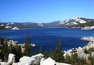
Courtright Reservoir is a reservoir in Fresno County, California. The reservoir is at an elevation of 8,170 feet in the Sierra National Forest, in the Sierra Nevada Mountain Range, bordering the John Muir Wilderness and the Dinkey Lakes Wilderness.

Lake Almanor is a large reservoir in northwestern Plumas County, northeastern California, United States. The reservoir has a capacity of 1,308,000 acre-feet (1.613×10⁹ m3) and a maximum depth of about 90 feet (27 meters). The surface area is 43.75 square miles (11,331.2 hectares). It is formed by Canyon Dam on the North Fork of the Feather River, as well as Benner and Last Chance Creeks, Hamilton Branch, and various natural springs.

Lucky Peak Dam is a rolled earth and gravel fill embankment dam in the western United States, located on the Boise River in southwestern Idaho. In Ada County east of Boise, it is directly downstream of Arrowrock Dam, a concrete arch dam completed in 1915. At the time of its construction in the early 1950s, Lucky Peak's primary purpose was flood control, with a secondary purpose of irrigation. The normal operating elevation of the full reservoir is 3,055 feet (931 m) above sea level, the empty reservoir's elevation is 2,824 feet (861 m).
The Lillinonah Trail is a 5.9-mile (9.5 km) Blue-Blazed hiking trail "system" in the lower Housatonic River valley in Fairfield County and, today, is entirely in Newtown. Most of the trail is in the upper block of Paugussett State Forest.

The Zoar Trail is a 6.5-mile (10.5 km) Blue-Blazed hiking trail "system" in the lower Housatonic River valley in Fairfield County, Connecticut and is entirely in the Sandy Hook section of Newtown in the lower block of Paugussett State Forest.
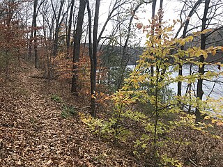
The Kettletown Trails are a 4.6-mile (7.4 km) Blue-Blazed hiking trail "system" in the lower Housatonic River valley in Fairfield County and are in the towns of Southbury and Oxford -- primarily in the Kettletown State Park and the Jackson Cove recreation area belonging to the town of Oxford.

Holter Dam is a hydroelectric straight gravity dam on the Missouri River about 45 miles (72 km) northeast of Helena, Montana, in the United States. The dam, which was built between 1908 and 1918, is 1,364 feet (416 m) long and 124 feet (38 m) high. The reservoir formed by the dam, Holter Lake is 25 miles (40 km) long and has a storage capacity of 243,000 acre-feet (300,000,000 m3) of water when full. The dam is a "run-of-the-river" dam because it can generate electricity without needing to store additional water supplies behind the dam.

The Shepaug River is a 26.0-mile-long (41.8 km) river in western Connecticut, in the United States.

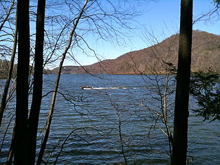
Lake Lillinonah is a manmade lake located in Fairfield, Litchfield and New Haven counties of Western Connecticut, approximately 60 miles (97 km) northeast of New York City. It is the second largest lake in Connecticut, smaller only than Candlewood Lake. The lake is bordered by six towns: Brookfield, Bridgewater, Newtown, New Milford, Roxbury, and Southbury. It was formed in 1955 by impoundment of the Housatonic River and the Shepaug River by the Shepaug Dam which was built by the Connecticut Light and Power Company. Some of the most expensive real estate in the Greater Danbury area is located on the shores of the lake, in the towns of Brookfield, Bridgewater and Newtown.
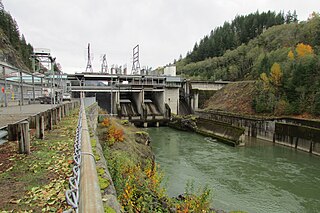
Cowlitz Falls Dam is a 70 megawatt hydroelectric dam in Lewis County, Washington. It was constructed in the early 1990s and completed in 1994. The dam is 140 feet (43 m) high and 700 feet (210 m) wide.

Abiquiu Dam is a dam on the Rio Chama, located about 60 miles (97 km) northwest of Santa Fe in Rio Arriba County, New Mexico, USA. Built and operated by the U.S. Army Corps of Engineers (USACE), the dam is an earth embankment structure 354 feet (108 m) high and 1,800 feet (550 m) long, containing 11.8 million cubic yards of fill. The dam forms Abiquiu Lake, one of the largest lakes in New Mexico, with a full storage capacity of 1,369,000 acre-feet (1,689,000 dam3) and 5,200 acres (2,100 ha) of water. To date, the reservoir has never filled to capacity, with a record high of 402,258 acre-feet (496,178 dam3), 29.4% of full pool, on June 22, 1987. The dam's primary purpose is flood control, in addition to irrigation and municipal water storage, and hydroelectric generation.
Northfield Mountain is a pumped-storage hydroelectric plant and reservoir located on and under the similarly named Northfield Mountain in Erving and Northfield, Massachusetts. It is currently owned by FirstLight Power Resources, which purchased the facility from Northeast Utilities in 2006.

Moore Dam is a major hydroelectric dam on the Upper Connecticut River between Grafton County, New Hampshire and Caledonia County, Vermont in the northeastern United States. The dam is located near Littleton, New Hampshire, and forms the 3,490-acre (1,410 ha) Moore Reservoir. The Moore Station is the largest conventional hydroelectric plant in New England, in terms of installed capacity and average power generation. The dam and reservoir also provide flood control, recreational boating and fishing.

