Ship John Shoal Light

Last updated
Ship John Shoal Light
Ship john shoal light.JPG
Ship John Shoal Light (USCG)
Ship John Shoal Light
LocationUpper Delaware Bay near the Bombay Hook NWR
Coordinates 39°18′19″N75°22′36″W / 39.30528°N 75.37667°W / 39.30528; -75.37667
Tower
Constructed1877
FoundationCast iron caisson
ConstructionCast iron with wood lining
Automated1973
Height14 m (46 ft)  OOjs UI icon edit-ltr-progressive.svg
ShapeOctagonal house with lantern on mansard roof
MarkingsBrown with black lantern
HeritageNational Register of Historic Places listed place  OOjs UI icon edit-ltr-progressive.svg
Fog signal Original: Bell, 3 every 45s
Current: Horn, 1 every 15s
Racon "O" (Oscar)
Light
First lit1877  OOjs UI icon edit-ltr-progressive.svg
Focal height50 feet (15 m)
LensFourth order Fresnel lens (original), VRB-25 (current)
RangeWhite 16 nautical miles (30 km; 18 mi)
Red 12 nautical miles (22 km; 14 mi)
Characteristic Flashing white 5s with red sector
Ship John Shoal Light Station
Area4.9 acres (2.0 ha)
ArchitectU.S. Lighthouse Board
Architectural styleSecond Empire
MPS Light Stations of the United States MPS
NRHP reference No. 06000630 [1]
NJRHP No. [2]
Added to NRHPJuly 19, 2006

The Ship John Shoal Light marks the north side of the ship channel in Delaware Bay on the east coast of the United States, near the Bombay Hook National Wildlife Refuge. Its cast iron superstructure was exhibited at the 1876 Centennial Exposition in Philadelphia, Pennsylvania. [3] [4]

History

Ship John Shoal took its name from an incident in 1797 in which the John, captained by Robert Folger, ran aground while on the way from Hamburg, Germany to Philadelphia. Passengers and cargo were unloaded safely, but the vessel was lost. (The figurehead is on exhibit in the Gibbon House Museum in Greenwich, New Jersey, the town to which the rescued passengers were taken.) [5]

Completion of the original Brandywine Shoal Light in 1850 led the Lighthouse Board to draw up plans to erect similar lights at Ship John Shoal and Cross Ledge. Both of these were intended to be of the then-new screw-pile design. During construction of the Cross Ledge Light in the winter of 1856, however, ice carried away the entire structure, prompting reconsideration of the suitability of this type of foundation. [4] In the 1870s caisson foundations became available, and in 1873 Congress appropriated funds toward the construction of a caisson light on the shoal. Wooden piles were driven and the caisson placed in 1874; however, insufficient time remained in the working season to complete the light, and a temporary structure was placed to allow display of a light from November of that year. [5]

The incomplete structure managed to withstand the winter ice, but in January the keepers abandoned their temporary refuge out of fear that it would be overturned. [5] They were able to return in March, but by then, the permanent superstructure had been diverted to the Southwest Ledge Light in Connecticut. An identical cast iron house was fabricated, but it was diverted to Philadelphia for display at the Centennial Exhibition, where it was even occupied by a keeper tending a working light in its lantern. [5] The house did not reach the caisson until the summer of 1877; in the meantime, a lightship was stationed alongside the unfinished structure. The base had also been surrounded with 2,000 tons of riprap to ward off ice damage. [5]

In 1907 additional riprap was dumped around the light, and about the same time a concrete platform was built on one of the two piles of rock in order to hold tanks for which there was no room in the light itself. [5] In 1973 the light was automated, and four years later the original Fresnel lens was removed and replaced by a solar powered beacon, whose solar panels stand on the platform where the tanks once rested. [6]

In June 2011, the General Services Administration made the Ship John Shoal Light (along with 11 others) available at no cost to public organizations willing to preserve them. [7] [8]

Related Research Articles

<span class="mw-page-title-main">Screw-pile lighthouse</span>

A screw-pile lighthouse is a lighthouse which stands on piles that are screwed into sandy or muddy sea or river bottoms. The first screw-pile lighthouse to begin construction was built by the blind Irish engineer Alexander Mitchell. Construction began in 1838 at the mouth of the Thames and was known as the Maplin Sands lighthouse, and first lit in 1841. However, though its construction began later, the Wyre Light in Fleetwood, Lancashire, was the first to be lit.

<span class="mw-page-title-main">Seven Foot Knoll Light</span> Lighthouse in Maryland, United States

The Seven Foot Knoll Light was built in 1855 and is the oldest screw-pile lighthouse in Maryland. It was located atop Seven Foot Knoll in the Chesapeake Bay until it was replaced by a modern navigational aid and relocated to Baltimore's Inner Harbor as a museum exhibit.

<span class="mw-page-title-main">Race Rock Light</span> Lighthouse

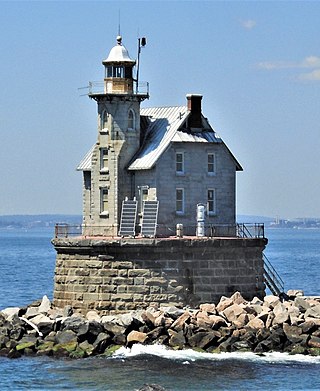
Race Rock Light is a lighthouse on Race Rock Reef, a dangerous set of rocks on Long Island Sound southwest of Fishers Island, New York and the site of many shipwrecks. It is currently owned and maintained by the New London Maritime Society as part of the National Historic Lighthouse Preservation Act program.

<span class="mw-page-title-main">Thomas Point Shoal Light</span> Lighthouse in Maryland, United States

The Thomas Point Shoal Light, also known as Thomas Point Shoal Light Station, is a historic lighthouse in the Chesapeake Bay on the east coast of the United States, and the most recognized lighthouse in Maryland. It is the only screw-pile lighthouse in the bay which stands at its original site. The current structure is a 1½ story hexagonal wooden cottage, equipped with a foghorn as well as the light.

<span class="mw-page-title-main">Texas Tower (lighthouse)</span>

A Texas Tower lighthouse is a structure which is similar to an off-shore oil platform. Seven of these structures were built in the 1960s off the shores of the United States. Automation started in the late 1970s, which led to the obsolescence of the housing built for the keepers which resulted in such a large structure. Three of the towers were dismantled over time due to deteriorating structural conditions among other problems, while another one was destroyed in a ship collision. The last Texas Tower was deactivated in 2016 having served for over half a century. Today only three of the former lights remain.

<span class="mw-page-title-main">Harbor of Refuge Light</span> Lighthouse in Delaware, United States

The Harbor of Refuge Light is a lighthouse built on the ocean end of the outer Delaware Breakwater at the mouth of the Delaware Bay, just off Cape Henlopen. It was built to function with the Delaware Breakwater East End Light in order to mark the National Harbor of Refuge.

<span class="mw-page-title-main">Orient Point Light</span> Lighthouse off Long Island, New York

Orient Point Light is a sparkplug lighthouse off Orient Point, New York in Plum Gut of Long Island Sound – the deep and narrow gap between Orient Point and Plum Island. It was built in 1899 and was automated in 1954. The lighthouse was listed on the National Register of Historic Places in 2007.

<span class="mw-page-title-main">Greens Ledge Light</span> Lighthouse in Connecticut, U.S. (1902)

Greens Ledge Lighthouse is a historic offshore lighthouse in the western Long Island Sound near Norwalk, Connecticut and Darien, Connecticut. It is one of 33 sparkplug lighthouses still in existence in the United States and remains an active aid to navigation. It sits in ten feet of water on the west end of Greens Ledge, a shallow underwater reef that runs a mile west of Sheffield Island and is roughly a mile south of the entrance to Five Mile River at Rowayton. Completed in 1902 by the Philadelphia Construction Company, the cast-iron structure is approximately 90 feet tall including roughly 15 feet of the submerged caisson. In 1933, more than 30,000 tons of rocks from the excavation of Radio City Music Hall were added to the riprap foundation. The light was added to the National Register of Historic Places as Greens Ledge Lighthouse on May 29, 1990.

<span class="mw-page-title-main">Southwest Ledge Light</span> Lighthouse

Southwest Ledge Light is an active lighthouse marking the main entrance channel to the harbor of New Haven, Connecticut. Completed in 1877, it was one of the first to be built on a cylindrical iron foundation, an innovation by Maj. George H. Elliot to address shifting ice that is regarded to be very important in lighthouse design. The lighthouse was listed on the National Register of Historic Places in 1990 as Southwest Ledge Lighthouse.

<span class="mw-page-title-main">Pungoteague Creek Light</span> Lighthouse in Virginia, United States

The Pungoteague Creek Light was a small screwpile lighthouse constructed in the Chesapeake Bay in 1854. Destroyed in 1856, it had the shortest recorded existence of any lighthouse on the Bay, and possibly the United States, at just 459 days.

<span class="mw-page-title-main">Sandy Point Shoal Light</span> Lighthouse in Maryland, United States

Sandy Point Shoal Light is a brick three story lighthouse on a caisson foundation that was erected in 1883. It lies about 0.6 mi (0.97 km) off Sandy Point, north of the Chesapeake Bay Bridge, from whose westbound span it is readily visible.

<span class="mw-page-title-main">Wolf Trap Light</span> Lighthouse in Virginia, United States

Wolf Trap Light is a caisson lighthouse in the Virginia portion of the Chesapeake Bay, about seven and a half miles northeast of New Point Comfort Light. It is listed on the National Register of Historic Places.

The National Historic Lighthouse Preservation Act of 2000 is American legislation creating a process for the transfer of federally owned lighthouses into private hands. It was created as an extension of the National Historic Preservation Act of 1966.

<span class="mw-page-title-main">Elbow of Cross Ledge Light</span> Lighthouse

The Elbow of Cross Ledge Light was a lighthouse on the north side of the ship channel in Delaware Bay in Cumberland County, New Jersey, on the east coast of the United States, west of Egg Island Point. It was destroyed by a ship collision in 1953 and replaced by a skeleton tower on the same foundation.

<span class="mw-page-title-main">Cross Ledge Light</span> Lighthouse

The Cross Ledge Light was a lighthouse on the north side of the ship channel in Delaware Bay off of Cumberland County, New Jersey on the East Coast of the United States, southwest of Egg Island Point. It was replaced by the Elbow of Cross Ledge Light and the Miah Maull Shoal Light in the early 1900s and razed by the United States Coast Guard in 1962.

<span class="mw-page-title-main">Brandywine Shoal Light</span> Lighthouse

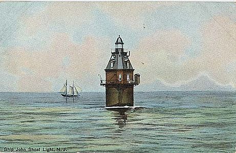
The Brandywine Shoal Light is a lighthouse on the north side of the ship channel in Delaware Bay on the east coast of the United States, west of Cape May, Cape May County, New Jersey, United States. It was the site of the first screw-pile lighthouse in the United States.

<span class="mw-page-title-main">Miah Maull Shoal Light</span> Lighthouse

The Miah Maull Shoal Light is a lighthouse on the north side of the ship channel in Delaware Bay, off of Cumberland County, New Jersey on the East Coast of the United States, southwest of the mouth of the Maurice River.

<span class="mw-page-title-main">Tarrytown Light</span> Lighthouse in New York, United States

Tarrytown Light, also known as Kingsland Point Light and Sleepy Hollow Light, is a sparkplug lighthouse on the east side of the Hudson River in Sleepy Hollow, New York, United States. It a conical steel structure erected in the 1880s. In 1979 it was listed on the National Register of Historic Places.

<span class="mw-page-title-main">Old Orchard Shoal Light</span> Lighthouse

Old Orchard Shoal Light was a sparkplug lighthouse in lower New York Bay marking a large shoal area. It was destroyed by Hurricane Sandy on October 29, 2012.

<span class="mw-page-title-main">National Harbor of Refuge and Delaware Breakwater Harbor Historic District</span> Historic district in Delaware, United States

The National Harbor of Refuge and Delaware Breakwater Historic District encompasses a series of seacoast breakwaters behind Cape Henlopen, Delaware, built between 1828 and 1898 to establish a shipping haven on a coastline that lacked safe harbors. The Harbor of Refuge is at the mouth of the Delaware Bay estuary where it opens into the Atlantic Ocean, at Lewes.

References

  1. "National Register Information System". National Register of Historic Places . National Park Service. March 13, 2009.
  2. "New Jersey and National Registers of Historic Places - Cumberland County" (PDF). New Jersey Department of Environmental Protection - Historic Preservation Office. April 1, 2010. p. 12. Archived from the original (PDF) on August 19, 2011. Retrieved October 13, 2010.
  3. Light List, Volume II, Atlantic Coast, Shrewsbury River, New Jersey to Little River, South Carolina (PDF). Light List. United States Coast Guard. 2009. p. 17.
  4. 1 2 "Historic Light Station Information and Photography: Delaware". United States Coast Guard Historian's Office. Archived from the original on 2017-05-01. N.B. The USCG site lists it in Delaware; it's actually in New Jersey.
  5. 1 2 3 4 5 6 "Ship John Shoal Lighthouse". lighthousefriends.com. Retrieved 2008-07-03.
  6. "Inventory of Historic Light Stations: New Jersey Lighthouses: Ship John Shoal Light" . Retrieved 2008-07-03.
  7. "For sale: Waterfront property; cozy, great views, plenty of light, needs TLC". CNN. Archived from the original on 15 July 2011. Retrieved 12 July 2011.
  8. Beatty, MaryAnne. "GSA Making 12 Historic Lighthouses Available at No Cost to Public Organizations Willing to Preserve Them". GSA Website. US General Services Administration. Archived from the original on 22 June 2011. Retrieved 12 July 2011.