
The Shivwits Band of Paiutes is a sovereign, federally recognized tribe located in southwestern Utah. The Shivwits Band is one of five Bands comprising the inter-Tribal government of the Paiute Indian Tribe of Utah.
The Shivwits Band of Paiutes is a sovereign, federally recognized tribe located in southwestern Utah. The Shivwits Band is one of five Bands comprising the inter-Tribal government of the Paiute Indian Tribe of Utah.
Shivwits comes from a Southern Paiute word, sipicimi. The word may be based on the prefix sibi-, meaning "east" or si-vints, meaning "people who live in the east." It is also spelled Shivwitz, Shi'-vwits, She-bits, Sübü'ts, and Sebit. The Shivwits Plateau in Arizona is named after the tribe. [1] Today the Shivwits Band of Paiute Indians of Utah identify as See’veets eng, meaning "Whitish Earth People". [2]
The Paiutes trace their origin story to the tale of Tabuts who was a wise wolf and older brother to Shinangwav, the mischievous coyote. Mankind was created as Tabuts decided to carve many different people out of sticks. When he was finished, he placed the people in a sack, so he could scatter them evenly throughout the whole earth so that all people would have a fair share of land to live upon. However, the sly Shinangwav had another idea. Legend tells that Shinangwav cut open the sack and the people fell out in small concentrated clusters all over the world. This uneven distribution and disruption brought among the people much contention and fighting between humans. As legend has it, the few remaining people left in the sack were blessed by Tabuts and placed in Earth's choicest land: those people were the Southern Paiutes. [3]
The Shivwits Paiutes settled in Utah around 1100 BC. Typically the Shivwits people are portrayed as hunter-gatherers who sought after berries, roots and pine nuts and hunted game such as rabbits and deer. However, excavations of two proto-historic features near the Santa Clara River provide evidence of Southern Paiute practice of garden cultivation (horticulture) such as wheat grains and maize cob and kernel fragments. [4] They were farmers living along the Santa Clara River and the Virgin River and cultivated crops of corn, squash, melons, gourds, sunflowers, and, after European contact, winter wheat. [5] They also practiced irrigation agriculture along the banks of the Virgin and Santa Clara river. [6]
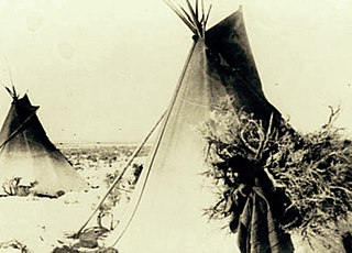
The people in the Shivwits Band of Paiutes camped together in family groupings. They had a nomadic mobile lifestyle and moved around frequently. [7] For shelter, many created cone-shaped wickiups to live in. Later, some used tepees. [8] In the spring and summer they would gather, plant, and hunt food in preparation for winter. After growing season was over in the fall they would gather together to celebrate marriages and have dances. (Other major celebrations include the pine nut harvest at the spring fish spawn.) In the winter they told stories of the Wolf and the Coyote, and recounted the history of their people. [6]
It is likely that the Shivwits Plateau was also once a source of ceramic pottery that contributed to a thriving ceramic trade system that linked regions around southern Nevada and northwestern Arizona. These Shivwits wares were composed of iron rich, dark brown/red ceramic materials, as well as crushed Moapa Gray Ware shards, all of which support the Shivwits production of these Native American ceramics. With near total consistency, these Shivwits wares were most commonly characterized by their style of being very large jars, large enough that it would take one person to transport just one jar. This ceramic trade, however, disappeared under unknown circumstances and only the historical evidence remains in support of its existence. [9]
The Domínguez–Escalante expedition of 1776 was most likely the Shivwits' first contact with Europeans. Fur trader Jedediah Smith created a route to California directly through Paiute territory. The 19th century brought non-Native trappers, traders, and settlers to the area. The newly introduced livestock had a negative effect on the area's delicate ecology. Utes and Navajos often captured Paiute women and children and sold them to European-Americans as slaves. [3]
Spurred by the era of rapid expansion of settlers in the mid 19th century in Southern Utah, white settlement of the land marked the end of the Native American sovereignty and traditional lifestyle. By 1858, these settlers, predominantly Mormons, permanently settled on Paiute lands, putting an end to the Shivwits' traditional lifestyle. [5] These settlers colonized many places that the Natives used for foraging, which resulted in many Natives facing problems with starvation. New diseases were also introduced to the Native Americans, whose epidemics ultimately killed 90 percent of some groups, drastically reducing their population. As a result, many Natives were pressed by the effects of poverty and vulnerability, and often, many women and children would turn to roles of servitude to the new settlers in order to support themselves. [10]
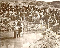
The settlement of Mormons also had unique assimilating consequences upon the Shivwits through the intensive proselytizing efforts of the Mormon settlers. C. R. Savage, travelling with Mormon missionaries, captured the mass baptisms of Shivwits on March 19, 1875 through photography, and his photo has since been famously used to represent the expansion of early white Mormon settlers and their positive and negative impact on Indian society. Though uncertain, most reports agree that at least 160 Shivwits were baptized by Mormon missionaries—men, women, and children up to 60 years old. Within Savage’s historic photograph, is pictured Chief Qui-Tuss, or “Burning Fire,” standing in the water, preparing to be baptized by Bishop Daniel McArthur. As per custom, the chief, who was around fifty years old, was the first to be baptized as an act of respect to the chief, and to also encourage other tribe members to follow his lead. [11]
In the late 1880’s, a rancher named Anthony W. Ivins began efforts to convince the federal government that the Shivwits Band of Southern Paiutes should be moved to an area along the Santa Clara river. [12] A few years later, the first Paiute reservation was established in 1891 on the Santa Clara River, west of St. George, Utah. It did not receive water rights so they were forced to abandon farming. [13] The reservation had a population of 194 that year. There were 154 Shivwits in 1906. [14] The Shivwits Band of Paiute Indians of Utah first received federal recognition on March 3, 1891 as the "Shebit tribe of Indians in Washington County, Utah." [5]
Although the Shivwits Reservation was established in 1891 on the Santa Clara River, it wasn’t formally recognized by the government until 1903. And although in 1916 President Woodrow Wilson issued an order to expand the reservation to 26,880 acres, the land was still too resource poor for the Shivwits to survive, so they were dependent on the federal government. In 1954, the US policy of Indian termination, which was created to encourage self-sufficiency among Native American Tribes and enforce assimilation into American society, had disastrous social and economic consequences on the Tribes. Their loss of federal recognition, and eligibility for federal support, meant that half of all tribal members died between 1954 and 1980, due to lack of basic health resources. With inadequate income to meet their needs, the Paiutes could also not afford to pay property taxes, and lost about 15,000 acres of former reservation lands. Like most Native American tribes during the termination era, the Shivwits began to suffer from diminishing pride in their cultural heritage. [3]
Following the era of Indian assimilation, the US Department of the Interior Office of Indian Affairs approved a new constitution on March 21, 1940 to alter the governmental workings of the Shivwits Band of Paiute Indians. This constitution was limited in the actual sovereignty and powers it granted the Paiute Indians, as most tribal constitutions issued by the US government during the Indian Termination period were. [15]
Along with other Utah Paiute tribes, the Shivwits' relationship with the federal government was terminated in the 1950s. [16] Unlike other Paiute groups, the Shivwits retained ownership of their lands after termination and leased them to ranchers, instead of selling them outright. Currently, the Shivwits Band have over 28,000 acres in Washington County. [17]
The Shivwits regained federal recognition through an act signed by President Jimmy Carter on 3 April 1980. [5] [16] This act, Public Law 96-227, served as the Paiute Indian Tribe of Utah Restoration Act, and was enacted to restore and confirm to the members of the Bands of Shivwits, Kanosh, Koosharem, and Indian Peaks, federal services and benefits, as well as extend services to the Cedar Band. [18]
The reservation is larger than it was originally, covering over 28,000 acres. In 2003, the Shivwits received water rights for 4,000 acre-feet (4,900,000 m3) annually, enabling the tribe to create new economic development projects. [13]
The Shivwits Band is governed by a Band Council, which coordinates with federal, state, and local governments on a government-to-government basis, working to protect and advance the sovereignty of the Shivwits Band as a federally recognized Indian Tribe through transparent and effective governance and effective economic development.
The Shivwits Band is one of five Bands comprising the inter-Tribal entity of the Paiute Indian Tribe of Utah. The Paiute Indian Tribe of Utah adopted an Indian-created constitution on June 11, 1991. It passed with a vote of 31 in favor and 14 opposed, and following the approval of Ronal Eden, director of the Office of Tribal Services, was officially adopted. [19]
As described by the constitution, the government of PITU is run by a council of six members, five of whom consist of one representative from each of the five constituent bands. These five members are chosen through popular vote in band elections, and become the respective band’s council member. By default, each band has a vice-council member, chosen by getting the second highest vote.
The sixth member is the tribal-chairperson. An election is subsequently held from among those just elected to be on the council, and are elected by all the members of the tribe eligible to vote. The council member chosen to be chairman vacates their position as council member, and their vice president becomes the new council representative of their respective band. A term for council members, vice-council members, chairman, and vice-chairman is four years.
This tribal council is the main governing body of PITU, and their powers include executive and legislative powers to promulgate and enforce laws. These powers include but aren’t limited to regulating laws, taxes, land and territory, so long as they don't infringe on US federal regulation, nor infringe on individual band rights which involve sovereign rights like autonomy and equality. [19]

The Band is headquartered in Ivins and the unincorporated community of Shivwits, located in Washington County, Utah. Their office is located at 6060 West 3650 North Ivins, UT 84738. The current band chairperson is Carmen Clark. [20]
Nine miles west of St. George on Highway 91, the Shivwits culture endures in a self-sustaining community surrounded by red cliffs. Their community includes forty homes, a health clinic, a community center, a gas station and a market. Economic development is an ongoing political challenge for the band, and in the dry desert basin water-lease agreements play an important role in economic survival. Future plans for the Shivwits reservation include building a gymnasium and cultural center. [10]
A significant concern for the Shivwits today is the rapid development of the surrounding land in Washington County, and its impact on the ancient history of the Paiute nations. Many artifacts such as petroglyphs and pottery are being disturbed by home development and rapid population growth in Southern Utah. [10]
Every year, the Paiute Restoration Gathering celebrates the reinstatement of federal recognition after the five bands of Utah Paiutes were terminated. Paiutes and their inner-tribal members all gather at an annual Pow-Wow, where they celebrate their tribal traditions by dancing and singing and performing ceremonies to help educate their youth about who they are and where they come from. [10]
The Shoshone or Shoshoni are a Native American tribe with four large cultural/linguistic divisions:

The Indigenous peoples of the Great Basin are Native Americans of the northern Great Basin, Snake River Plain, and upper Colorado River basin. The "Great Basin" is a cultural classification of indigenous peoples of the Americas and a cultural region located between the Rocky Mountains and the Sierra Nevada, in what is now Nevada, and parts of Oregon, California, Idaho, Wyoming, and Utah. The Great Basin region at the time of European contact was ~400,000 sq mi (1,000,000 km2). There is very little precipitation in the Great Basin area which affects the lifestyles and cultures of the inhabitants.
The Fort Hall Reservation is a Native American reservation of the federally recognized Shoshone-Bannock Tribes in the U.S. state of Idaho. This is one of five federally recognized tribes in the state. The reservation is located in southeastern Idaho on the Snake River Plain about 20 miles (32 km) north and west of Pocatello. It comprises 814.874 sq mi (2,110.51 km2) of land area in four counties: Bingham, Power, Bannock, and Caribou. To the east is the 60-mile-long (97 km) Portneuf Range; both Mount Putnam and South Putnam Mountain are located on the Fort Hall Reservation.
Blood quantum laws or Indian blood laws are laws in the United States that define Native American status by fractions of Native American ancestry. These laws were enacted by the federal government and state governments as a way to establish legally defined racial population groups. By contrast, many tribes do not include blood quantum as part of their own enrollment criteria.

The Southern Paiute people are a tribe of Native Americans who have lived in the Colorado River basin of southern Nevada, northern Arizona, and southern Utah. Bands of Southern Paiute live in scattered locations throughout this territory and have been granted federal recognition on several reservations. Southern Paiute's traditionally spoke Colorado River Numic, which is now a critically endangered language of the Numic branch of the Uto-Aztecan language family, and is mutually intelligible with Ute. The term Paiute comes from paa Ute meaning water Ute, and refers to their preference for living near water sources. Before European colonization they practiced springtime, floodplain farming with reservoirs and irrigation ditches for corn, squash, melons, gourds, sunflowers, beans and wheat.

Ute are the indigenous, or Native American people, of the Ute tribe and culture among the Indigenous peoples of the Great Basin. They had lived in sovereignty in the regions of present-day Utah and Colorado.

The Reno-Sparks Indian Colony in Nevada was established in the early 1900s by members of related tribes who lived near Reno for work; they became a federally recognized tribe in 1934 after forming a government under the Indian Reorganization Act.

The Kaibab Indian Reservation is the home of the Kaibab Band of Paiute Indians, a federally recognized tribe of Southern Paiutes. The Indian reservation is located in northern part of the U.S. state of Arizona. It covers a land area of 188.75 square miles (488.9 km2) in northeastern Mohave County and northwestern Coconino County adjacent to the southern Utah border. The Pipe Spring National Monument lies in the southwestern section of the reservation. The Thunder Mountain Pootseev Dark-sky preserve is colocated with the reservation.

The Duck Valley Indian Reservation was established in the 19th century for the federally recognized Shoshone-Paiute Tribe. It is isolated in the high desert of the western United States, and lies on the state line, the 42nd parallel, between Idaho and Nevada.

The Confederated Tribes of Warm Springs is a recognized Native American tribe made of three tribes who put together a confederation. They live on and govern the Warm Springs Indian Reservation in the U.S. state of Oregon.
The Timpanogos are a tribe of Native Americans who inhabited a large part of central Utah, in particular, the area from Utah Lake east to the Uinta Mountains and south into present-day Sanpete County.

The Paiute Indian Tribe of Utah is a federally recognized tribe of Southern Paiute and Ute Indians in southwestern Utah.

The Las Vegas Tribe of Paiute Indians of the Las Vegas Indian Colony is a federally recognized tribe of Southern Paiute Indians in Southern Nevada.
The Pahvant or Pahvants were a band of Ute people that lived in present-day Utah. Called the "Water People", they fished and hunted waterfowl. They were also farmers and hunter-gatherers. In the 18th century they were known to be friendly and attentive, but after a chief's father was killed by emigrating white settlers, a group of Pahvant Utes killed John Williams Gunnison and seven of his men during his exploration of the area. The bodies of water of their homeland were dried up after Mormons had diverted the water for irrigation. Having intermarried with the Paiutes, they were absorbed into the Paiute Indian Tribe of Utah and relocated to reservations.
The Santa Clara River is a 52-mile-long (84 km) river whose three forks join above Pine Valley in the Pine Valley Mountains in Washington County, Utah, United States. It flows west, then south, then briefly southeast before joining the Virgin River just south of downtown St. George. It is southern Utah's largest tributary to the Virgin River.
The Fort McDermitt Paiute and Shoshone Tribe is a federally recognized tribe of Northern Paiute and Western Shoshone peoples, whose reservation Fort McDermitt Paiute and Shoshone Tribes of the Fort McDermitt Indian Reservation spans the Nevada and Oregon border next to Idaho. The reservation has 16,354 acres (6,618 ha) in Nevada and 19,000 acres (7,700 ha) in Oregon.
Indigenous peoples have lived in the area now known as the state of Utah for thousands of years. Today they are divided into five main groups: Utes, Goshutes, Paiutes, Shoshone, and Navajo. Each occupies a different region within the state, many of which regions extend across borders into other states. In the 2010 census, there were a total of 32,927 American Indian and Alaska Natives living within the state, which totaled to 1.19% of the total population of Utah.
The Seuvarits Utes are a band of the Northern Ute tribe of Native Americans that traditionally inhabited the area surrounding present-day Moab, Utah, near the Grand River and the Green River. The Seuvarits were among the Ute bands that were involved in the Black Hawk War. The Seuvarits and other Ute bands were eventually relocated onto reservations by the United States government after their population severely declined after exposure to disease and war during the latter half of the 19th century.