Silver Lake, Oregon

Last updated

Silver Lake, Oregon
2017-07-12 Silver Lake 05.jpg
Silver Lake
USA Oregon location map.svg
Red pog.svg
Silver Lake
Usa edcp location map.svg
Red pog.svg
Silver Lake
Coordinates: 43°07′35″N121°02′58″W / 43.12639°N 121.04944°W / 43.12639; -121.04944
Country United States
State Oregon
County Lake
Area
[1]
  Total1.48 sq mi (3.83 km2)
  Land1.48 sq mi (3.83 km2)
  Water0.00 sq mi (0.00 km2)
Elevation
[2]
4,354 ft (1,327 m)
Population
 (2020) [3]
  Total159
  Density107.58/sq mi (41.52/km2)
Time zone UTC-8 (Pacific (PST))
  Summer (DST) UTC-7 (PDT)
ZIP code
97638
FIPS code 41-67600
GNIS feature ID2611778 [2]

Silver Lake is an unincorporated community and census-designated place in western Lake County, Oregon, United States, along Oregon Route 31. [4] As of the 2010 census, it had a population of 149. [5] Facilities include a gas station and a small store, [6] a post office, and a public school, North Lake School, serving grades K-12. [7]

Contents

History

The community of Silver Lake is located in the high desert of central Oregon. [8] The town is named for a lake of the same name that is 6 miles (10 km) east of town. On December 9, 1875, the post office was established. The post office location has moved at least twice, depending on where the house of the postmaster was at the time.

According to Oregon Geographic Names, "The most important happening in the history of the community was a fire that occurred on December 24, 1894, in which 43 people lost their lives in the burning of one building." A fire broke out at a Christmas Eve celebration inside the crowded second-floor hall above a store. Ed O'Farrell rode 100 miles (160 km) to Lakeview for medical help. [4] After receiving the message, Doctor Bernard Daly drove his buggy over bad winter roads for 24 hours to reach Silver Lake. Doctor Daly's efforts to reach and treat the victims earned statewide recognition. [9]

North Lake School in Silver Lake serves approximately 260 students from the towns of Silver Lake, Christmas Valley, and Fort Rock and consists of a single K-12 school building, which opened in 1991. [8]

Sparsely populated, but seeing an increase as Bend grows, the area is ideal for those interested in the outdoors; hunting, fishing, hiking, camping, skiing, and bird watching are favorite activities of local residents. Wildlife is abundant in the area, such as mule deer, pronghorn antelope, elk, coyotes, badgers, eagles, and hawks. [8]

Climate

This region experiences warm (but not hot) and dry summers, with no average monthly temperatures above 71.6 °F (22.0 °C). According to the Köppen Climate Classification system, Silver Lake has a warm-summer Mediterranean climate, abbreviated "Csb" on climate maps. [10]

Climate data for Silver Lake Ranger Station, Oregon (1991–2020 normals, extremes 1968–2020)
MonthJanFebMarAprMayJunJulAugSepOctNovDecYear
Record high °F (°C)65
(18)
74
(23)
76
(24)
85
(29)
92
(33)
100
(38)
105
(41)
102
(39)
99
(37)
90
(32)
78
(26)
62
(17)
105
(41)
Mean daily maximum °F (°C)40.4
(4.7)
44.5
(6.9)
50.5
(10.3)
56.1
(13.4)
65.8
(18.8)
74.0
(23.3)
85.4
(29.7)
84.3
(29.1)
76.1
(24.5)
62.5
(16.9)
47.6
(8.7)
37.7
(3.2)
60.4
(15.8)
Daily mean °F (°C)30.1
(−1.1)
33.2
(0.7)
37.3
(2.9)
41.9
(5.5)
50.0
(10.0)
56.7
(13.7)
65.4
(18.6)
63.5
(17.5)
55.8
(13.2)
45.7
(7.6)
35.4
(1.9)
28.2
(−2.1)
45.3
(7.4)
Mean daily minimum °F (°C)19.9
(−6.7)
22.0
(−5.6)
24.1
(−4.4)
27.7
(−2.4)
34.2
(1.2)
39.4
(4.1)
45.3
(7.4)
42.6
(5.9)
35.5
(1.9)
29.0
(−1.7)
23.2
(−4.9)
18.6
(−7.4)
30.1
(−1.1)
Record low °F (°C)−28
(−33)
−31
(−35)
−9
(−23)
3
(−16)
7
(−14)
11
(−12)
18
(−8)
22
(−6)
12
(−11)
−5
(−21)
−15
(−26)
−33
(−36)
−33
(−36)
Average precipitation inches (mm)0.96
(24)
0.89
(23)
1.17
(30)
0.80
(20)
1.48
(38)
0.85
(22)
0.48
(12)
0.38
(9.7)
0.46
(12)
0.60
(15)
0.82
(21)
1.43
(36)
10.32
(262)
Average precipitation days (≥ 0.01 in)8.18.57.78.47.75.73.82.53.45.76.99.077.4
Source: NOAA [11] [12]

Transportation

Silver Lake is located 79 miles (127 km) southeast of Bend and 103 miles (166 km) north of Lakeview on Oregon Route 31. Silver Lake Forest Service Strip is an airport 2 miles (3 km) southwest of Silver Lake.

Demographics

Historical population
CensusPop.Note
2020 159
U.S. Decennial Census [13] [3]

Related Research Articles

<span class="mw-page-title-main">Lake County, Oregon</span> County in Oregon, United States

Lake County is one of the 36 counties in the U.S. state of Oregon. As of the 2020 census, the population was 8,160. Its county seat is Lakeview. The county is named after the many lakes found within its boundaries, including Lake Abert, Summer Lake, Hart Lake, and Goose Lake.

<span class="mw-page-title-main">Terrebonne, Oregon</span> Unincorporated community in the state of Oregon, United States

Terrebonne is an unincorporated community and census-designated place (CDP) in Deschutes County, Oregon, United States. It is part of the Bend, Oregon Metropolitan Statistical Area. The population was 1,257 at the 2010 census.

<span class="mw-page-title-main">Lakeview, Oregon</span> Town in Oregon, United States

Lakeview is a town in Lake County, Oregon, United States. The population was 2,418 at the 2020 census. It is the county seat of Lake County. The city bills itself as the "Tallest Town in Oregon" because of its elevation, 4,757 feet (1,450 m) above sea level. Lakeview is situated in the Goose Lake Valley at the foot of the Warner Mountains and at the edge of Oregon's high desert country. Its economy is based on agriculture, lumber production, and government activities. In addition, tourism is an increasingly important part of the city's economy. Oregon's Outback Scenic Byway passes through Lakeview.

<span class="mw-page-title-main">Oakridge, Oregon</span> City in Oregon, United States

Oakridge is a city in Lane County, Oregon, United States. The population was 3,205 as of the 2010 census. It is located east of Westfir on Oregon Route 58, about 40 miles (64 km) east of Eugene and 150 miles (240 km) southeast of Portland. Surrounded by the Willamette National Forest and the Cascade Range, Oakridge is popular with outdoor enthusiasts for its hiking, mountain biking, wildflowers, fly fishing, birding, watersports, and the nearby Willamette Pass Resort.

<span class="mw-page-title-main">Sweet Home, Oregon</span> City in the United States

Sweet Home is a city in Linn County, Oregon, United States, with a population of 8,925 at the 2010 census. Built near the site of a prehistoric petrified forest, Sweet Home experienced substantial growth during the construction of the Green Peter and Foster dams in the 1940s. The town's main attraction nowadays is the Cascade mountains through Santiam Pass.

<span class="mw-page-title-main">Stayton, Oregon</span> City in Oregon, United States

Stayton is a city in Marion County, Oregon, United States, located 12 miles (19 km) southeast of the state capital, Salem, on Oregon Route 22. It is south of Sublimity and east of Aumsville. Located on the North Santiam River, Stayton is a regional agricultural and light manufacturing center. The population was 8,244 at the 2020 census. Established in 1872, it was incorporated in 1891. Stayton is part of the Salem Metropolitan Statistical Area.

<span class="mw-page-title-main">Alton, Utah</span> Town in the state of Utah, United States

Alton is a town in northwest Kane County, Utah, United States. The population was 119 at the 2010 census, a decrease from the 2000 figure of 134.

<span class="mw-page-title-main">Bly, Oregon</span> Unincorporated community in the state of Oregon, United States

Bly is an unincorporated community in Klamath County, Oregon, United States. By highway, it is about 50 miles (80 km) east of Klamath Falls. As of 2020, the population was 207.

<span class="mw-page-title-main">Mapleton, Oregon</span> Unincorporated community in the state of Oregon, United States

Mapleton is an unincorporated community in Lane County, Oregon, United States. It is located on Oregon Route 126 and the Siuslaw River, 45 miles (72 km) west of Eugene and 15 miles (24 km) east of Florence. It is also the western terminus of Oregon Route 36. As of the 2000 census, Mapleton had a total population of 918.

<span class="mw-page-title-main">Cascadia, Oregon</span> Unincorporated community in Oregon, US

Cascadia is an unincorporated community and census-designated place (CDP) that was established in 1892 on the South Santiam River, 14 miles (23 km) east of the current city of Sweet Home, in Linn County, Oregon, United States. As of the 2010 census it had a population of 147.

<span class="mw-page-title-main">Days Creek, Oregon</span> Unincorporated community in the state of Oregon, United States

Days Creek is an unincorporated community and census-designated place in Douglas County, Oregon, United States. At the 2010 census it had a population of 272.

<span class="mw-page-title-main">Plush, Oregon</span> Unincorporated community in the state of Oregon, United States

Plush is an unincorporated rural community and census-designated place in the Warner Valley of Lake County, in the U.S. state of Oregon. As of the 2010 census it had a population of 57. The community is in an arid, sparsely populated part of the state 39 miles (63 km) by road northeast of Lakeview. The valley surrounding Plush contains many marshes and shallow lakes, most of them intermittent.

<span class="mw-page-title-main">Crane, Oregon</span> Unincorporated community in the state of Oregon, United States

Crane is a census-designated place and unincorporated community in Harney County, Oregon, United States, northeast of Malheur Lake on Oregon Route 78. Its population was 116 at the 2020 census.

<span class="mw-page-title-main">Bernard Daly</span> American politician

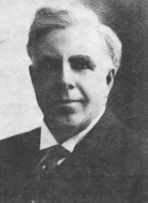
Bernard Daly was an American country doctor, businessman, banker, rancher, state representative, state senator, county judge, and regent of Oregon State Agricultural College. He also ran for United States Congress, and was his party's candidate for the United States Senate. Daly's educational trust fund has financed college educations for generations of Lake County, Oregon students, a legacy that continues to this day.

<span class="mw-page-title-main">Blodgett, Oregon</span> Unincorporated community in the state of Oregon, United States

Blodgett is a census-designated place (CDP) and unincorporated community in Benton County, Oregon, United States, where Oregon Route 180 meets U.S. Route 20 in the Central Oregon Coast Range 15 miles (24 km) west of Corvallis. It is near the confluence of the Tumtum and Marys rivers. As of the 2010 census, the community had a population of 58.

<span class="mw-page-title-main">Williams, Oregon</span> Unincorporated community in the state of Oregon, United States

Williams is an unincorporated community and census-designated place (CDP) in Josephine County, Oregon, United States. As of the 2010 census it had a population of 1,072.

<span class="mw-page-title-main">Valley Falls, Oregon</span> Unincorporated community in the state of Oregon, United States

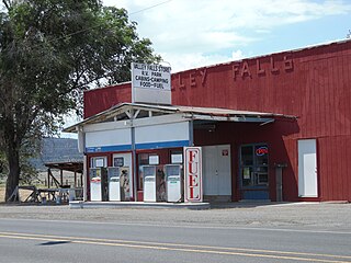
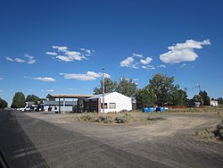
Valley Falls is a small unincorporated community in Lake County, Oregon, United States. The settled area is located at the junction of U.S. Route 395 and Oregon Route 31. The community is named for a small falls on the Chewaucan River just north of the occupied site. East of Valley Falls, the cliff face of Abert Rim overlooks the community.

Fairport is a former settlement in Modoc County, California. For 20 years, Fairport was a thriving resort community, and the supply and departure depot for the High Grade Mining District in the Warner Mountains.

Crescent is an unincorporated community in Klamath County, Oregon, United States. Crescent is along U.S. Route 97 about 47 miles (76 km) south-southwest of Bend. Crescent has a post office with ZIP code 97733.

<span class="mw-page-title-main">Lookingglass, Oregon</span> Unincorporated community in the state of Oregon, United States

Lookingglass is an unincorporated community and census-designated place in the Lookingglass Valley of Douglas County, Oregon, United States, about 9 miles (14 km) southwest of Roseburg. As of the 2010 census it had a population of 855. Lookingglass is considered a suburb of Roseburg.

References

  1. "ArcGIS REST Services Directory". United States Census Bureau. Retrieved October 12, 2022.
  2. 1 2 U.S. Geological Survey Geographic Names Information System: Silver Lake, Oregon
  3. 1 2 "Census Population API". United States Census Bureau. Retrieved October 12, 2022.
  4. 1 2
  5. "Total Population: 2010 Census DEC Summary File 1 (P1), Silver Lake CDP, Oregon". data.census.gov. U.S. Census Bureau. Retrieved August 19, 2020.
  6. Christmas Valley Chamber of Commerce 2006-2007 Tourist Guide
  7. "Home of the Cowboys". Archived from the original on March 2, 2001.
  8. 1 2 3 http://www.nlake.k12.or.us/district_information.htm%5B%5D
  9. Cooper, Forest E., Introducing Dr. Daly, Lake County Historical Society. Maverick Publications: Bend, Oregon, 1986
  10. Climate Summary for Silver Lake, Oregon
  11. "NOWData - NOAA Online Weather Data". National Oceanic and Atmospheric Administration. Retrieved December 10, 2023.
  12. "Summary of Monthly Normals 1991-2020". National Oceanic and Atmospheric Administration. Retrieved December 10, 2023.
  13. "Census of Population and Housing". Census.gov. Retrieved June 4, 2016.