
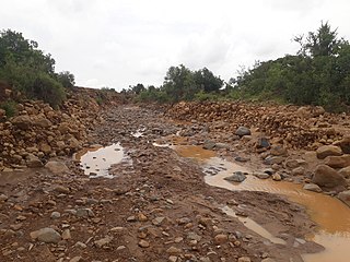
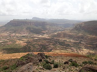
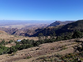
The soils of the Kilte Awula’ilo woreda (district) in Tigray, Ethiopia reflect its longstanding agricultural history, highly seasonal rainfall regime, relatively low temperatures, the presence of a wide depression at the foot of the Atsbi horst and steep slopes. Outstanding features in the soilscape are the wide ancient fluvial deposits, the soils of the granite batholith, cuestas and fertile lands behind tufa dams.

The soils of the Kola Tembien woreda (district) in Tigray (Ethiopia) reflect its longstanding agricultural history, highly seasonal rainfall regime, relatively high temperatures, overall dominance of sandstone and metamorphic lithology and steep slopes.

The Ab’aro is a river of the Nile basin. Rising in the mountains of Dogu’a Tembien in northern Ethiopia, it flows northwestward to empty into the Weri’i, which is a tributary of Tekezé River.

The Zeyi is a river of the Nile basin. Rising in the mountains of Dogu’a Tembien in northern Ethiopia, it flows southward to empty in Giba and Tekezé River.
The Qortem Zer’a is a river of the Nile basin. Rising in the mountains of Dogu’a Tembien in northern Ethiopia, it flows westward to empty finally in the Weri’i and Tekezé River.
The Agefet is a river of the Nile basin. Rising in the mountains of Gheralta in northern Ethiopia, it flows westward to empty finally in the Weri’i which itself discharges into Tekezé River.

The Ferrey is a river of the Nile basin. Rising in the mountains of Dogu’a Tembien in northern Ethiopia, it flows northward to empty finally in the Weri’i which in turn flows into Tekezé River.
The Kidane Mihret is a river of the Nile basin. Rising in the mountains of Dogu’a Tembien in northern Ethiopia, it flows northward to empty finally in the Weri’i and Tekezé River.

The Azef is a river in the Nile basin. Rising in the mountains of Dogu’a Tembien in northern Ethiopia, it flows northward to empty finally into the Weri’i which in turn discharges into Tekezé River.
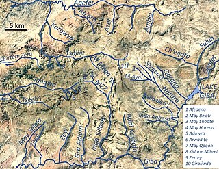
The Amblo is a river of the Nile basin. Rising in the mountains of Dogu’a Tembien in northern Ethiopia, it flows northward to empty finally in the Weri’i and Tekezé River.

The Tsech'i is a river of the Nile basin. Rising in the mountains of Dogu’a Tembien in northern Ethiopia, it flows westward to empty finally in Giba and Tekezé River.

The May Selelo is a river of the Nile basin. Rising in the mountains of Dogu’a Tembien in northern Ethiopia, it flows southward to empty in the Giba and Tekezé River.

The Zikuli, also called Gereb Awhi or Mennewe River, is a river of the Nile basin. Rising in the mountains of Dogu’a Tembien in northern Ethiopia, it flows southward to empty finally in the Giba and Tekezé River.
The Gra Adiam is a river of the Nile basin. Rising in the mountains of Dogu’a Tembien in northern Ethiopia, it flows southward where its name changes to Bitchoqo. It empties in the Giba and finally Tekezé River.

The May Sho’ate is a river of the Nile basin. Rising in the mountains of Dogu’a Tembien in northern Ethiopia, it flows southward to empty finally in Giba and Tekezé River.
The Addi Keshofo is a river of the Nile basin. Rising in the mountains of Dogu’a Tembien in Northern Ethiopia, it flows southwards to empty directly in the Giba and further in Tekezé River.

The Inda Anbesa is a river of the Nile basin. Rising in the mountains of Dogu’a Tembien in northern Ethiopia, it flows eastward to empty directly in the Giba and further in Tekezé River.

The Ruba Bich’i is a river of the Nile basin. Rising in the mountains of Dogu’a Tembien in northern Ethiopia, it flows southeastward to empty directly in the Giba and further in Tekezé River.
The Ch’eqofo is a river of the Nile basin. Rising in the mountains of Dogu’a Tembien in northern Ethiopia, it flows southwestward to empty finally in the Giba and Tekezé River.
The Tanqwa is a river of northern Ethiopia. Rising in the mountains of Dogu’a Tembien, it flows westward to Giba River which empties finally in the Tekezé River.
This page is based on this
Wikipedia article Text is available under the
CC BY-SA 4.0 license; additional terms may apply.
Images, videos and audio are available under their respective licenses.
