
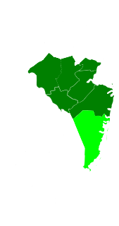
Somerset County is a county located in the central part of the U.S. state of New Jersey. As of the 2019 Census estimate, the county's population was 328,934, a 1.7% increase from the 2010 United States Census, making it the 13th most populous of the state's 21 counties. Somerset County is part of the New York Metropolitan Area. Its county seat is Somerville. The most populous place was Franklin Township, with 62,300 residents at the time of the 2010 Census, while Hillsborough Township, covered 55.00 square miles (142.4 km2), the largest total area of any municipality.
Montgomery Township is a township in southern Somerset County, New Jersey, United States. As of the 2010 United States Census, the township's population was 22,254, reflecting an increase of 4,773 (+27.3%) from the 17,481 counted in the 2000 Census, which had in turn increased by 7,869 (+81.9%) from the 9,612 counted in the 1990 Census.

Rocky Hill is a borough in Somerset County, New Jersey, United States, named for the Rocky Hill Ridge. Before roads were improved and people traveled by automobiles, it was known as the Devil's Featherbed because it was difficult to travel the rocky terrain by horse and wagon.
Central Jersey is the central region of the U.S. state of New Jersey. The designation of Central New Jersey with a distinct toponym is a colloquial one rather than an administrative one, with no official definition and with a sometimes contentious taxonomic existence. In December 2019, Governor of New Jersey Phil Murphy tweeted that the region exists.

New Jersey's Seventh Congressional District includes all of Hunterdon County, and parts of Essex, Morris, Somerset, Union, and Warren counties.

Route 92 was a 6.7-mile (10.8 km) proposed branch of the New Jersey Turnpike that would have run from west to east, beginning at U.S. Route 1 just north of Ridge Road in South Brunswick Township, east along Route 32, to Exit 8A in Monroe Township. Route 92 was also assigned in the 1953 renumbering and by the late 1950s it was named the Princeton–Hightstown Bypass, a freeway planned to connect the Somerset Freeway in Montgomery Township, with Route 33 in East Windsor Township. In 1987, the planned Route 92 was truncated to only run east from U.S. Route 1 near Kingston. New plans were announced in 1994, this time running to US 1 near Princeton. After public hearings found opposition was still strong, the planned route was truncated to a much shorter bypass of Hightstown only and numbered Route 133. Construction on the road, the first project awarded under New Jersey's modified Design-build program, began on September 20, 1996 and was opened November 30, 1999.
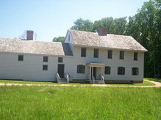
Rockingham is a historic house that was the home of John Berrien (1711–1772) and George Washington's final headquarters of the Revolutionary War. It is located at 84 Laurel Avenue, Franklin Township in Somerset County, New Jersey. The house was originally located on the hillside east of the Millstone River at Rocky Hill. It has been moved within southern Franklin Township several times, and is now closer to Kingston than to Rocky Hill. The residence is a featured part of the Millstone River Valley Scenic Byway. The oldest portion of the house was built as a two-room, two-story saltbox style house c. 1710; a kitchen and additional rooms were added on in the early 1760s, expanding with the Berrien family. The first reference to the house as "Rockingham" does not appear until a 1783 newspaper advertisement to sell the house, a name given most likely in honor of the Marquess of Rockingham.

The Six Mile Run Reservoir Site, part of the Delaware and Raritan Canal State Park, is located in Franklin Township, Somerset County, New Jersey, United States. It is adjacent to the Delaware and Raritan Canal. It covers 3,037 acres (12.29 km2). The reservoir plan was to flood the Six Mile Run watershed. The Six Mile Run is a tributary of the Millstone River that, with its tributaries, drains a large area in central Franklin Township, Somerset County, New Jersey and western portions of North Brunswick and South Brunswick Townships in Middlesex County, New Jersey. It derives its name, along with other streams, from the distance early surveyors estimated it was from the point where the historic King's Highway left the Raritan River at New Brunswick to the point the roadway crossed the stream. The estimates were not very accurate but the stream names have remained in use ever since.

The Blackwells Mills Canal House is located at Blackwells Mills Road and Canal Road in Franklin Township, Somerset County, New Jersey, United States, on the Delaware and Raritan Canal. Across the canal is Blackwells Mills, New Jersey.

Montgomery High School is a four-year comprehensive public high school located in the Skillman area of Montgomery Township, in Somerset County, New Jersey, United States, serving students in ninth through twelfth grades as the lone secondary school of the Montgomery Township School District. The school has been accredited by the Middle States Association of Colleges and Schools Commission on Secondary Schools since 1976.

Skillman is an unincorporated community and census-designated place (CDP) located within Montgomery Township, in Somerset County, New Jersey, United States. As of the 2010 United States Census, the CDP's population was 242.
The Mercer Oak was a large white oak tree that stood in Princeton Battlefield State Park in Princeton, New Jersey. The tree was about 300 years old when it was torn by strong winds in March 2000. It was the emblem of Princeton Township and appeared on the seal of the township. The tree is also the key element of the seal of Mercer County, New Jersey.
The Western precinct was one of three components of Somerset County, New Jersey, United States, that was created circa 1745 and existed until 1798.
The North Princeton Developmental Center, formerly known as the New Jersey State Village for Epileptics, was a medical facility within Montgomery Township, Somerset County, New Jersey. The facility was home to a variety of mental health institutions throughout the years. In 2011, the former self-sustaining mental health village was slated for demolition to make space for a proposed county park. Demolition was completed in 2012 with plans to begin construction of the conceptual park in 2013. The facility garnered much notoriety over the past decades due to its "ghost town" appearance and mention in the popular book and periodical, "Weird N.J." Until its demolition, the former hospital was a popular place for "urban explorers" to explore, despite the buildings being unsafe (partially due to asbestos and lead paint contamination. Urban explorers were often met with resistance from law enforcement, as the site was prone to criminal activity, ranging from graffiti to arson. Prior to the demolition of the site, state and local governments have both made reasonable attempts to keep trespassers out, for example by sealing the entrances and windows of the property, though these methods proved to be relatively ineffective.

Van Vorst Park is an upper income neighborhood in the Historic Downtown of Jersey City, Hudson County, New Jersey, United States, centered on a park sharing the same name. The neighborhood is located west of Paulus Hook and Marin Boulevard, north of Grand Street, east of the Turnpike Extension, and south of The Village and Christopher Columbus Drive. Much of it is included in the Van Vorst Park Historical District.
Bergen-Lafayette is a section of Jersey City, New Jersey.

The Sourlands is a region in the US state of New Jersey that includes portions of Hunterdon County, Mercer County and Somerset County. It is centered on Sourland Mountain and comprises parts of Lambertville, East Amwell, West Amwell, Hillsborough, Hopewell Boro, Hopewell Township, Montgomery. The region is flanked by the Hopewell Fault to the south and Amwell Valley to the north that runs from Mount Airy to an area just west of Flagtown and a diabase formation running from Lambertville to Mount Airy. The Sourland also include a hilly area towards the southwest called Pleasant Valley, with a number of farms. Although much of the Sourlands is not conducive to farming, Pleasant Valley and the slopes on the surrounding ridges have a number of farms. The slopes of the ridge to the north are also home to Unionville Vineyard.

Belle Mead station is a train station along the CSX Trenton Subdivision and former New Jersey Transit West Trenton Line in the Belle Mead section of Montgomery Township, in Somerset County, New Jersey, United States.

New Jersey's 16th Legislative District is one of 40 in the New Jersey Legislature. As of the 2011 apportionment, the district includes the Hunterdon County municipalities of Delaware Township, Flemington Borough, Raritan Township, Readington Township and Stockton Borough; the consolidated Mercer County municipality of Princeton; the Middlesex County municipality of South Brunswick Township; and the Somerset County municipalities of Branchburg Township, Hillsborough Township, Manville Borough, Millstone Borough, Montgomery Township, Rocky Hill Borough and Somerville Borough.
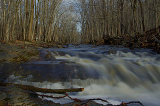
Zion is an unincorporated community along the border of Hillsborough Township and Montgomery Township in Somerset County, New Jersey, United States. It is located on Rock Brook, approximately 3 mi (4.8 km) north of Hopewell.
