Slippery Rock Brook

Last updated
Slippery Rock Brook
River
SlipperyRockBrookColor.jpg
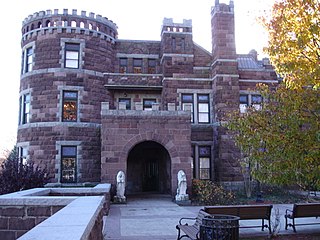
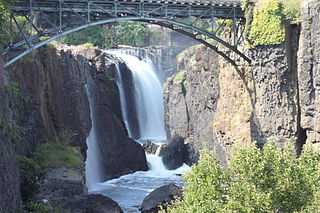
Slippery Rock Brook viewed from under Mountain Ave in Woodland Park
Country United States
State New Jersey
County Passaic
Source
 - location Woodland Park, Passaic County , New Jersey , United States
 - elevation 379 ft (116 m)
 - coordinates 40°53′23.34″N74°11′14.39″W / 40.8898167°N 74.1873306°W / 40.8898167; -74.1873306
Mouth Passaic River
 - location Paterson, Passaic County , New Jersey , United States
 - elevation 118 ft (36 m)
 - coordinates 40°54′42.8″N74°11′22.62″W / 40.911889°N 74.1896167°W / 40.911889; -74.1896167 Coordinates: 40°54′42.8″N74°11′22.62″W / 40.911889°N 74.1896167°W / 40.911889; -74.1896167
Length 2 mi (3 km)
PassaicRiverNorthBend.png
Major Tributaries of the North Bend of the Passaic River

Slippery Rock Brook is a tributary of the Passaic River in Passaic County, New Jersey in the United States.

Tributary stream or river that flows into a main stem river or lake

A tributary or affluent is a stream or river that flows into a larger stream or main stem river or a lake. A tributary does not flow directly into a sea or ocean. Tributaries and the main stem river drain the surrounding drainage basin of its surface water and groundwater, leading the water out into an ocean.

Passaic River river in New Jersey, United States

The Passaic River is a river, approximately 80 mi (129 km) long, in northern New Jersey in the United States. The river in its upper course flows in a highly circuitous route, meandering through the swamp lowlands between the ridge hills of rural and suburban northern New Jersey, called the Great Swamp, draining much of the northern portion of the state through its tributaries. In its lower portion, it flows through the most urbanized and industrialized areas of the state, including along downtown Newark. The lower river suffered from severe pollution and industrial abandonment in the 20th century. In April 2014, the U.S. Environmental Protection Agency announced a $1.7 billion plan to remove 4.3 million cubic yards of toxic mud from the bottom of lower eight miles of the river. It is considered one of the most polluted stretches of water in the nation and the project one of the largest clean-ups ever undertaken.

Passaic County, New Jersey county in New Jersey, United States

Passaic County is a county in the U.S. state of New Jersey that is part of the New York metropolitan area.

Contents

Slippery Rock Brook flows north as it drains part of the western flank of First Watchung Mountain. Traveling south from its confluence with the Passaic River, it passes through the city of Paterson and the borough of Woodland Park.

Watchung Mountains

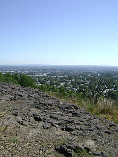
The Watchung Mountains are a group of three long low ridges of volcanic origin, between 400 and 500 feet high, lying parallel to each other in northern New Jersey in the United States. The Watchung Mountains are known for their numerous scenic vistas overlooking New York City, Newark and New Jersey skylines, as well as their isolated ecosystems containing rare plants, endangered wildlife, rich minerals, and globally imperiled trap rock glade communities. The ridges traditionally contained the westward spread of urbanization, forming a significant geologic barrier beyond the piedmont west of the Hudson River; the town of Newark, for example, once included lands from the Hudson to the base of the mountains. Later treaties moved the boundary to the top of the mountain, to include the springs. The Watchungs are basalt uplifts, geologically similar to the Palisades along the Hudson river. In many places, however, the mountains have become sinuous islands of natural landscape within the suburban sprawl covering much of contemporary northeastern New Jersey. Parks, preserves, and numerous historical sites dot the valleys and slopes of the mountains, providing recreational and cultural activities to one of the most densely populated regions of the nation.

Paterson, New Jersey City in New Jersey, United States

Paterson is the largest city in and the county seat of Passaic County, New Jersey, United States. As of the 2010 United States Census, its population was 146,199, making it New Jersey's third-most-populous city. Paterson has the second-highest density of any U.S. city with over 100,000 people, behind only New York City. For 2017, the Census Bureau's Population Estimates Program calculated a population of 148,678, an increase of 1.7% from the 2010 enumeration, making the city the 174th-most-populous in the nation.

Woodland Park, New Jersey Borough in New Jersey, United States

Woodland Park is a borough in Passaic County, New Jersey, United States. As of the 2010 United States Census, the borough's population was 11,819, reflecting an increase of 832 (+7.6%) from the 10,987 counted in the 2000 Census, which had in turn increased by 5 (+0.0%) from the 10,982 counted in the 1990 Census.

Course

Slippery Rock Brook arises south of Weasel Drift Road in Rifle Camp Park, in Woodland Park and travels north into Garret Mountain Reservation, forming the elongated Barbour Pond, a 0.3-mile (0.48 km) by 0.05-mile (0.080 km) natural lake. Turning west, the brook travels a short distance before forming the New Street Reservoir and Highland Lake, both man-made ponds.

Garret Mountain Reservation

Garret Mountain Reservation is a 568-acre (230 ha) park located primarily in Woodland Park in southern Passaic County, New Jersey, United States and one of several National Natural Landmarks in New Jersey.

At Highland Lake the brook turns north again, flowing under Interstate 80 as it enters Paterson. The brook takes on an urban appearance as it winds its last half mile to the Passaic River with its mouth in Pennington Park. The confluence with the Passaic occurs almost directly opposite the mouth of Molly Ann Brook, with Slippery Rock Brook's mouth approximately 300 feet (91 m) upstream.

Interstate 80 (I-80) is a major Interstate Highway in the United States, running from the New York City Metropolitan Area westward to San Francisco, California. The New Jersey Department of Transportation also identifies I-80 as the Christopher Columbus Highway. I-80 in New Jersey runs 68.54 miles (110.30 km) from the Delaware Water Gap Toll Bridge over the Delaware River at the Delaware Water Gap to its eastern terminus at I-95 in Teaneck, Bergen County. I-95 continues from the end of I-80 to the George Washington Bridge for access to New York City; access is also provided via the I-280 spur towards the Holland Tunnel and US 46 to Route 3, or I-95, towards the Lincoln Tunnel. Throughout New Jersey, I-80 runs parallel to US 46. The highway heads through rural areas of Warren and Sussex counties before heading into more suburban surroundings in Morris County. As the road continues into Passaic and Bergen counties, it heads into more urban areas.

Molly Ann Brook river in the United States of America

Molly Ann Brook is a tributary of the Passaic River which flows south between the northern ranges of First Watchung Mountain and Second Watchung Mountain in Passaic County and Bergen County, New Jersey. Traveling north from its confluence with the Passaic River, Molly Ann Brook passes through the city of Paterson and the boroughs of Haledon, Prospect Park, North Haledon and Franklin Lakes.

Ecology

The majority of Slippery Rock Brook’s riparian corridor has been overrun by urbanization, but a significant section remains intact through Garret Mountain Reservation. South of Barbour Pond, the brook passes through a ravine shaded by a stand of yellow birch and witch-hazel. Rhododendrons and trout lily are known to line the banks along this section of the brook, adding vibrant colors to the riparian environment during the flowering season in May. [1]

Riparian zone interface between land and a river or stream

A riparian zone or riparian area is the interface between land and a river or stream. Riparian is also the proper nomenclature for one of the fifteen terrestrial biomes of the Earth. Plant habitats and communities along the river margins and banks are called riparian vegetation, characterized by hydrophilic plants. Riparian zones are important in ecology, environmental resource management, and civil engineering because of their role in soil conservation, their habitat biodiversity, and the influence they have on fauna and aquatic ecosystems, including grasslands, woodlands, wetlands, or even non-vegetative areas. In some regions the terms riparian woodland, riparian forest, riparian buffer zone,riparian corridor and riparian strip are used to characterize a riparian zone. The word riparian is derived from Latin ripa, meaning river bank.

<i>Betula alleghaniensis</i> species of plant

Betula alleghaniensis, the yellow birch or golden birch, is a large and important lumber species of birch native to North-eastern North America. Its vernacular names refer to the color of the tree's bark. The name Betula lutea was used expansively for this tree but has now been replaced.

<i>Hamamelis virginiana</i> species of plant

Hamamelis virginiana, known as common or American witch-hazel, is a species of witch-hazel native to eastern North America, from Nova Scotia west to Minnesota, and south to central Florida to eastern Texas.

See also

Related Research Articles

Great Falls (Passaic River) waterfalls on the Passaic River

The Great Falls of the Passaic River is a prominent waterfall, 77 feet (23 m) high, on the Passaic River in the city of Paterson in Passaic County, New Jersey, United States. The falls and surrounding area are protected as part of the Paterson Great Falls National Historical Park, administered by the National Park Service. The Congress authorized its establishment in 2009.

Lake Passaic

Lake Passaic was a prehistoric proglacial lake that existed in northern New Jersey in the United States at the end of the last ice age approximately 19,000-14,000 years ago. The lake was formed of waters released by the retreating Wisconsin Glacier, which had pushed large quantities of earth and rock ahead of its advance, blocking the previous natural drainage of the ancestral Passaic River through a gap in the central Watchung Mountains. The lake persisted for several thousand years as melting ice and eroding moraine dams slowly drained the former lake basin. The effect of the lake’s creation permanently altered the course of the Passaic River, forcing it to take a circuitous route through the northern Watchung Mountains before spilling out into the lower piedmont.

Goffle Brook river in the United States of America

Goffle Brook is a tributary of the Passaic River which flows south through a section of Passaic County and Bergen County in New Jersey and drains the eastern side of the First Watchung Mountain. Heading up the brook from the confluence with the Passaic River, one encounters the borough of Hawthorne, the village of Ridgewood, the borough of Midland Park, and the township of Wyckoff.

Peckman River river in the United States of America

The Peckman River is a tributary of the Passaic River in Essex and Passaic Counties, New Jersey in the United States.

Loantaka Brook is a tributary of the Passaic River in New Jersey in the United States.

Downtown Paterson

Downtown Paterson is the main commercial district of Paterson, Passaic County, New Jersey, United States. The area is the oldest part of the city, along the banks of the Passaic River and its Great Falls. It is roughly bounded by Interstate 80, Garret Mountain Reservation, Route 19, Oliver Street, and Spruce Street on the south; the Passaic River, West Broadway, Cliff Street, North 3rd Street, Haledon Avenue, and the borough of Prospect Park on the west; and the Passaic River also to the north.

The Old Great Falls Historic District is an area of Paterson, New Jersey between South Paterson and Hillcrest, Paterson. The area is a thin strip of neighborhoods and parklands around the Passaic River and Garret Mountain. This section of Paterson has two National Natural Landmarks, Garret Mountain and Great Falls on the Passaic. It is the location of the highest point in Paterson. It is home to Lambert Castle and Alexander Hamilton's Society for the Establishment of Useful Manufactures (S.U.M.), which used the force of Great Falls to power the mills along the Passaic in the Dublin section. The neighborhood is also home to part of Garret Mountain Reservation and Overlook Park around the Grand Street Reservoir. The neighborhood is bounded by the border with Hillcrest by the Passaic River, by the Woodland Park border, the South Paterson border along Valley Road and Route 19. It is separated from Downtown Paterson to the north by Route 19, Oliver Street and Spruce Street.

Middlesex Fells Reservation Parkways

The Middlesex Fells Reservation Parkways are the roadways within and bordering on the Middlesex Fells Reservation, a state park in the northern suburbs of Boston, Massachusetts. The park includes portions of the towns of Malden, Medford, Melrose, Stoneham, and Winchester. The roads inside the park and around its perimeter have been listed on the National Register of Historic Places. Other portions of some of the roads are covered by more than one listing in the national register; see Fellsway Connector Parkways and Middlesex Fells Reservoirs Historic District.

The Lenape Trail is a trail connecting Newark, New Jersey with Roseland, New Jersey. It was established in 1982. It is the fifth longest trail in the state behind the Delaware and Raritan Canal Trail, the Appalachian Trail, the completed section of the Highlands Trail in the state and the Batona Trail. The Lenape trail traverses Newark and its suburbs, as well as the Watchung Mountains and Passaic Meadows. Because of the steepness of the Watchung Mountains and the flood-prone nature of the Passaic Meadows, the former basin of Glacial Lake Passaic, these areas have remained much less developed than the rest of the northeastern part of the state. This trail therefore offers hikers an opportunity to see cultural and historical sites of an urban trail, as well as large natural and undeveloped areas. The trail's proximity to New York City and the various ridges it traverses, including Forest Hill, Orange Mountain, and Second Watchung Mountain, offer many views of the skyline. The Lenape Trail forms a segment of the Liberty-Water Gap Trail and incorporates the West Essex Trail, the Lenape Trail's only rail-to-trail section. The Lenape Trail also connects with Morris County's Patriots Path trail system on its western terminus.

Goffle Brook Park

Goffle Brook Park is a public, county park spanning much of the length of Goffle Brook through the borough of Hawthorne in Passaic County, New Jersey, United States. Since its designation and construction between 1930 and 1932, the park has served to protect the waters of Goffle Brook while at the same time providing recreational opportunities to the residents of Passaic County and nearby Bergen County. Goffle Brook Park has been included in the National Register of Historic Places since 2002.

Goffle Hill mountain in United States of America

Goffle Hill, also referred to as Goffle Mountain and historically known as Totoway Mountain and Wagaraw Mountain, is a range of the trap rock Watchung Mountains on the western edge of the Newark Basin in northern New Jersey. The hill straddles part of the border of Bergen County and Passaic County, underlying a mostly suburban setting. While hosting patches of woodlands, perched wetlands, and traprock glades, the hill is largely unprotected from development. Extensive quarrying for trap rock has obliterated large tracts of the hill in North Haledon, and Prospect Park. Conservation efforts seeking to preserve undeveloped land, such as the local Save the Woods initiative (2007–present), are ongoing.

Kings Pond Park

Kings Pond Park, including the associated Gypsy Pond Park, is a public, municipal park spanning close to the entire length of Goffle Brook through the village of Ridgewood in Bergen County, New Jersey. It is the second largest wildscape in the village of Ridgewood and one of the larger wooded areas along the lower Bergen-Passaic border.

Lambert Castle

Lambert Castle, originally called Belle Vista, is located within the Garret Mountain Reservation in Paterson, Passaic County, New Jersey, United States. The building was built in 1892 and was added to the National Register of Historic Places on June 3, 1976.

Rifle Camp Park

Rifle Camp Park is a 225-acre (0.9 km2) county park of Passaic County, New Jersey. It is located mostly within Woodland Park, but its eastern edge extends into Clifton as well. The park includes hiking trails, an observatory, nature center, fitness trail, amphitheater, a bird watching blind, and an overnight camping facility for local scout organizations.

References

  1. Glenn, Steven. FIELD TRIP REPORTS - Garret Mountain Reservation. The Journal of the Torrey Botanical Society 135(1):149-153. Jan/Feb 2008. Available via BNET