Related Research Articles

The San Juan Islands are an archipelago in the Pacific Northwest of the United States between the U.S. state of Washington and Vancouver Island, British Columbia, Canada. The San Juan Islands are part of Washington state, and form the core of San Juan County.

Dungeness Spit is a sand spit jutting out approximately 5 miles (8 km) from the northern edge of the Olympic Peninsula in northeastern Clallam County, Washington into the Strait of Juan de Fuca. It is the longest natural sand spit in the United States. The spit is growing in length by about 15 feet (4.6 m) per year. The body of water it encloses is called Dungeness Bay.
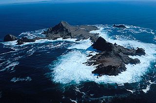
The Farallon Islands, or Farallones, are a group of islands and sea stacks in the Gulf of the Farallones, off the coast of San Francisco, California, United States. The islands are also sometimes referred to by mariners as the Devil's Teeth Islands, in reference to the many treacherous underwater shoals in their vicinity. The islands lie 30 miles (48 km) outside the Golden Gate and 20 miles (32 km) south of Point Reyes, and are visible from the mainland on clear days. The islands are part of the City and County of San Francisco. The only inhabited portion of the islands is on Southeast Farallon Island (SEFI), where researchers from Point Blue Conservation Science and the U.S. Fish and Wildlife Service stay. The islands are closed to the public.

Fastnet Lighthouse is a 54m high lighthouse situated on the remote Fastnet Rock in the Atlantic Ocean. It is the most southerly point of Ireland and lies 6.5 kilometres (4.0 mi) southwest of Cape Clear Island and 13 kilometres (8.1 mi) from County Cork on the Irish mainland. The current lighthouse is the second to be built on the rock and is the tallest in Ireland.

Point Wilson is at the end of the Quimper Peninsula, a northeast extension of the Olympic Peninsula and the northeasternmost point of Jefferson County, Washington, United States, approximately two miles north of the Port Townsend business district.
Skerryvore is a remote island that lies off the west coast of Scotland, 11 nautical miles southwest of Tiree. Skerryvore Lighthouse is located on these rocks, built with some difficulty between 1838 and 1844 by Alan Stevenson.
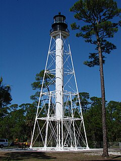
The Cape San Blas Light is a lighthouse in the state of Florida in the United States. There were four built between 1849 and 1885. It was located at Cape San Blas in the northwestern part of the state. Due to beach erosion and weather damage over the decades, it was moved in 2014 to Port St. Joe. The lighthouse was listed on the National Register of Historic Places in 2015.
Cape Flattery is the northwesternmost point of the contiguous United States. It is in Clallam County, Washington on the Olympic Peninsula, where the Strait of Juan de Fuca joins the Pacific Ocean. It is also part of the Makah Reservation, and is the northern boundary of the Olympic Coast National Marine Sanctuary. Cape Flattery can be reached from a short hike, most of which is boardwalked. The westernmost point in the contiguous United States is at Cape Alava, south of Cape Flattery in Olympic National Park. However, the westernmost tip of Cape Flattery is almost exactly as far west as Cape Alava, the difference being approximately 5 seconds of longitude, about 360 feet (110 m), at high tide and somewhat more at low tide.

The Montauk Point Light, or Montauk Point Lighthouse, is a lighthouse located adjacent to Montauk Point State Park, at the easternmost point of Long Island, in the hamlet of Montauk in the Town of East Hampton in Suffolk County, New York. The lighthouse was the first to be built within the state of New York, and was the first public works project of the new United States. It is the fourth oldest active lighthouse in the United States. Long Island listed on the National Register of Historic Places, in 2012, it was designated as a National Historic Landmark for its significance to New York and international shipping in the early Federal period.

Padilla Bay is a bay located in the U.S. state of Washington, between the San Juan Islands and the mainland. Fidalgo Island and Guemes Island lie to the west of Padilla Bay. Guemes Channel, between the islands, connects Padilla Bay to Rosario Strait. Samish Island lies to the north of Padilla Bay, beyond which is Samish Bay and Bellingham Bay.

Point Conception Light is a lighthouse in Santa Barbara County, California, on Point Conception at the west entrance of the Santa Barbara Channel, California. One of the earliest California lighthouses, it is listed on the National Register of Historic Places on the Gaviota Coast.

Table Bluff Lighthouse is a lighthouse in California, United States, which was located on Table Bluff just south of Humboldt Bay. Built to guide vessels away from the notoriously dangerous and rough coastline and to let them know proximity of the nearby bay and entrance, the lighthouse was one of the first to be automated. The lighthouse tower portion is now located at the Woodley Island Marina within the City of Eureka.

Saratoga Passage lies in Puget Sound between Whidbey Island and Camano Island.

The Smith Island Light was a lighthouse on Smith Island, Island County, Washington.

Matia Island is an island in the San Juan Islands of the U.S. state of Washington. The island's entire 145 acres (59 ha) comes under the protection of the U.S. Fish and Wildlife Service and is cooperatively managed by the Washington State Parks and Recreation Commission as Matia Island Marine State Park. Matia Island is a National Wildlife Refuge, part of the San Juan Islands National Wildlife Refuge. A 2-acre (0.81 ha) camping area around Rolfe Cove is managed as a State Marine Park by the Washington State Parks and Recreation Commission under an agreement dating back to 1959. Pets, wood collecting, and campfires are not allowed on the island. Except for the Wilderness Loop Trail and the campground, all areas above the high tide line are closed to the public.

West Point Light was a lighthouse at the United States Military Academy in West Point, New York. It was located at Gee's Point and was sometimes referred to as Gee's Point Light.

The Maniguin Island Lighthouse is a lighthouse that marks the Cuyo East Passage, a main shipping route south into the Sulu Sea. The island, also known as Maningning Island or Hammerhead Island, is located 42.6 km off of the coast of Culasi, Antique in the Philippines. It has a narrow ridge 33.5 metres high across its southern end, and the remainder of the island is low and wooded, and not more than 4.5 metres high. It is fringed with coral reefs with deep water at their edges. The round cylindrical concrete tower with a gallery on top is located near the southeastern point of the island.
Bagatao Island Lighthouse is a historic lighthouse located on Bagatao Island on the eastern side of the entrance to Sorsogon Bay, in the province of Sorsogon in the Philippines. The 29-ft white cylindrical iron tower is situated on the rocky headland that forms the southern point in the western end of the Island, giving the total light elevation of 135 ft. The light not only marks the entrance to the bay, but also assist ships in navigating the bend around Ticao Island of Masbate province as they head to San Bernardino Strait and exit to the Pacific Ocean.

Double Island Point Light is an active lighthouse located at the summit of Double Island Point, a coastal headland within the Cooloola section of the Great Sandy National Park. It is located at the southern end of Wide Bay, 70 kilometres (43 mi) north of Noosa Heads, Queensland, Australia.

The first Corregidor Island Lighthouse was a historic lighthouse located on the island of Corregidor, in the province of Cavite, Philippines. The light station was one of the most important lights in the archipelago. It was established in 1853 to guide ships to the entrance of Manila Bay on their way to the port of Manila, the most important trading center in the country. This light occupies the converging point of two lines of approach for vessels from the China Sea which steer for the entrance of the Manila Bay. Vessels from Hong Kong and the ports of China to the northwest first sight the Capones Island light off the southwest coast of Zambales. Vessels from ports of Indo-China first sight the Corregidor lights in the center. Vessels from Singapore, Indonesia, India, and all the ports of the Philippine Islands, to the south, first sight the Cabra Island light. All lines converge on Corregidor light at the bay entrance.
References
- ↑ Majors, Harry M. (1975). Exploring Washington. Van Winkle Publishing Co. p. 21. ISBN 978-0-918664-00-6.