
North Beach is a neighborhood in the northeast of San Francisco adjacent to Chinatown, the Financial District, and Russian Hill. The neighborhood is San Francisco's "Little Italy" and has historically been home to a large Italian American population, largely from Northern Italy. It still has many Italian restaurants, though many other ethnic groups currently live in the neighborhood. It was also the historic center of the beatnik subculture and has become one of San Francisco's main nightlife districts as well as a residential neighborhood populated by a mix of young urban professionals, families, and Chinese immigrants.

Burlington is a city in, and the county seat of, Des Moines County, Iowa, United States. The population was 23,982 in the 2020 census, a decline from the 26,839 population in 2000. Burlington is the center of a micropolitan area, which includes West Burlington and Middletown, Iowa, and Gulfport, Illinois. Burlington is the home of Snake Alley, the most crooked street.

An alley or alleyway is a narrow lane, path, or passageway, often reserved for pedestrians, which usually runs between, behind, or within buildings in the older parts of towns and cities. It is also a rear access or service road, or a path, walk, or avenue in a park or garden.

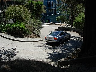
Lombard Street is an east–west street in San Francisco, California that is famous for a steep, one-block section with eight hairpin turns. Stretching from The Presidio east to The Embarcadero, most of the street's western segment is a major thoroughfare designated as part of U.S. Route 101. The famous one-block section, claimed to be "the crookedest street in the world", is located along the eastern segment in the Russian Hill neighborhood. It is a major tourist attraction, receiving around two million visitors per year and up to 17,000 per day on busy summer weekends, as of 2015.

South of Market (SoMa) is a neighborhood in San Francisco, California, situated just south of Market Street. It contains several sub-neighborhoods including South Beach, Yerba Buena, and Rincon Hill.

A hairpin turn is a bend in a road with a very acute inner angle, making it necessary for an oncoming vehicle to turn about 180° to continue on the road. It is named for its resemblance to a bent metal hairpin. Such turns in ramps and trails may be called switchbacks in American English, by analogy with switchback railways.
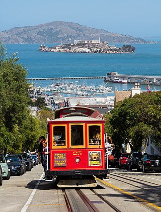
The San Francisco cable car system is the world's last manually operated cable car system and an icon of the city of San Francisco. The system forms part of the intermodal urban transport network operated by the San Francisco Municipal Railway, which also includes the separate E Embarcadero and F Market & Wharves heritage streetcar lines, and the Muni Metro modern light rail system. Of the 23 cable car lines established between 1873 and 1890, only three remain : two routes from downtown near Union Square to Fisherman's Wharf, and a third route along California Street.

Russian Hill is a neighborhood of San Francisco, California. It is named after one of San Francisco's 44 hills, and one of its original "Seven Hills".
The San Diego Creek bicycle path is the major bicycle backbone of the city of Irvine, California, which largely contains it. The path connects major points such as Newport Beach, University of California, Irvine, Boomers, Colonel Bill Barber Park, Irvine Civic Center, the Crossroads Shopping Center, Woodbridge High School, Woodbridge Community Park, Atria Senior Residential Area, Windrow Community Park and Irvine Medical Complex, before finally reaching Irvine Spectrum Center. It also runs through the majority of Irvine's neighborhoods such as Westpark, Woodbridge, and Oak Creek. The path begins where the San Diego Creek empties into Upper Newport Bay. The Bay itself makes for a pleasant ride with a Class 2 bike lane on the Eastern shore along a quiet road, some busy streets in the South and a section of Class 1 path to the east.
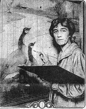
Rowena Fischer Meeks Abdy was an American modernist painter. She primarily painted landscapes and worked in Northern California.

A serpentine shape is any of certain curved shapes of an object or design, which are suggestive of the shape of a snake. Serpentine shapes occur in architecture, in furniture, and in mathematics.
The 49-Mile Scenic Drive is a designated scenic road tour highlighting much of San Francisco, California. It was created in 1938 by the San Francisco Down Town Association to showcase the city's major attractions and natural beauty during the 1939 Golden Gate International Exposition.
Vermont Street is a north–south street in the Potrero Hill district of San Francisco, one of a series of streets in the Potrero Hill district named after American battleships. It begins at Division Street near the South of Market area and runs south, paralleling the U.S. 101 freeway. At 22nd Street Vermont Street jumps to the other side of the freeway via a pedestrian bridge. That piece ends at 25th Street; Vermont resumes at 26th Street back on the east side of the freeway and continues to its south end at Cesar Chavez Street.

The city of Davenport, Iowa, United States has neighborhoods dating back to the 1840s. The Davenport Plan and Zoning Commission divided the city into five areas: downtown, central, east end, near north, and northwest and west end. The neighborhoods contain many architectural designs, including Victorian, Queen Anne, and Tudor Revival. Many of the original neighborhoods were first inhabited by German settlers.

Baker Street Mill is a grade II listed smock mill at Baker Street, Orsett, Essex, England which has been part adapted to residential use on its lower two floors only.
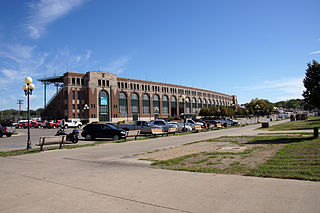
The Iowa State Fairgrounds is located on the east side of Des Moines, Iowa. It annually hosts the Iowa State Fair in late summer. The state fair was begun in Iowa in 1854 and the current fairgrounds were established in 1886. The fairgrounds were listed as an historic district on the National Register of Historic Places in 1987 as the Iowa State Fair and Exposition Grounds.
Crookedest street may refer to:

The Snake Alley Historic District is a nationally recognized historic district located in Burlington, Iowa, United States. It was listed on the National Register of Historic Places in 1975, and it was included in the Heritage Hill Historic District that surrounds it, in 1982. The historic district is largely a residential area that includes ten contributing properties. It is centered on Snake Alley, a 275-foot (84 m) brick roadway built in 1894 that rises 58.3 feet (18 m) from Washington Street to Columbia Street. The alley receives its name from the five half curves and two quarter curves that climb the hill. Cobblestone Alley is the eastern boundary of the district. It is a very steep roadway composed of large, limestone blocks. Six houses, built between 1845 and about 1880, surround Snake Alley. Schwartz' Auto Electric Service building and the First United Church of Christ complex round out the contributing buildings.

The Grade I listed building Walpole House is the largest, finest, and most complicated of the grand houses on Chiswick Mall, a waterfront street in the oldest part of Chiswick. Both the front wrought-iron screen and gate, and the back boundary wall, are Grade II listed.

Evergreen Cemetery is a burial ground located in Rutland Town, Vermont. It is managed by the Rutland Evergreen Cemetery Association. Evergreen was founded as Pine Hill Cemetery in 1861, and the name was subsequently changed.

