
Webster County is a county located in the west central portion of the U.S. state of Georgia. As of the 2020 Census reflected a population of 2,348, making it the third-least populous county in Georgia. The county seat is Preston.

Walton County is a county located in the Middle Georgia portion of the U.S. - State of Georgia. As of the 2020 census, the population was 96,673. It is located about 30 miles east of the state capital, the city of Atlanta. Monroe is the county seat; Loganville is another major city.

Walker County is a county located in the northwestern part of the U.S. state of Georgia. As of the 2020 census, the population was 67,654, down from 68,756 in 2010. The county seat is LaFayette. The county was created on December 18, 1833, from land formerly belonging to the Cherokee Indian Nation.

Pike County is a county located in the west central portion of the U.S. state of Georgia. As of the 2020 census, the population was 18,889. The county seat is Zebulon.

Newton County is a county located in the north central portion of the U.S. state of Georgia. As of the 2020 census, the population was 112,483. The county seat is Covington.

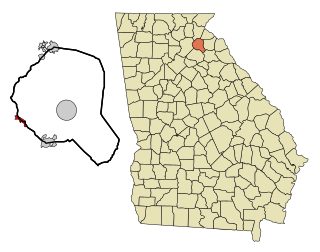
Jackson County is a county located in the northeastern part of the U.S. state of Georgia. As of the 2020 census, the population was 75,907. The county seat is Jefferson.

Franklin County is a county located in the northeastern part of the U.S. state of Georgia. As of the 2020 census, the population was 23,424. The county seat is Carnesville. On February 25, 1784, Franklin and Washington became Georgia's eighth and ninth counties, with Franklin named in honor of patriot Benjamin Franklin.
Floyd County is a county located in the northwestern part of the U.S. state of Georgia. As of the 2020 United States Census, the population was 98,584. The county seat is Rome.

Catoosa County is a county located in the northwestern part of the U.S. state of Georgia. As of the 2020 census, the population was 67,872. The county seat is Ringgold. The county was created on December 5, 1853. The meaning of the Cherokee language name "Catoosa" is obscure: "Catoosa" may come from the Cherokee words gatusi or gatu'gitse.
Gillsville is a city in Banks and Hall counties in the U.S. state of Georgia. The population was 235 at the 2010 census.

Lula is a city in Hall and Banks counties in the U.S. state of Georgia. Most of the city is in Hall County, with a small eastern portion of the city located in Banks County. The population was 2,822 at the 2020 census. The Hall County portion of Lula is part of the Gainesville, GA Metropolitan Statistical Area. Lula is the home of RailRoad Days, a yearly festival held usually every May. Lula is the railroad junction between the Atlanta northeast line and the Athens north line of Norfolk Southern Railway.

Braselton is a town in Barrow, Gwinnett, Hall, and Jackson counties in the U.S. state of Georgia, approximately 43 miles (69 km) northeast of Atlanta. As of the 2010 census, the town had a population of 7,511, and in 2018 the estimated population was 11,652.

Trenton is a city and the only incorporated municipality in Dade County, Georgia, United States—and as such, it serves as the county seat. The population was 2,195 at the 2020 census. Trenton is part of the Chattanooga, Tennessee–GA Metropolitan Statistical Area.

Redan is an unincorporated community and census-designated place (CDP) in DeKalb County, Georgia, United States. As of the 2020 census, the CDP had a total population of 31,749. It is a predominantly African American community in eastern DeKalb County, and is a suburb of Atlanta.

Blue Ridge is a city in Fannin County, Georgia, United States. As of the 2020 census, the city had a population of 1,253. The city is the county seat of Fannin County and the largest city in the county as well.

Union City is a city in Fulton County, Georgia, United States. The population was 26,830 at the 2020 census.

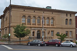
Clarkesville is a city that is the county seat of Habersham County, Georgia, United States. As of the 2020 census, it had a population of 1,911, up from the 2010 census population of 1,733, up from 1,248 at the 2000 census.

Zebulon is a city in Pike County, Georgia, United States. The population was 1,174 at the 2010 census. The city is the county seat of Pike County. The city and county were named after explorer Zebulon Pike.

Experiment is an unincorporated community and census-designated place (CDP) in Spalding County, Georgia, United States. The population was 3,233 at the 2000 census.

Sunbury is a city in Delaware County, Ohio, United States. The population was 6,614 at the 2020 census. Sunbury went from being a village to a city on October 22, 2021.


