Solana Valley

Last updated
Solana Valley
Valle de la Solana
051.Janovas - Plano general.JPG
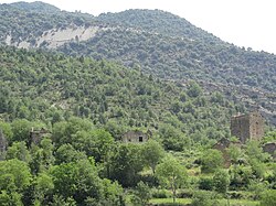
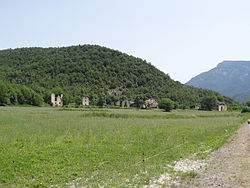
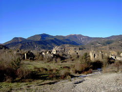
View of Jánovas, one of the abandoned villages in the Solana Valley.
Spain location map with provinces.svg
Red pog.svg
Solana Valley
Coordinates: 42°29′45″N0°1′30″W / 42.49583°N 0.02500°W / 42.49583; -0.02500 Coordinates: 42°29′45″N0°1′30″W / 42.49583°N 0.02500°W / 42.49583; -0.02500
Country Spain
Region Aragon
Elevation
850 m (2,790 ft)

Solana Valley (Spanish language Valle de la Solana; Aragonese language Val d'a Solana) is a valley in the Pyrenees. It is located in Aragon, Spain. River Ara cuts across the valley from east to west and its average altitude is 850 m.

Contents

History

There were many villages in Solana Valley. The inhabitants left the place between 1960 and 1970 owing to the pressure induced by ICONA, the Spanish National Institute for Forestal recovery that had bought the land surrounding the villages. [1] There were other factors as well, such as the abandonment of traditional agricultural practices like sheep and goat rearing, as well as the lifestyle changes that swept over rural Spain after General Franco's Plan de Estabilización that pulled the local youth towards the cities and the coast. [2]

Most of Solana Valley's territory depends administratively from Fiscal, Sobrarbe comarca, Huesca Province. [3]

Ghost towns

In Solana Valley there are numerous village churches and smaller religious buildings, such as the Iglesia de la Asunción and the exconjuratory in Burgasé, the Iglesia de Santa María in Muro de Solana, Santiago Church in Villamana and Saint Peter's Church in Gere. Many of the churches are in ruins.

The villages in the valley lie abandoned and the houses have fallen into disrepair and ruin:

Abandoned houses in Lavelilla. Lavelilla.JPG
Abandoned houses in Lavelilla.
View of Lacort. 2012 Lacort 02.JPG
View of Lacort.
Frescoes decaying in a ruined church of the valley 061.Janovas - pinturas de la pared.JPG
Frescoes decaying in a ruined church of the valley

See also

Related Research Articles

<span class="mw-page-title-main">Aragon</span> Autonomous community of Spain

Aragon is an autonomous community in Spain, coextensive with the medieval Kingdom of Aragon. In northeastern Spain, the Aragonese autonomous community comprises three provinces : Huesca, Zaragoza, and Teruel. Its capital is Zaragoza. The current Statute of Autonomy declares Aragon a historic nationality of Spain.

San Pedro is the Spanish language form of Saint Peter. It can refer to:

<span class="mw-page-title-main">Logroño</span> Municipality in La Rioja, Spain

Logroño is the capital of the province of La Rioja, situated in northern Spain. Traversed in its northern part by the Ebro River, Logroño has historically been a place of passage, such as the Camino de Santiago. Its borders were disputed between the Iberian kingdoms of Castille, Navarre and Aragon during the Middle Ages.

San Juan Bautista is the Spanish-language name of Saint John the Baptist. It may refer to:

<span class="mw-page-title-main">Comarcas of Spain</span> Divisions of some autonomous communities in Spain

In Spain, a comarca is either a traditional territorial division without any formal basis, or a group of municipalities, legally defined by an autonomous community for the purpose of providing common local government services. In English, a comarca is equivalent to a district, county, area or zone.

Jonacatepec de Leondro Valle is a city in the Mexican state of Morelos. The city serves as the municipal seat for the surrounding municipality of the same name. The municipality reported 15,690 inhabitants in the year 2015 census.

<span class="mw-page-title-main">Biescas</span> Place in Aragon, Spain

Biescas is a municipality of northeastern Spain close to the border with France, in the midst of the Pyrenees in the province of Huesca. The name seems to provide from the term bizka, which means "hill" in a Proto-Indo-European language.

<span class="mw-page-title-main">La Orotava</span> Municipality in Canary Islands, Spain

La Orotava is a town and a municipality in the northern part of Tenerife, one of the Canary Islands of Spain. The area of the municipality stretches from the north coast to the mountainous interior, and includes the summit of the Teide volcano, Canary Islands' and Spain's highest point at 3,718 m. At 207.31 km2, it is the largest municipality of the island of Tenerife. The population is 41,255 (2013).

<span class="mw-page-title-main">Oteiza</span>

Oteiza or Oteiza de la Solana, is a village and a Spanish municipality of the Foral Community of Navarra, located in the merindad of Estella, in the Estella Oriental region, 51 km from the capital of the community, Pamplona. Its population in 2016 was 939.

<span class="mw-page-title-main">La Vall d'Alcalà</span> Place in Denia

La Vall d'Alcalà is a valley in the Marina Alta region of Alicante, Spain.

<i>Repoblación</i> art and architecture

The designation artede (la) repoblación was first proposed by José Camón Aznar in 1949 to replace the term Mozarabic as applied to certain works of architecture from the Christian kingdoms of northern Spain between the end of the 9th and beginning of the 11th centuries. Camón argued that these buildings were related stylistically to the architecture of Asturias and owed little to Andalusian styles. Moreover, since they were built by Christians living under Christian rule, neither were they Mozarabic.

<span class="mw-page-title-main">Ateca</span> Place in Aragon, Spain

Ateca is a municipality located in the province of Zaragoza, Aragon, Spain. At the time of the 2015 census (INE), the municipality had a population of 1,969.

<span class="mw-page-title-main">Manchones</span> Municipality and village in Aragon, Spain

Manchones is a municipality in the province of Zaragoza, Aragon, Spain. According to the Spanish Statistical Institute (INE), the municipality had a population of 123 inhabitants in 2010. The pueblo is in the comarca of Campo de Daroca, about 6 kilometres (3.7 mi) northwest of Daroca and just southeast of Murero in the Calatayud-Daroca depression. The Jiloca River passes to the west.

<span class="mw-page-title-main">Sos del Rey Católico</span> Place in Aragon, Spain

Sos del Rey Católico is a historic town and municipality in the Cinco Villas comarca, province of Zaragoza, in Aragon, Spain.

<span class="mw-page-title-main">Tenango del Valle</span> Municipality in State of Mexico, Mexico

The municipality of Tenango del Valle is located in the southern portion of the Valley of Toluca in Mexico State, about 72 km southwest of Mexico City and 25 km south of Toluca. The municipal seat is the city of Tenango de Arista. While the seat is officially named Tenango de Arista, it is more commonly referred to as Tenango del Valle, as this was the original name of the town. Tenango del Valle is best known as the site of the Teotenango archeological site, which was a walled city inhabited from about 900 C.E. to 1550 C.E.

<span class="mw-page-title-main">Seno, Aragon</span> Place in Aragon, Spain

Seno is a municipality located in the Bajo Aragon area, close to Maestrazgo in province of Teruel, Aragon, Spain, at an altitude of 792 m. According to the 2018 census the municipality has a population of 39 inhabitants.

<span class="mw-page-title-main">Òrrius</span> Municipality in Catalonia, Spain

Òrrius is a village and municipality in the comarca of Maresme in the province of Barcelona and autonomous community of Catalonia, Spain. The municipality is delimited by La Roca del Vallès to the North, Vilassar de Dalt to the South East, Argentona to the south, and Cabrils to the southwest.

<span class="mw-page-title-main">Basilica of San Vicente</span> Spanish church

The Basílica de los Santos Hermanos Mártires, Vicente, Sabina y Cristeta, best known as Basílica de San Vicente, is a church in Ávila, Spain. It is one of the best examples of Romanesque architecture in the country.

<span class="mw-page-title-main">Fiscal, Aragon</span>

Fiscal is a municipality in the province of Huesca, Sobrarbe comarca, Aragon, Spain. It is located 76 kilometers from Huesca. It is 768 meters above sea level, and covers an area of 170 km². As of 2018, it had a population of 327 inhabitants.

<span class="mw-page-title-main">Ara Christi Charterhouse</span>

The Ara Christi Charterhouse, or the Cartuja de Ara Christi, is a former Carthusian monastery located just outside the town of El Puig in the province of Valencia, Spain. The site now includes a hotel and utilizes the facilities for functions.

References

  1. Menjón Ruiz, Marisancho, Jánovas, víctimas de un pantano de papel. Pirineum Editorial, Jaca, 2006. ISBN   84-935061-0-9
  2. Despoblación en Aragon Archived 2012-08-23 at the Wayback Machine
  3. Diario del AltoAragón (10 d'agost del 2009) - El valle de La Solana