South Bridge, Edinburgh

Last updated

South Bridge A7 South Bridge, Edinburgh - DSC06195.JPG
South Bridge
The largest arch of the bridge, seen from the Cowgate. MA(1829) p.195 - South Bridge, from the Cowgate - Thomas Hosmer Shepherd.jpg
The largest arch of the bridge, seen from the Cowgate.
Adam Square in Edinburgh Adam Square in Edinburgh.png
Adam Square in Edinburgh

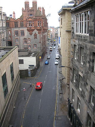
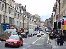
South Bridge is a road bridge and street in Edinburgh, Scotland, between the High Street, where it meets the North Bridge, to Nicolson Street at the south. It forms a continuous roadway over the steep valley scoured parallel to the High Street when the crag and tail landscape of the city was formed. The bridge dips down from the High Street to the Cowgate (the roadway along the bottom of the valley), which runs under the largest arch of the bridge, before climbing back up to its terminus at Nicolson Street.

Contents

The concept of the bridge was raised in 1784 by James Hunter Blair in his capacity as Lord Provost of Edinburgh, as a logical southward extension of the pre-existing North Bridge, which connected Edinburgh's Old Town to its New Town. The southward bridge, set on the same alignment, was to improve connection to the southward land, and spanned over the Cowgate. The works necessitated the loss of many buildings including the old Edinburgh Poultry Market. [1]

The bridge was designed by Robert Kay and built by Alexander Laing. [2]

The South Bridge Act 1785 was passed in the House of Commons of the United Kingdom on 21 April 1785 and in 1789 taxes were raised to fund the South Bridge to a plan prepared by Robert Adam. The foundation stone was laid on 1 August 1785 by George Gordon, Lord Haddo in his capacity as Grand Master Mason of Scotland. The incomplete bridge was opened to foot traffic on 19 November 1786 using planks of wood resting on the completed arches. [3]

The bridge was completed in 1788. [4] It is constructed of nineteen arches, but is almost entirely enclosed by buildings on both sides, exposing only the largest arch where the street crosses the Cowgate. Below deck level are many buildings and vaults, the latter are now something of a tourist attraction. Most of the buildings on the deck level have separate entrances (and sometimes entirely separate functions) at the level of the street passing below (the Cowgate) or parallel to the bridge (Niddry Street and Blair Street).

The only older element incorporated into the South Bridge streetscape was Adam Square, which occupied the extreme south-west section and was built around 1770. This section has been twice rebuilt since its demolition around 1870 to build Chambers Street.

In 2002 the "Cowgate Fire" destroyed a section of the original buildings in the south-west quadrant. This section has now been rebuilt as a hotel and supermarket.

The historic structure contains one interior of great significance: Goldsmiths Hall, a relatively intact room linked to the old trade guilds. This attic level space is wholly unseen from the exterior and is also now only accessed via a characterless corridor entered from Blair Street. [5]

Initially, town plans such as John Ainslie's 1804 map showed the street name as "South Bridge Street", [6] by the 1850s the name had been shortened to "South Bridge". [7]

See also

Related Research Articles

<span class="mw-page-title-main">Royal Mile</span> Collection of streets in Edinburgh

<span class="mw-page-title-main">Royal Botanic Garden Edinburgh</span> Botanical garden in Edinburgh, Scotland

The Royal Botanic Garden Edinburgh (RBGE) is a scientific centre for the study of plants, their diversity and conservation, as well as a popular tourist attraction. Founded in 1670 as a physic garden to grow medicinal plants, today it occupies four sites across Scotland—Edinburgh, Dawyck, Logan and Benmore—each with its own specialist collection. The RBGE's living collection consists of more than 13,302 plant species, whilst the herbarium contains in excess of 3 million preserved specimens.

<span class="mw-page-title-main">Cowgate</span> Street in Edinburgh, Scotland, UK

The Cowgate is a street in Edinburgh, Scotland, located about 550 yards (500 m) southeast of Edinburgh Castle, within the city's World Heritage Site. The street is part of the lower level of Edinburgh's Old Town, which lies below the elevated streets of South Bridge and George IV Bridge. It meets the Grassmarket at its west end and Holyrood Road to the east.

<span class="mw-page-title-main">Old College, University of Edinburgh</span> Building in Edinburgh, Scotland

Old College is a late 18th-century to early 19th-century building of the University of Edinburgh, Scotland. It is located on South Bridge, and presently houses parts of the University's administration, the University of Edinburgh School of Law, and the Talbot Rice Gallery.

<span class="mw-page-title-main">Edinburgh Vaults</span> Chambers under the South Bridge

The Edinburgh Vaults or South Bridge Vaults are a series of chambers formed in the nineteen arches of the South Bridge in Edinburgh, Scotland, was part of the South Bridge Act 1785 and was completed in 1788. For around 30 years, the vaults were used to house taverns, workshops for cobblers and other tradesmen, as well as storage space for said merchants. In later years, the vaults were a hotspot for the homeless and for criminal activity such as illegal gambling taverns, illegal whisky distillery and, according to rumour, bodysnatchers stored corpses there overnight. There is however no proof that the serial killers Burke and Hare ever used the vaults.

<span class="mw-page-title-main">Old Town, Edinburgh</span> The oldest part of Edinburgh

The Old Town is the name popularly given to the oldest part of Scotland's capital city of Edinburgh. The area has preserved much of its medieval street plan and many Reformation-era buildings. Together with the 18th/19th-century New Town, and West End, it forms part of a protected UNESCO World Heritage Site.

Easter Road is an arterial road in north Edinburgh, the capital of Scotland. The road is so called as it was known as the "Easter (eastern) road to Leith". As maps of Edinburgh in the late 18th century show, it had a counterpart in "Wester Road". Until the creation of Leith Walk in the middle of the 17th century these were the two main routes from Leith to Edinburgh. Historic personages who have ridden up Easter Road have included Mary, Queen of Scots (1561) and Oliver Cromwell.

<span class="mw-page-title-main">Regent Bridge</span> Arch bridge in Edinburgh, Scotland, UK

Regent Bridge is a road bridge in Edinburgh, Scotland, where the A1 road enters the New Town from the east and passes over a hollow near Calton Hill. The bridge was built in the 19th century, in the neoclassical style as the medieval city was modernised and expanded to the north and east.

<span class="mw-page-title-main">George IV Bridge</span> Road bridge in Edinburgh, Scotland

George IV Bridge is an elevated street in Edinburgh, Scotland, and is home to a number of the city's important public buildings.

<span class="mw-page-title-main">St Paul's and St George's Church</span> Church in Edinburgh, Scotland

St Paul's and St George's Church is an evangelical church of the Scottish Episcopal Church in central Edinburgh, Scotland. It is located on the corner of Broughton Street and York Place in the east end of Edinburgh's New Town, and is protected as a category A listed building.

<span class="mw-page-title-main">Great Junction Street</span>

Great Junction Street is a street in Leith, on the northern outskirts of Edinburgh, Scotland. It runs southeast to northwest following approximately the southwestmost line of the old town walls around Leith.

<span class="mw-page-title-main">Sir James Hunter Blair, 1st Baronet</span> Scottish banker, landowner and politician

Sir James Hunter Blair, 1st Baronet FRSE was a Scottish banker, landowner and politician.

<span class="mw-page-title-main">North Bridge, Edinburgh</span> Road bridge and street in Edinburgh linking the High Street with Princes Street

North Bridge is a road bridge and street in Edinburgh linking the High Street with Princes Street, and the Old Town with the New Town. The current bridge was built between 1894 and 1897. A previous North Bridge, built between 1763 and 1772, stood until 1896.

<span class="mw-page-title-main">Edinburgh town walls</span> City walls in City of Edinburgh, Scotland, UK

There have been several town walls around Edinburgh, Scotland, since the 12th century. Some form of wall probably existed from the foundation of the royal burgh in around 1125, though the first building is recorded in the mid-15th century, when the King's Wall was constructed. In the 16th century the more extensive Flodden Wall was erected, following the Scots' defeat at the Battle of Flodden in 1513. This was extended by the Telfer Wall in the early 17th century. The walls had a number of gates, known as ports, the most important being the Netherbow Port, which stood halfway down what is now the Royal Mile. This gave access from the Canongate which was, at that time, a separate burgh.

<span class="mw-page-title-main">St Cecilia's Hall</span> Music museum, concert hall in Edinburgh, Scotland

St Cecilia's Hall is a small concert hall and museum in the city of Edinburgh, Scotland, in the United Kingdom. It is on the corner of Niddry Street and the Cowgate, about 168 metres (551 ft) south of the Royal Mile. The hall dates from 1763 and was the first purpose-built concert hall in Scotland. It is a Category A listed building.

<span class="mw-page-title-main">Moray Estate</span>

The Moray Estate in Edinburgh was an exclusive early 19th century building venture attaching the west side of Edinburgh's New Town.

<span class="mw-page-title-main">Queen Street, Edinburgh</span>

Queen Street is the northernmost east-west street in Edinburgh's First New Town. It begins in the east, at the Scottish National Portrait Gallery. It links York Place with the Moray Estate.

Bellevue is a district of Edinburgh, the capital of Scotland. It lies to the south east of Canonmills, west of Leith Walk and south of Leith, incorporating the easternmost extent of Edinburgh's New Town UNESCO heritage site. The area was formerly open fields which became the second and penultimate location of the Royal Botanic Garden in 1763 .

<span class="mw-page-title-main">Buccleuch (parish), Edinburgh</span>

Buccleuch Parish, commonly known as the South Side is a district in south Edinburgh built as an expansion to the Old Town in the 18th century. The area lies between the Old Town and Newington.

<span class="mw-page-title-main">Robert Burn (architect)</span> Scottish architect

Robert Burn (1752–1815) was a Scottish architect. He was father to the architect William Burn.

References

  1. Grant's Old and New Edinburgh vol.2 p.373
  2. Buildings of Scotland: Edinburgh by Gifford, McWilliam and Walker
  3. Grant's Old and New Edinburgh vol.2 p.374
  4. "Edinburgh". Encyclopedia Britannica. Retrieved 20 February 2020.
  5. Buildings of Scotland: Edinburgh by Gifford, McWilliam and Walker
  6. John Ainslie (1804). "Old and New Town of Edinburgh and Leith with the proposed docks". Town Plans / Views, 1580-1919. National Library of Scotland. Retrieved 9 August 2020.
  7. Ordnance Survey (1852). "Town Plan of Edinburgh - Sheet 36". Town Plans / Views, 1580-1919. National Library of Scotland. Retrieved 9 August 2020.

55°56′58″N3°11′14″W / 55.94944°N 3.18722°W / 55.94944; -3.18722