
Padre Island National Seashore (PINS) is a national seashore administered by the National Park Service, located on Padre Island off the coast of South Texas, USA. In contrast to South Padre Island, known for its beaches and vacationing college students, PINS is located on the north end of Padre Island and consists of a long beach where nature is preserved.

Willacy County is a county in the U.S. state of Texas. As of the 2020 census, its population was 20,164. Its county seat is Raymondville. The county was created in 1911 and organized the next year.

Cameron County, officially the County of Cameron, is the southernmost county in the U.S. state of Texas. As of the 2020 census, its population was 421,017. Its county seat is Brownsville.

Port Huron Charter Township is a charter township of St. Clair County in the U.S. state of Michigan. The population was 10,792 at the 2020 Census. The city of Port Huron is adjacent to the township.
Bayview is a town in Cameron County, Texas, United States. The population was 475 at the 2020 census. It is part of the Brownsville–Harlingen–Raymondville and the Matamoros–Brownsville metropolitan areas.

El Camino Angosto is a census-designated place (CDP) in Cameron County, Texas, United States. The population was 186 at the 2020 census. It is part of the Brownsville–Harlingen Metropolitan Statistical Area.
Laguna Heights is a census-designated place (CDP) in Cameron County, Texas, United States. The population was 962 at the 2020 census, significantly down from 3,488 at the 2010 census.

Los Fresnos is a city in Cameron County, Texas, United States. The population was 8,114 at the 2020 census, up from 5,542 at the 2010 census. It is part of the Brownsville–Harlingen–Raymondville and the Matamoros–Brownsville metropolitan areas.

Olmito is a census-designated place (CDP) in Cameron County, Texas, United States. Olmito is Spanish for "little elm". The population was 1,021 at the 2020 census. It is part of the Brownsville–Harlingen Metropolitan Statistical Area. Olmito is the self-described "mesquite capital of the world."
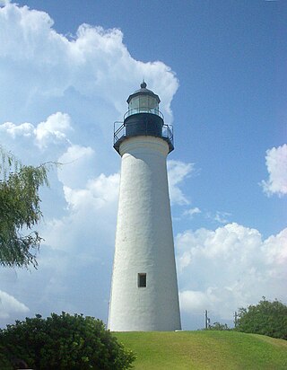
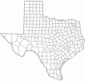
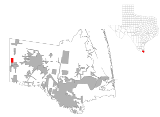
Port Isabel is a city in Cameron County, Texas, United States. It is part of the Brownsville–Harlingen–Raymondville and the Matamoros–Brownsville metropolitan areas. The population was 5,028 at the 2020 census.
Ratamosa is a census-designated place (CDP) in Cameron County, Texas, United States. The population was 197 at the 2020 census. It is part of the Brownsville–Harlingen Metropolitan Statistical Area.

South Padre Island is a resort town in Cameron County, Texas, United States. It is part of the Brownsville–Harlingen Metropolitan Statistical Area. The population was 2,066 at the 2020 census. The town is located on South Padre Island, a barrier island with the Laguna Madre situated to the leeward of the island and the Gulf of Mexico on the windward flank, along the Texas Gulf Coast. South Padre Island is accessible via the Queen Isabella Causeway from the town of Port Isabel. South Padre Island is named after José Nicolás Ballí, a Catholic priest and settler.

Port Mansfield is a census-designated place (CDP) in Willacy County, Texas, United States. The population was 226 at the 2010 census.

Padre Island is the largest of the Texas barrier islands and the world's longest barrier island. The island is located along Texas's southern coast of the Gulf of Mexico and is noted for its white sandy beaches. Meaning father in Spanish, it was named after Father José Nicolás Ballí (c.1770-1829), who owned the island and served as a missionary priest and collector of finances for all the churches in the Rio Grande Valley. He also founded the first mission in present-day Cameron County.

Mustang Island is a barrier island on the Gulf Coast of Texas in the United States. The island is 18 miles (29 km) long, stretching from Corpus Christi to Port Aransas. The island is oriented generally northeast–southwest, with the Gulf of Mexico on the east and south, and Corpus Christi Bay on the north and west. The island's southern end connects by roadway to Padre Island. At the northern end of the island is Port Aransas, beyond which is San José Island. The Aransas Channel, also known as the "Aransas Pass," which separates Mustang Island from San José Island, is protected by jetties extending into the Gulf from each island.
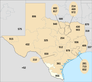
Area code 956 is a telephone area code in the North American Numbering Plan for the Lower and Middle Rio Grande Valley regions in the U.S. state of Texas. The numbering plan area includes the communities of Brownsville, McAllen, Laredo and South Padre Island. The area code was created May 25, 1997, in a split from area code 210.
North Padre Island is a barrier island along the coast of Texas. It and South Padre Island were formed after the creation of the Port Mansfield Channel split Padre Island in two. From north to south, North Padre Island is located in parts of Nueces, Kleberg, Kenedy, and Willacy counties. The northernmost part of the island to the Kleberg County line is part of the city of Corpus Christi. Padre Island was once one island —today it is two and referred as North Padre Island, and South Padre Island. Padre Island National Seashore welcomed 674,704 visitors in 2020. Padre Island National Seashore, (PINS) is a national park that includes about 66 miles of undeveloped beaches and natural habitat. PINS is the longest stretch of undeveloped barrier island in the world. PINS is a nesting ground for the Kemp’s ridley sea turtle, the most endangered sea turtle species in the world, which nests on the beach from late April through mid-July. PINS is situated along the Central Flyway, Padre Island is a globally important area for over 380 migratory, overwintering, and resident bird species. The national seashore is located on [North] Padre Island near the city of Corpus Christi, Texas. This national park is open 24 hours a day and seven days a week for visitors.

The Laguna Madre is a long, shallow, hypersaline lagoon along the western coast of the Gulf of Mexico in Nueces, Kenedy, Kleberg, Willacy and Cameron Counties in Texas, United States. It is one of seven major estuaries along the Gulf Coast of Texas. The roughly 20-mile (32 km) long Saltillo Flats land bridge divides it into Upper and Lower lagoons joined by the Intracoastal Waterway, which has been dredged through the lagoon. Cumulatively, Laguna Madre is approximately 130 miles (210 km) long, the length of Padre Island in the US. The main extensions include Baffin Bay in Upper Laguna Madre, Red Fish Bay just below the Saltillo Flats, and South Bay near the Mexican border. As a natural ecological unit, the Laguna Madre of the United States is the northern half of the ecosystem as a whole, which extends into Tamaulipas, Mexico approximately 144 miles (232 km) south of the US border, to the vicinity of the Rio Soto La Marina and the town of La Pesca, extending approximately 275 miles (443 km) through USA and Mexico in total.
Isla Blanca or Blanca Island and their plurals may refer to:

Brazos Santiago Pass is a natural coastal landform located in the Lower Laguna Madre and Lower Rio Grande Valley on the furthest southern beach terrain of the Texas Gulf Coast. The seacoast passage is interpolated by barrier islands encompassing the southern Brazos Island and the northern South Padre Island.

