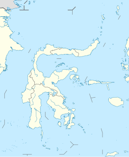
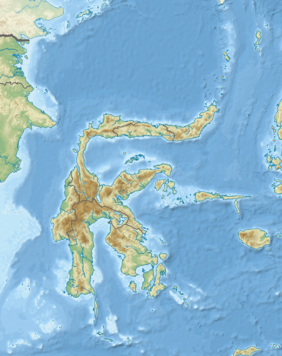
Sulawesi, also known as Celebes, is one of the four Greater Sunda Islands. It is governed by Indonesia. The world's eleventh-largest island, it is situated east of Borneo, west of the Maluku Islands, and south of Mindanao and the Sulu Archipelago. Within Indonesia, only Sumatra, Borneo and Papua are larger in territory, and only Java and Sumatra have larger populations.

Cave paintings are a type of parietal art, found on the wall or ceilings of caves. The term usually implies prehistoric origin, but cave paintings can also be of recent production: In the Gabarnmung cave of northern Australia, the oldest paintings certainly predate 28,000 years ago, while the most recent ones were made less than a century ago.

Central Sulawesi is a province of Indonesia located at the centre of the island of Sulawesi. The administrative capital and largest city is located in Palu. The 2010 census recorded a population of 2,635,009 for the province, and the 2015 Census of 2,872,859, while the latest official estimate is 3,042,100. Central Sulawesi has an area of 61,841.29 km2 (23,877 sq mi), the largest area among all provinces on Sulawesi Island, and has the second-largest population on Sulawesi Island after the province of South Sulawesi. It is bordered by the provinces of Gorontalo to the north, West Sulawesi, South Sulawesi and South East Sulawesi to the south, by Maluku to the east, and by the Makassar Strait to the west. The province is inhabited by many ethnic groups, such as the Kaili, Tolitoli, etc. The official language of the province is Indonesian, which is used for official purposes and inter-ethnic communication, while there are several indigenous language spoken by the Indigenous peoples of Central Sulawesi. Islam is the dominant religion in the province, followed by Christianity which are mostly adhered by the people in the eastern part of the province.
Buginese or Bugis is a language spoken by about five million people mainly in the southern part of Sulawesi, Indonesia.

South Sulawesi is a province in the southern peninsula of Sulawesi. The Selayar Islands archipelago to the south of Sulawesi is also part of the province. The capital is Makassar. The province is bordered by Central Sulawesi and West Sulawesi to the north, the Gulf of Bone and Southeast Sulawesi to the east, Makassar Strait to the west, and Flores Sea to the south.
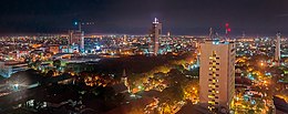
Makassar is the capital of the Indonesian province of South Sulawesi. It is the largest city in the region of Eastern Indonesia and the country's fifth-largest urban centre after Jakarta, Surabaya, Bandung, and Medan. From 1971 to 1999, the city was named after one of its subdistricts, Ujung Pandang. The city is located on the southwest coast of the island of Sulawesi, facing the Makassar Strait. Makassar is not only the gateway of Eastern Indonesia, but also the epicenter of West and East Indonesia, as well as between Australia and Asia.
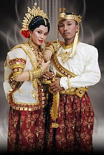
The Buginese or Bugis people are an ethnic group—the most numerous of the three major linguistic and ethnic groups of South Sulawesi, in the southwestern province of Sulawesi, third largest island of Indonesia. The Austronesian ancestors of the Bugis people settled on Sulawesi around 2500 B.C.E. There is "historical linguistic evidence of some late Holocene immigration of Austronesian speakers to South Sulawesi from Taiwan"—which means that the Buginese have "possible ultimate ancestry in South China", and that as a result of this immigration, "there was an infusion of an exogenous population from China or Taiwan." Migration from South China by some of the paternal ancestors of the Bugis is also supported by studies of Human Y-chromosome DNA haplogroups. The Bugis in 1605 converted to Islam from Animism. Some Buginese have retained their pre-Islamic belief called Tolotang, and some Bugis converted to Christianity by means of marriage; but they have remained a minority.

Bone was a Bugis sultanate in the south-west peninsula of Sulawesi, now part of modern-day Indonesia. Covering an area of 2,600 square kilometres (1,000 sq mi), Bone's chief town Watampone, lies 130 kilometres (81 mi) northeast of the city of Makassar. Its rulers were called the arumpone or the arung (ruler) of Bone.
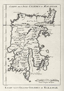
The Kingdom of Luwu is generally thought to be the oldest kingdom in South Sulawesi. In 1889, the Dutch Governor of Makassar placed Luwu's heyday between the 10th and 14th centuries, but offered no evidence. The La Galigo, an epic poem composed in a literary form of the Bugis language, is the likely inspiration of Braam Morris’ dating. The La Galigo depicts a vaguely defined world of coastal and riverine kingdoms whose economies are based on trade. Two early centres of this world are Luwu and the kingdom of Cina in what is now Wajo. The incompatibility of the La Galigo's trade-based political economy with the agricultural economies of other South Sulawesi kingdoms has led scholars to posit an intervening period of chaos to separate the two societies chronologically.

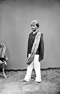
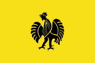
Sultan Hasanuddin was the 16th Ruler of The Sultanate of Gowa as Sombaya Ri Gowa XVI from 1653 to 1669. He was proclaimed as Indonesian National Hero on 6 November 1973. The Dutch called Sultan Hasanuddin "the Rooster of the East" as he was described as aggressive in battle.
The Makassar people are an ethnic group that inhabits the southern part of the South Peninsula, Sulawesi in Indonesia. They live around Makassar, the capital city of the province of South Sulawesi, as well as the Konjo highlands, the coastal areas, and the Selayar and Spermonde islands. They speak Makassarese, which is closely related to Buginese and also a Malay creole called Makassar Malay.

Caves in the Maros-Pangkep karst are situated in South Sulawesi, Indonesia and contain paintings from the paleolithic considered to be the earliest figurative art in the world.
Sultanate of Gowa was one of the great kingdoms and the most successful kingdom in the South Sulawesi region. People of this kingdom come from the Makassar tribe who lived in the south end and the west coast of southern Sulawesi.
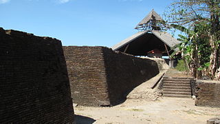
Fort Somba Opu was a fortified commercial center of the Gowa Sultanate. Its ruins are located in Makassar, South Sulawesi, Indonesia. The fort was the center of the Gowa Sultanate in the 16th-century until its destruction by the Dutch East India Company in 1669. The conquest of Somba Opu citadel was one of the most difficult campaigns the Company had ever undertaken in the East.
The Makassar kingdom of Gowa emerged around 1300 CE as one of many agrarian chiefdoms in the Indonesian peninsula of South Sulawesi. From the sixteenth century onward, Gowa and its coastal ally Talloq became the first powers to dominate most of the peninsula, following wide-ranging administrative and military reforms, including the creation of the first bureaucracy in South Sulawesi. The early history of the kingdom has been analyzed as an example of state formation.

Arung Palakka, or La Tenritatta to Unru' was a 17th-century Bugis prince and warrior. He supported the Dutch East India Company (VOC) in the Makassar War (1666–1669) against the Gowa Sultanate in his native South Sulawesi. After the defeat of Gowa, he became the King of Bone and South Sulawesi's most powerful man.
The Kingdom of Tallo was one of the two kingdoms of Makassar in South Sulawesi from the 15th century to 1856. The state stood in a close political relation to the Sultanate of Gowa. After the Islamization of the Gowa and Tallo kingdoms in the early 17th century, they were usually collectively known as the Makassar Kingdom.
Ajatappareng was a historical region in the western part of South Sulawesi consisting of five allied principalities: Sidenreng, Suppa, Rappang, Sawitto, and Alitta. They formed an alliance during the sixteenth century in response to the rise of Gowa and Tallo to the south and rivalling the Telumpoccoe alliance—consisting three Bugis kingdoms of Bone, Wajo, and Soppeng—to the east. The Ajatappareng confederation became a regional power and a major port thanks to its naval power and the exodus of traders fleeing the Portuguese capture of Malacca. The confederation's power declined in the seventeenth century, when it was subjugated by Gowa. The later invasion of South Sulawesi by the Dutch East India Company and its imposition of monopoly ended the region's status as a trade centre.