Special routes of U.S. Route 61

Last updated

US 61.svg


Special routes of U.S. Route 61
Highway system

Several special routes of U.S. Route 61 exist in the states of Louisiana, Mississippi, Missouri, and Iowa.

Contents

Business routes

Baton Rouge, Louisiana

Business plate.svg

US 61.svg

U.S. Highway 61 Business

Location Baton Rouge, Louisiana
Length10.803 mi [1]  (17.386 km)
Existed1954–present

U.S. Highway 61 Business (US 61 Bus.) runs 10.80 miles (17.38 km) through Baton Rouge, the capital city of Louisiana. [2] The route is entirely concurrent with US 190 Bus., forming a loop off of mainline US 61/US 190 (Airline Highway) through the downtown area. The business route was first put into effect in 1954 and assumed its current alignment in 1960. [3]

The entire highway is in Baton Rouge, East Baton Rouge Parish.

mi [1] kmDestinationsNotes
0.000–
0.201
0.000–
0.323
US 61.svgWest plate.svg
US 190.svg
US 61  / US 190 west (Airline Highway) New Orleans, Opelousas, Natchez
East plate.svg
US 190.svg
US 190 east (Florida Boulevard) Hammond
Begin plate.svg
Business plate.svg
US 190.svg
US 190 Bus. begins
Interchange; southern terminus of US 61 Bus.; eastern terminus of US 190 Bus.; southern end of US 190 Bus. concurrency
4.1926.746Louisiana 67 (2008).svg LA 67 (North 22nd Street)
5.009–
5.090
8.061–
8.192
North plate blue.svg
I-110.svg
I-110 north Metro Airport, Natchez
South plate blue.svg
I-110.svg
To plate blue.svg
East plate blue.svg
I-10.svg
To plate blue.svg
I-12.svg
I-110 south to I-10 east / I-12  New Orleans, Hammond
Exit 1C on I-110; direct access limited to I-110 (north) to US 61 Bus. (south) and US 61 Bus. (both directions) to I-110 (south)
8.34213.425Louisiana 3164 (2008).svg LA 3164 (Scenic Highway)Northern terminus of LA 3164
10.756–
10.803
17.310–
17.386
North plate.svg
US 61.svg
US 61 north (Scenic Highway) Scotlandville, St. Francisville
South plate.svg
US 61.svg
US 190.svg US 61 south (Airline Highway) / US 190  Opelousas, Natchez
End plate.svg
Business plate.svg
US 190.svg
US 190 Bus. ends
Interchange; northern terminus of US 61 Bus.; western terminus of US 190 Bus.; northern end of US 190 Bus. concurrency
1.000 mi = 1.609 km; 1.000 km = 0.621 mi

St. Francisville, Louisiana

Business plate.svg

US 61.svg

U.S. Highway 61 Business

Location St. Francisville, Louisiana
Length1.729 mi [4]  (2.783 km)
Existedc.1959c.2013
KML is not from Wikidata

U.S. Highway 61 Business (US 61 Bus.) ran 10.73 miles (17.27 km) through St. Francisville, a town in West Feliciana Parish, Louisiana. [5] The route followed a portion of former US 61 that was bypassed by the current alignment around 1959. Like several other special routes in Louisiana, the designation was unofficial, not recognized by AASHTO or printed on the official state highway maps. It was signed along portions of LA 3057 (Commerce Street) and LA 10 (Jackson Road). Signage was removed around 2013 when new highway markers were installed following the widening of mainline US 61 to four lanes and a change in several highway designations in the area. [5]

The entire highway was in St. Francisville, West Feliciana Parish.

mi [4] kmDestinationsNotes
0.0000.000US 61.svg US 61  Baton Rouge, Natchez
Begin plate.svg
Louisiana 3057 (2008).svg
LA 3057 begins
Southern terminus of US 61 Bus. and LA 3057; southern end of LA 3057 concurrency
0.9741.568West plate.svg
Louisiana 10 (2008).svg
LA 10 west (Ferdinand Street)
Southern end of LA 10 concurrency
1.4122.272North plate.svg
Louisiana 3057 (2008).svg
LA 3057 north (Commerce Street)
Northern end of LA 3057 concurrency
1.693–
1.729
2.725–
2.783
US 61.svg US 61  Baton Rouge, Natchez
East plate.svg
Louisiana 10 (2008).svg
LA 10 east Jackson
Northern end of LA 10 concurrency
1.000 mi = 1.609 km; 1.000 km = 0.621 mi

Natchez, Mississippi

Business plate.svg

US 61.svg

U.S. Highway 61 Business

Location Natchez, Mississippi

US 61 BUS in Natchez, MS uses part of US 425/US 84, then turns onto Homochitto Street. US 61 BUS turns right onto South Martin Luther King Jr. Street. US 61 BUS then turns onto a pair of one way streets concurrent with former US 84 BUS (East Franklin Street northbound; Saint Cathrine Street southbound); Mississippi Highway 555 continues northward. The routes then merge into a divided highway before meeting mainline US 61/US 84.

The entire route is in Natchez, Adams County.

mikmDestinationsNotes
US 61.svgEast plate.svg
US 84.svg
Begin plate.svg
US 425.svg
US 61  / US 84 east / US 425 begins Baton Rouge, Vicksburg
Southern terminus; south end of US 84/US 425 concurrency
West plate.svg
US 84.svg
North plate.svg
US 425.svg
US 84 west / US 425 north Alexandria
North end of US 84/US 425 concurrency
Begin plate.svg
Ellipse sign 930.svg
Begin plate.svg
Ellipse sign 932.svg
MS 930 begins / MS 932 begins
Western terminus of MS 930/MS 932; south end of MS 930/MS 932 concurrency
US 61.svgUS 84.svgNorth plate.svg
Ellipse sign 555.svg
End plate.svg
Ellipse sign 930.svg
End plate.svg
Ellipse sign 932.svg
US 61  / US 84  / MS 555 north / MS 930 ends / MS 932 ends Vicksburg, Baton Rouge
Northern terminus; southern terminus of northern segment of MS 555; eastern terminus of MS 930/MS 932; north end of MS 930/MS 932 concurrency
1.000 mi = 1.609 km; 1.000 km = 0.621 mi

Vicksburg, Mississippi

Business plate.svg

US 61.svg

U.S. Highway 61 Business

Location Vicksburg, Mississippi
Length12.3 mi [6]  (19.8 km)

U.S. Highway 61 Business (US 61 Bus.) is a business route in Vicksburg, Mississippi.

The entire route is in Warren County.

LocationmikmDestinationsNotes
US 61.svg US 61  Natchez, Vicksburg Southern terminus; no access to US 61 northbound from US 61 Bus southbound
Vicksburg I-20.svgUS 80.svg I-20  / US 80  Jackson, Monroe I-20 exit 1A
US 61.svg US 61  Vicksburg, Greenville Northern terminus
1.000 mi = 1.609 km; 1.000 km = 0.621 mi

Bowling Green, Missouri

Business plate.svg

US 61.svg

U.S. Route 61 Business

Location Bowling Green, Missouri
Length4.468 mi [7]  (7.191 km)

U.S. Route 61 BUS. in Bowling Green, MO is a four mile long business route of US 61. It intersects with US 54 Business in Bowling Green.

New London, Missouri

Business plate.svg

US 61.svg

U.S. Route 61 Business

Location New London, Missouri
Length1.914 mi [7]  (3.080 km)

U.S. 61 Business is a two mile business loop in New London, Missouri.

Palmyra, Missouri

Business plate.svg

US 61.svg

U.S. Route 61 Business

Location Palmyra, Missouri
Length3.648 mi [7]  (5.871 km)

U.S. 61 Business is a four mile business loop in Palmyra, Missouri.

La Grange, Missouri

Business plate.svg

US 61.svg

U.S. Route 61 Business

Location La Grange, Missouri
Length4.725 mi [7]  (7.604 km)

U.S. 61 Business is a five mile business loop in La Grange, Missouri.

Canton, Missouri

Business plate.svg

US 61.svg

U.S. Route 61 Business

Location Canton, Missouri
Length4.938 mi [7]  (7.947 km)

U.S. 61 Business is a five mile business loop in Canton, Missouri.

Keokuk, Iowa

Business plate.svg

US 61 (1961).svg

U.S. Highway 61 Business

Location Keokuk, Iowa
Length5.931 mi (9.545 km)

U.S. Route 61 Business (US 61 Business) begins west of Keokuk at the eastern intersection of US 136 and US 61 just north of their crossing into Iowa from Missouri over the Des Moines River. As it travels into Keokuk, it follows US 136 and the two routes run parallel to the Mississippi River just to the south. At the southern end of downtown Keokuk, US 136 turns to the southeast to travel across the Keokuk–Hamilton Bridge to Illinois. This intersection is also the southern end of US 218. US 61 Business turns north to follow US 218 out of the city. The two routes meet up with US 61 on the northwestern end of town and the business route ends. [8] The entire route is in Keokuk, Lee County.

mi [9] kmDestinationsNotes
0.0000.000West plate.svg
US 136.svg
US 61.svg US 136 west / US 61  Fort Madison
Southern end of US 136 overlap
2.4513.945East plate.svg
US 136.svg
Begin plate.svg
US 218.svg
US 136 east / US 218 begins (Main Street)
Northern end of US 136 overlap; southern end of US 218 overlap
5.9319.545North plate.svg
US 61.svg
North plate.svg
US 218.svg
US 61 north / US 218 north Fort Madison
Northern end of US 218 overlap
1.000 mi = 1.609 km; 1.000 km = 0.621 mi

Fort Madison, Iowa

Business plate.svg

US 61 (1961).svg

U.S. Highway 61 Business

Location Fort Madison, Iowa
Length9.075 mi [9]  (14.605 km)
Existed2012–present

U.S. Route 61 Business was created through Fort Madison, Iowa, along the former routing of US 61. The main route was rerouted around town along a new four-lane bypass in 2012. It begins at the interchange with Iowa Highway 2 (Iowa 2) west of Fort Madison. The two routes run east together into town. Iowa 2 splits away to cross the river near downtown and the route turns north and heads out of town. It ends at another interchange with US 61 northeast of town. From 2011 to 2013, the portion of highway north of Iowa 2 was known officially as Iowa 961, but it was not signed as such.

The entire route is in Lee County.

Locationmi [9] kmDestinationsNotes
Jefferson Township 0.0000.000US 61.svgCircle sign 2.svg US 61  / Iowa 2  / Mormon Pioneer National Historic Trail  Keokuk, Burlington
Fort Madison 3.9066.28618th StreetFormerly Iowa 103
4.1996.75815th StreetFormerly Iowa 88
5.4628.790To plate.svg
Illinois 9.svg
To plate.svg
Illinois 96.svg
To IL 9  / IL 96  / Mormon Pioneer National Historic Trail
Former end of Iowa 2
Washington Township 9.07514.605US 61.svg US 61  Burlington, Keokuk
1.000 mi = 1.609 km; 1.000 km = 0.621 mi

Muscatine, Iowa

Business plate.svg

US 61 (1961).svg

U.S. Highway 61 Business

Location Muscatine, Iowa
Length5.407 mi (8.702 km)
Existed1984–present

U.S. Highway 61 Business was created in 1984 after U.S. Highway 61 (US 61) was rerouted around Muscatine on a new four-lane bypass. It begins on the southern edge of Muscatine at the intersection of US 61 and Iowa Highway 92 (Iowa 92). US 61 Business heads north through Muscatine's industrial area and into the downtown riverfront. It is joined by Iowa 38 and Iowa 92 at an intersection near the foot of the Norbert F. Beckey Bridge. The intersection marks the southern end of Iowa 38 while Iowa 92 crosses the bridge into Illinois. A few blocks later, the three routes are joined by Iowa 22. All four routes continue north for a mile before meeting US 61.

The entire route is in Muscatine, Muscatine County.

mi [10] kmDestinationsNotes
0.0000.000US 61.svgElongated circle 92.svgSouth plate Vermont.svg
GreatRiverRoad.svg
US 61  / Iowa 92  / Great River Road south Wapello, Columbus Junction
3.2095.164Cedar StreetFormer western Iowa 22 junction
3.7816.085Begin plate.svg
Elongated circle 38.svg
East plate.svg
Elongated circle 92.svg
Iowa 38 begins / Iowa 92 east
Southern end of Iowa 38 and Iowa 92 overlaps
4.4987.239East plate.svg
Elongated circle 22.svg
North plate Vermont.svg
GreatRiverRoad.svg
Iowa 22 east / Great River Road north (Washington Street)
Northern end of Great River Road overlap; southern end of Iowa 22 overlap
5.4078.702US 61.svgWest plate.svg
Elongated circle 22.svg
West plate.svg
Elongated circle 92.svg
US 61  / Iowa 22 west / Iowa 92 west Blue Grass, Wapello
North plate.svg
Elongated circle 38.svg
Iowa 38 north Wilton
Northern end of Iowa 22 and Iowa 92 overlaps
1.000 mi = 1.609 km; 1.000 km = 0.621 mi

Davenport, Iowa

Business plate.svg

US 61 (1961).svg

U.S. Highway 61 Business

Location Davenport, Iowa
Length10.924 mi (17.580 km)
Existed2010–present

U.S. Route 61 Business was created in 2010 when U.S. Route 61 was rerouted around Davenport on I-280 and I-80. The route begins on the southwestern end of town at the interchange with I-280. From there, it heads towards the Mississippi River along River Drive. For six blocks, US 61 Bus. is overlapped by US 67, which joins from the south at the Centennial Bridge and parts to the north when US 61 Bus. turns off. For the most of the remaining trip through Davenport, the route runs along two one-way streets: Brady Street (northbound) and Harrison Street (southbound). Near 5th Street in downtown Davenport, the Iowa Interstate Railroad crosses over Brady and Harrison streets. The vertical clearance of both bridges is only 11 feet 8 inches (3.56 m), which causes many trucks that attempt to pass beneath the bridge to hit or become stuck. This bridge was a major factor in US 61's realignment. Just south of Kimberly Road, which carries US 6, the southbound lanes of US 61 Bus. turn onto Harrison Street from Welcome Way. North of 53rd Street, the two directions rejoin as one road. The route ends at the I-80 interchange on the northern side of town. [11] The entire route is inventoried as Iowa Highway 461, but it not signed as such. [12]

This low bridge was one of reasons US 61 relocated onto the interstates around Davenport Truck Eating Bridge (Davenport, Iowa).jpg
This low bridge was one of reasons US 61 relocated onto the interstates around Davenport

The entire route is in Davenport, Scott County.

mi [9] kmDestinationsNotes
0.0000.000I-280.svgUS 61.svg I-280  / US 61 to I-80
1.6412.641West plate.svg
Elongated circle 22.svg
South plate Vermont.svg
GreatRiverRoad.svg
Iowa 22 west / Great River Road south Buffalo
Southern end of Great River Road overlap
5.4358.747South plate.svg
US 67.svg
US 67 south (Centennial Bridge)
Southern end of US 67 overlap
5.6119.030North plate.svg
US 67.svg
North plate Vermont.svg
GreatRiverRoad.svg
US 67 north / Great River Road north (River Drive)
Northern end of US 67 and Great River Road overlap
8.41213.538US 6.svg US 6 (Kimberly Road)
10.92417.580I-80.svgUS 61.svg I-80  / US 61
1.000 mi = 1.609 km; 1.000 km = 0.621 mi

Maquoketa, Iowa

City Route 61.svg

U.S. Highway 61 Business

Location Maquoketa, Iowa
Length2.55 mi (4.10 km)
Existed1998–present

The business route through Maquoketa follows Main Street through the downtown business district, and Iowa Highway 64 along Platt Street. The route is unsigned, aside from a few circle "City Route 61" signs along Main Street.

Although not designated until 1998, Main Street had essentially served as a "Business 61" since at least the mid-1970s, when U.S. 61 was moved to a two-lane bypass around the south and west parts of the city. The bypass was widened to four-lane freeway in the summer of 1996, as part of a massive four-lane project of U.S. 61 between Dubuque and De Witt.

The entire route is in Maquoketa, Jackson County.

mi [13] kmDestinationsNotes
0.000.00US 61.svg US 61  Dubuque, Davenport
1.662.67East plate.svg
Elongated circle 64.svg
Iowa 64 east Preston
Southern end of Iowa 64 overlap
2.554.10US 61.svgWest plate.svg
Elongated circle 64.svg
US 61  / Iowa 64 west Dubuque, Anamosa, Davenport
Northern end of Iowa 64 overlap
1.000 mi = 1.609 km; 1.000 km = 0.621 mi

Bypass route

Baton Rouge, Louisiana

By-pass plate.svg

US 61 (1961).svg

U.S. Highway 61 Bypass

Location Baton Rouge
Length6.7 mi [14]  (10.8 km)
Existedc.1941c.1963

U.S. Highway 61 Bypass (US 61 Byp.) ran 6.7 miles (10.8 km) through Baton Rouge, the capital city of Louisiana. [14] It followed the Airline Highway, a four-lane bypass of the downtown area constructed in 1941. The designation remained in effect until about 1963, when its route was assumed by mainline US 61. [3] [15]

The entire highway was in Baton Rouge, East Baton Rouge Parish.

mi [14] kmDestinationsNotes
0.00.0South plate 1961.svg
US 61 (1961).svg
US 61 south (Airline Highway) New Orleans
East plate 1961.svg
US 190 (1961).svg
North plate.svg
Business plate.svg
US 61 (1961).svg
West plate.svg
Business plate.svg
US 190 (1961).svg
US 190 east / US 61 Bus. north / US 190 Bus. west (Florida Boulevard) Baton Rouge, Hammond
Begin plate.svg
By-pass plate.svg
US 190 (1961).svg
US 190 Byp. begins
Traffic circle; southern terminus of US 61 Byp.; eastern terminus of US 190 Byp.; southern end of US 190 Byp. concurrency
2.03.2Louisiana 37 (1955).svg LA 37 (Greenwell Springs Road) Greenwell Springs
5.48.7Louisiana 67 (1955).svg LA 67 (Plank Road) Clinton
6.710.8North plate 1961.svg
US 61 (1961).svg
South plate.svg
Business plate.svg
US 61 (1961).svg
East plate.svg
Business plate.svg
US 190 (1961).svg
US 61 north / US 61 Bus. south / US 190 Bus. east (Scenic Highway) Baton Rouge, Natchez
West plate 1961.svg
US 190 (1961).svg
US 190 west (Airline Highway) Opelousas
End plate.svg
By-pass plate.svg
US 190 (1961).svg
US 190 Byp. ends
Interchange; northern terminus of US 61 Byp.; western terminus of US 190 Byp.; northern end of US 190 Byp. concurrency
1.000 mi = 1.609 km; 1.000 km = 0.621 mi

Spur routes

New Madrid, Missouri

Spur plate.svg

US 61.svg

U.S. Route 61 Spur

Location New Madrid, Missouri
Length0.495 mi [7]  (797 m)

Bowling Green, Missouri

Spur plate.svg

US 61.svg

Main Street

Location Bowling Green, Missouri
Length0.460 mi (740 m)

US 61 Spur is an unsigned spur route of US 61 Business in Bowling Green, Missouri. It runs from the Bus. 61/Route Y junction to Route AA (Main Cross Street). This route is also known as Main Street. [16]

Related Research Articles

<span class="mw-page-title-main">U.S. Route 61</span> Highway in the United States

U.S. Route 61 or U.S. Highway 61 (U.S. 61) is a major United States highway that extends 1,400 miles (2,300 km) between New Orleans, Louisiana and the city of Wyoming, Minnesota. The highway generally follows the course of the Mississippi River and is designated the Great River Road for much of its route. As of 2004, the highway's northern terminus in Wyoming, Minnesota, is at an intersection with Interstate 35 (I-35). Until 1991, the highway extended north on what is now Minnesota State Highway 61 through Duluth to the Canada–U.S. border near Grand Portage, then continued to Thunder Bay, Canada, as Ontario Highway 61. Its southern terminus in New Orleans is at an intersection with U.S. Route 90. The route was an important south–north connection in the days before the interstate highway system.

<span class="mw-page-title-main">U.S. Route 171</span> United States Numbered Highway in Louisiana

U.S. Highway 171 (US 171) is a part of the United States Numbered Highway System and the only route within that system currently located entirely within the state of Louisiana. It spans 177.44 miles (285.56 km) in a north–south direction from the junction of US 90 and Louisiana Highway 14 (LA 14) in Lake Charles to the junction of US 79/US 80 and LA 3094 in Shreveport.

<span class="mw-page-title-main">U.S. Route 190</span> Highway in the United States

U.S. Route 190 (US 190) is an east–west United States Highway in Louisiana and Texas. Segments of US 190 will be upgraded to Interstate 14 (I-14); the first 24.8-mile (39.9 km) segment was opened on January 26, 2017.

<span class="mw-page-title-main">U.S. Route 218</span> Highway in the United States

U.S. Highway 218 (US 218) is an original United States Highway that was created in 1926. Although technically a spur of US 18, US 218 neither begins nor ends at US 18, but overlaps US 18 for eight miles (13 km) near Charles City, Iowa. US 218 begins at U.S. 136 in downtown Keokuk and ends 319 miles (513 km) away at Interstate 35 (I-35) and US 14 at Owatonna, Minnesota. A large portion of US 218 in Iowa is part of the Avenue of the Saints, which connects St. Louis, Missouri, and Saint Paul, Minnesota.

<span class="mw-page-title-main">Interstate 110 (Louisiana)</span> Highway in Louisiana

Interstate 110 (I-110) is an auxiliary Interstate Highway in the U.S. state of Louisiana. It runs 9.06 miles (14.58 km) in a north–south direction as a spur of I-10 in the city of Baton Rouge.

<span class="mw-page-title-main">Louisiana Highway 1</span> Highway in Louisiana

Louisiana Highway 1 (LA 1) is a state highway in Louisiana. At 431.88 miles (695.04 km), it is the longest numbered highway of any class in Louisiana. It runs diagonally across the state, connecting the oil and gas fields near the island of Grand Isle with the northwest corner of the state, north of Shreveport.

<span class="mw-page-title-main">Iowa Highway 92</span> Highway in Iowa

Iowa Highway 92 (Iowa 92) is a state highway that runs from east to west across the state of Iowa. Iowa 92 is 279 miles (449 km) long and is part of a continuous 886-mile (1,426 km) four-state "Highway 92" which begins in Torrington, Wyoming, goes through Nebraska and Iowa and ends in La Moille, Illinois. It begins at the Missouri River in Council Bluffs, where it is a continuation of Nebraska Highway 92. It stretches across the state and serves to roughly demarcate the southern one-third of Iowa. It ends at the Mississippi River in Muscatine where it continues into Illinois as Illinois Route 92. Iowa 92 was designated in 1939 replacing the entirety of the original Iowa 2.

<span class="mw-page-title-main">Louisiana Highway 10</span> State highway in Louisiana, United States

Louisiana Highway 10 (LA 10) is a state highway located in southern Louisiana. It runs 255.51 miles (411.20 km) in an east–west direction from U.S. Highway 171 (US 171) south of Leesville to the Mississippi state line east of Bogalusa.

<span class="mw-page-title-main">Louisiana Highway 6</span> State highway in Louisiana, United States

Louisiana Highway 6 (LA 6) is a state highway located in western central Louisiana. It runs 54.52 miles (87.74 km) in an east–west direction from the Texas state line southwest of Many to U.S. Highway 71 (US 71) and U.S. Highway 84 (US 84) in Clarence.

<span class="mw-page-title-main">Louisiana Highway 14</span> Highway in Louisiana

Louisiana Highway 14 (LA 14) is a state highway located in southern Louisiana. It runs 100.10 miles (161.10 km) in an east–west direction from the junction of U.S. Highways 90 and 171 in Lake Charles to LA 182 in New Iberia.

<span class="mw-page-title-main">Louisiana Highway 19</span> Highway in Louisiana

Louisiana Highway 19 (LA 19) is a state highway located in southeastern Louisiana. It runs 33.93 miles (54.61 km) in a north–south direction from U.S. Highway 61 (US 61) in Baton Rouge to the Mississippi state line north of Norwood.

<span class="mw-page-title-main">Louisiana Highway 30</span> State highway in Louisiana, United States

Louisiana Highway 30 (LA 30) is a state highway located in southeastern Louisiana. It runs 28.10 miles (45.22 km) in a northwest to southeast direction from LA 73 in Baton Rouge to the junction of U.S. Highway 61 (US 61) and LA 431 east of Gonzales.

<span class="mw-page-title-main">U.S. Route 51 in Louisiana</span> Section of U.S. Highway in Louisiana, United States

U.S. Highway 51 (US 51) is a part of the United States Numbered Highway System that spans 1,277 miles (2,055 km) from LaPlace, Louisiana to a point north of Hurley, Wisconsin. Within the state of Louisiana, the highway travels 69.12 miles (111.24 km) from the national southern terminus at US 61 in LaPlace to the Mississippi state line north of Kentwood.

<span class="mw-page-title-main">Special routes of U.S. Route 65</span>

A total of eight special routes of U.S. Route 65 exist, divided between the U.S. states of Arkansas and Missouri. Currently, they are all business loops, although a spur route in Pine Bluff, Arkansas and bypass routes in Baton Rouge, Louisiana and Springfield, Missouri both existed in the past.

<span class="mw-page-title-main">U.S. Route 65 in Louisiana</span> Section of U.S. Highway in Louisiana, United States

U.S. Highway 65 (US 65) is a part of the United States Numbered Highway System that spans 966 miles (1,555 km) from Clayton, Louisiana to Albert Lea, Minnesota. Within the state of Louisiana, the highway travels 100.77 miles (162.17 km) from the national southern terminus at US 425/LA 15 in Clayton to the Arkansas state line north of Lake Providence.

<span class="mw-page-title-main">U.S. Route 61 in Iowa</span> U.S. Highway in Iowa

U.S. Highway 61 (US 61) is a United States Highway that serves eastern Iowa. It enters the state from Missouri near Keokuk with US 136. North of Keokuk, it is overlapped by US 218 for a few miles. It the follows the course of the Mississippi River past Montrose and Fort Madison. It meets US 34 at Burlington. It passes through Wapello and bypasses Muscatine and Blue Grass on its way toward Davenport. There, it follows Interstate 280 (I-280) and I-80 around the Quad Cities. North of Davenport, it follows a freeway north toward DeWitt where it meets US 30. The highway continues north through Maquoketa and reaches the Dubuque area. There it is joined by US 151 and briefly by US 52. The two highways enter the downtown area on an expressway. Due to the proximity of the Mississippi River and railroad tracks that lie between, the routes have an indirect junction with US 20. The two highways leave the state and enter Wisconsin about one-half mile (800 m) north of the Illinois–Wisconsin state line.

<span class="mw-page-title-main">U.S. Route 61/190 Business</span> Business route in Louisiana, United States

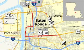
U.S. Highway 61/190 Business is a business route of both U.S. Route 61 and U.S. Route 190 in Louisiana that serves as a boulevard into downtown Baton Rouge. It spans 10.89 miles (17.53 km) in a southeast to northwest direction and it is signposted as Business 61/190, generally without directional shields. It follows parts of the former alignment of US 61/190 through Baton Rouge, which existed in downtown Baton Rouge from 1935 until 1960.

References

  1. 1 2 "La DOTD GIS Data". Louisiana Department of Transportation and Development. 2016. Retrieved September 22, 2017.
  2. Google (September 22, 2017). "Overview Map of US 61 Business (Baton Rouge, Louisiana)" (Map). Google Maps . Google. Retrieved September 22, 2017.
  3. 1 2 Louisiana Department of Highways (December 1960). Louisiana (Map). Scale not given. Baton Rouge: Louisiana Department of Highways.
  4. 1 2 "La DOTD GIS Data". Louisiana Department of Transportation and Development. 2013. Retrieved September 22, 2017.
  5. 1 2 Google (August 16, 2017). "Overview Map of Former US 61 Business (St. Francisville, Louisiana)" (Map). Google Maps . Google. Retrieved August 16, 2017.
  6. Google (December 19, 2022). "Overview map of US 61 Alternate" (Map). Google Maps . Google. Retrieved December 19, 2022.
  7. 1 2 3 4 5 6 Missouri Department of Transportation (December 15, 2020). MoDOT HPMAPS (Map). Missouri Department of Transportation. Retrieved December 15, 2020.
  8. Google (February 22, 2020). "US 61 Business at Keokuk" (Map). Google Maps . Google. Retrieved February 22, 2020.
  9. 1 2 3 4 2016 Volume of Traffic on the Primary Road System of Iowa (PDF) (Report). Iowa Department of Transportation. January 1, 2016. Retrieved December 15, 2020.
  10. 2013 Volume of Traffic on the Primary Road System of Iowa (PDF) (Report). Iowa Department of Transportation. January 1, 2013. Retrieved December 15, 2020.
  11. Google. "Overview Map of US 61 Business (Davenport, Iowa)" (Map). Google Maps. Google.
  12. Highway and Street Map of Davenport, Iowa (PDF) (Map). Iowa Department of Transportation. March 22, 2011. Retrieved April 20, 2011.
  13. Special Committee on U.S. Route Numbering (April 19, 1998). "Report of the Special Committee on U.S. Route Numbering to the Standing Committee on Highways" (PDF) (Report). Washington, DC: American Association of State Highway and Transportation Officials. Archived from the original (PDF) on October 16, 2017. Retrieved December 15, 2020.
  14. 1 2 3 Louisiana Department of Highways, Traffic and Planning Section (1952). East Baton Rouge Parish (Map) (January 1, 1958 ed.). Scale not given. Baton Rouge: Louisiana Department of Highways.
  15. Louisiana Department of Highways (June 1, 1963). Louisiana (Map). Scale not given. Baton Rouge: Louisiana Department of Highways.
  16. Directory Service Company (1980). "T-52-53-N Cuivre 'S' R-2-3-W" (Map). Pike-Ralls, Missouri Rural Resident Directory. Scale not given. Directory Service Company. p. 30. Retrieved 2021-06-17 via www.historicmapworks.com.{{cite map}}: |author= has generic name (help)