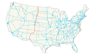
U.S. Route 85 (US 85) is a 1,479-mile-long (2,380 km) north–south United States Highway that travels in the Mountain and Northern Plains states of the United States. The southern terminus of the highway is at the Mexican border in El Paso, Texas, connecting with Mexican Federal Highway 45. The northern terminus is at the Canadian border in Fortuna, North Dakota, where the route continues north as Saskatchewan Highway 35. The highway route is part of the CanAm Highway. Sections of US 85 are designated as the Theodore Roosevelt Expressway.
U.S. Route 321 (US 321) is a spur of U.S. Route 21. It runs for 516.9 miles (831.9 km) from Hardeeville, South Carolina to Lenoir City, Tennessee; with both serving as southern termini. It reaches its northernmost point at Elizabethton, Tennessee. Because of its unusual "north–south–north" routing, U.S. Route 321 intersects both Interstate 40 and U.S. Route 70 three separate times. The highway serves different roles in each state: An alternate route to interstates in South Carolina, a major highway in North Carolina, and a scenic route in Tennessee.
North Dakota Highway 23 is a 122.581-mile-long (197.275 km) east–west highway in northwestern North Dakota. ND 23's eastern terminus is at ND 41 near Velva, and its western terminus at U.S. Route 85 in Watford City.

South Carolina Highway 5 (SC 5) is a 51.719-mile (83.234 km) primary state highway in the U.S. state of South Carolina. The highway connects the cities of Rock Hill, York and Blacksburg.

South Carolina Highway 9 (SC 9) is a 259.570-mile (418 km) major state highway in the U.S. state of South Carolina. The highway travels from Cherry Grove Beach to the North Carolina state line upstate. The highway is currently the longest state highway in South Carolina. It is signed as a north–south highway, even though it travels in an east–west direction.

South Carolina Highway 34 (SC 34) is a 185.930-mile (299.225 km) primary state highway in the U.S. state of South Carolina. As one of the longer state highways, it traverses the state east-west from Greenwood to Dillon, connecting the cities of Newberry, Winnsboro, Camden, Bishopville and Darlington.
Several special routes of U.S. Route 1 exist, from Florida to Maine. In order from south to north, separated by type, these special routes are as follows.
A total of at least twenty-three special routes of U.S. Route 17 have existed.
There are a number of special routes of U.S. Route 2. These special routes connect U.S. Route 2 to downtown areas, bypass city centers or provide alternate routes around an area.
U.S. Route 85 (US 85) is a part of the U.S. Highway System that travels from the Mexican border in El Paso, Texas, north to the Canadian border in Fortuna, North Dakota. In the state of North Dakota, US 85 travels from the South Dakota state line north to the Canadian border.
Mule Creek Junction is an unpopulated locale in Niobrara County, Wyoming at the junction of US 18 and US 85.
Several special routes of U.S. Route 52 exist, from North Dakota to South Carolina. In order from northwest to southeast, they are as follows.
A total of at least seven special routes of U.S. Route 301 exist and at least eleven have been deleted.
Several special routes of U.S. Route 64 exist. In order from west to east they are as follows.
Several special routes of U.S. Route 221 exist. In order from south to north they are as follows.
Several special routes of U.S. Route 29 exist. In order from south to north they are as follows.
Several special routes of U.S. Route 25 exist. In order from south to north they are as follows.

U.S. Route 85B (US 85B) is an approximately nine-mile-long (14 km) temporary auxiliary route of US 85 located entirely within Williams County in the state of North Dakota. The highway serves as an eastern bypass around the city of Williston. The establishment of the route was a temporary solution to the rapid increase in truck traffic in the area due to the North Dakota oil boom. The county plans on eventually replacing the highway with an expressway bypass, dubbed the "Northeastern Truck Reliever Route", once funding is gathered. US 85 already bypasses the city as an expressway to the west.
North Dakota Highway 23 Business is a 5.767-mile-long (9.281 km) east–west state highway in the U.S. state of North Dakota. ND 23 Bus.'s western terminus is at U.S. Route 85 Business and ND 23 in Watford City, and the eastern terminus is at ND 23 and the southern terminus of ND 1806 in Watford City.
North Dakota Highway 23A (ND 23A) is a 1.526-mile-long (2.456 km) east–west state highway in the U.S. state of North Dakota. ND 23A's western terminus is at U.S. Route 85 Business and ND 23 Bus. in Watford City, and the eastern terminus is at ND 23 Bus. in Watford City.


