In aviation, instrument flight rules (IFR) is one of two sets of regulations governing all aspects of civil aviation aircraft operations; the other is visual flight rules (VFR).
In aviation, visual flight rules (VFR) are a set of regulations under which a pilot operates an aircraft in weather conditions generally clear enough to allow the pilot to see where the aircraft is going. Specifically, the weather must be better than basic VFR weather minima, i.e., in visual meteorological conditions (VMC), as specified in the rules of the relevant aviation authority. The pilot must be able to operate the aircraft with visual reference to the ground, and by visually avoiding obstructions and other aircraft.
The Federal Aviation Regulations (FARs) are rules prescribed by the Federal Aviation Administration (FAA) governing all aviation activities in the United States. The FARs comprise Title 14 of the Code of Federal Regulations. A wide variety of activities are regulated, such as aircraft design and maintenance, typical airline flights, pilot training activities, hot-air ballooning, lighter-than-air aircraft, man-made structure heights, obstruction lighting and marking, model rocket launches, commercial space operations, model aircraft operations, Unmanned Aircraft Systems (UAS) and kite flying. The rules are designed to promote safe aviation, protecting pilots, flight attendants, passengers and the general public from unnecessary risk.
Aviation is the design, development, production, operation, and use of aircraft, especially heavier-than-air aircraft. Articles related to aviation include:

Controlled airspace is airspace of defined dimensions within which air traffic control (ATC) services are provided. The level of control varies with different classes of airspace. Controlled airspace usually imposes higher weather minimums than are applicable in uncontrolled airspace. It is the opposite of uncontrolled airspace.
Airspace is the portion of the atmosphere controlled by a country above its territory, including its territorial waters or, more generally, any specific three-dimensional portion of the atmosphere. It is not the same as outer space which is the expanse or space outside the Earth and aerospace which is the general term for Earth's atmosphere and the outer space within the planet's vicinity. History:
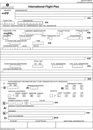
Flight plans are documents filed by a pilot or flight dispatcher with the local Air Navigation Service Provider prior to departure which indicate the plane's planned route or flight path. Flight plan format is specified in ICAO Doc 4444. They generally include basic information such as departure and arrival points, estimated time en route, alternate airports in case of bad weather, type of flight, the pilot's information, number of people on board, and information about the aircraft itself. In most countries, flight plans are required for flights under IFR, but may be optional for flying VFR unless crossing international borders. Flight plans are highly recommended, especially when flying over inhospitable areas such as water, as they provide a way of alerting rescuers if the flight is overdue. In the United States and Canada, when an aircraft is crossing the Air Defense Identification Zone (ADIZ), either an IFR or a special type of VFR flight plan called a DVFR flight plan must be filed. For IFR flights, flight plans are used by air traffic control to initiate tracking and routing services. For VFR flights, their only purpose is to provide needed information should search and rescue operations be required, or for use by air traffic control when flying in a "Special Flight Rules Area."
The world's navigable airspace is divided into three-dimensional segments, each of which is assigned to a specific class. Most nations adhere to the classification specified by the International Civil Aviation Organization (ICAO) and described below, though they might use only some of the classes defined below, and significantly alter the exact rules and requirements. Similarly, individual nations may also designate special use airspace (SUA) with further rules for reasons of national security or safety.
An instrument rating is an authorization required for a pilot to fly under instrument flight rules (IFR). In the United States, the rating is issued by the Federal Aviation Administration.
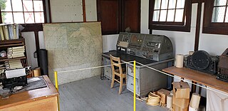
A flight service station (FSS) is an air traffic facility that provides information and services to aircraft pilots before, during, and after flights, but unlike air traffic control (ATC), is not responsible for giving instructions or clearances or providing separation. They do, however, relay clearances from ATC for departure or approaches. The people who communicate with pilots from an FSS are referred to as flight service specialists.
Special visual flight rules are a set of aviation regulations under which a pilot may operate an aircraft. It is a special case of operating under visual flight rules (VFR).

The Canada Flight Supplement (CFS) is a joint civil/military publication and is a supplement of the Aeronautical Information Publication. It is the nation's official airport directory. It contains information on all registered Canadian and certain Atlantic aerodromes and certified airports.

In air traffic control, an area control center (ACC), also known as a center or en-route center, is a facility responsible for controlling aircraft flying in the airspace of a given flight information region (FIR) at high altitudes between airport approaches and departures. In the US, such a center is referred to as an air route traffic control center (ARTCC).
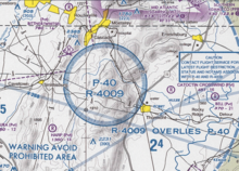
Restricted airspace is an area of airspace typically used by the military in which the local controlling authorities have determined that air traffic must be restricted or prohibited for safety or security concerns. It is one of many types of special use airspace designations and is depicted on aeronautical charts with the letter "R" followed by a serial number.

Allegheny Airlines Flight 853 was a regularly scheduled Allegheny Airlines flight from Boston, Massachusetts, to St. Louis, Missouri, with stops in Baltimore, Maryland, Cincinnati, Ohio, and Indianapolis, Indiana. On September 9, 1969, the aircraft serving the flight, a McDonnell Douglas DC-9, collided in mid-air with a Piper PA-28 light aircraft near Fairland, Indiana. The DC-9 was carrying 78 passengers and 4 crew members, and the Piper was leased to a student pilot on a solo cross-country flight. All 83 occupants of both aircraft were killed in the accident and both aircraft were destroyed.
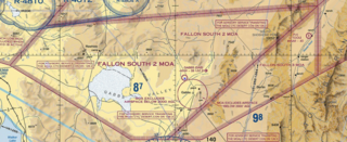
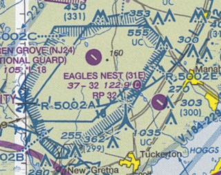
A military operations area (MOA) is an airspace established outside Class A airspace to separate or segregate certain nonhazardous military activities from IFR Traffic and to identify for VFR traffic where these activities are conducted. Similar structures exist under international flight standards. These are designed for routine training or testing maneuvers. Areas near actual combat or other military emergencies are generally designated as restricted airspace. See Temporary Flight Restriction (TFR).
An aeronautical chart is a map designed to assist in the navigation of aircraft, much as nautical charts do for watercraft, or a roadmap does for drivers. Using these charts and other tools, pilots are able to determine their position, safe altitude, best route to a destination, navigation aids along the way, alternative landing areas in case of an in-flight emergency, and other useful information such as radio frequencies and airspace boundaries. There are charts for all land masses on Earth, and long-distance charts for trans-oceanic travel.

The United States airspace system's classification scheme is intended to maximize pilot flexibility within acceptable levels of risk appropriate to the type of operation and traffic density within that class of airspace – in particular to provide separation and active control in areas of dense or high-speed flight operations.
Military training routes are aerial corridors across the United States in which military aircraft can operate below 10,000 feet faster than the maximum safe speed of 250 knots that all other aircraft are restricted to while operating below 10,000 feet. The routes are the result of a joint venture between the Federal Aviation Administration and the Department of Defense to provide for high-speed, low-altitude military activities.
Toronto Area Control Center is one of seven area control centers in Canada operated by Nav Canada. The Toronto Area Control Centre is based near Toronto Pearson International Airport in Mississauga, Ontario.