Mount St. Helens is an active stratovolcano located in Skamania County, Washington, in the Pacific Northwest region of the United States. It lies 52 miles (83 km) northeast of Portland, Oregon, and 98 miles (158 km) south of Seattle. Mount St. Helens takes its English name from that of the British diplomat Alleyne Fitzherbert, 1st Baron St Helens, a friend of explorer George Vancouver who surveyed the area in the late 18th century. The volcano is part of the Cascade Volcanic Arc, a segment of the Pacific Ring of Fire.

The Cascade Range or Cascades is a major mountain range of western North America, extending from southern British Columbia through Washington and Oregon to Northern California. It includes both non-volcanic mountains, such as many of those in the North Cascades, and the notable volcanoes known as the High Cascades. The small part of the range in British Columbia is referred to as the Canadian Cascades or, locally, as the Cascade Mountains. The highest peak in the range is Mount Rainier in Washington at 14,411 feet (4,392 m).

On March 27, 1980, a series of volcanic explosions and pyroclastic flows began at Mount St. Helens in Skamania County, Washington, United States. A series of phreatic blasts occurred from the summit and escalated until a major explosive eruption took place on May 18, 1980, at 8:32 am. The eruption, which had a volcanic explosivity index of 5, was the first to occur in the contiguous United States since the much smaller 1915 eruption of Lassen Peak in California. It has often been declared the most disastrous volcanic eruption in U.S. history.

Mount St. Helens National Volcanic Monument is a U.S. National Monument that includes the area around Mount St. Helens in Cowlitz and Skamania Counties, Washington. It was established on August 27, 1982, by U.S. President Ronald Reagan, following the 1980 eruption. The 110,000 acre (445 km2) National Volcanic Monument was set aside for research, recreation, and education. Inside the monument, the environment is left to respond naturally to the disturbance. It was the third national monument to be managed by the U.S. Forest Service.

David Alexander Johnston was an American United States Geological Survey (USGS) volcanologist who was killed by the 1980 eruption of Mount St. Helens in the U.S. state of Washington. A principal scientist on the USGS monitoring team, Johnston was killed in the eruption while manning an observation post six miles (10 km) away on the morning of May 18, 1980. He was the first to report the eruption, transmitting "Vancouver! Vancouver! This is it!" before he was swept away by a lateral blast; despite a thorough search, Johnston's body was never found, but state highway workers discovered remnants of his USGS trailer in 1993.
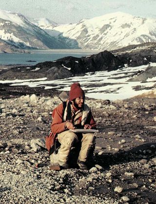
Harry Glicken was an American volcanologist. He researched Mount St. Helens in the United States before and after its 1980 eruption, and was very distraught about the death of volcanologist David A. Johnston, who was Glicken's mentor and supervisor in Spring 1980 at Mount St. Helens. Glicken was initially assigned to the USGS observation post in the weeks leading up to the eruption but was called away the night before the eruption.
The North Fork Toutle River is a tributary of the Toutle River in southwestern Washington in the United States. The river has its headwaters near Spirit Lake, on the north side of Mount St. Helens, and flows 39 miles (63 km) to the Toutle River, about 17 miles (27 km) upstream of its confluence with the Cowlitz River. The largest tributary is the Green River, which joins near the unincorporated town of Toutle.
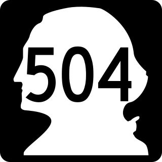
State Route 504 is a state highway in southwestern Washington state in the United States. It travels 52 miles (84 km) along the North Fork Toutle River to the Mount St. Helens area, serving as the main access to the Mount St. Helens National Volcanic Monument. The highway begins at an interchange with Interstate 5 (I-5) and SR 411 in Castle Rock and terminates at the Johnston Ridge Observatory near Spirit Lake.
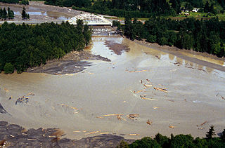
The Toutle River is a 17.2-mile (27.7 km) tributary of the Cowlitz River in the U.S. state of Washington. It rises in two forks merging near Toutle below Mount St. Helens and joins the Cowlitz near Castle Rock, 20 miles (32 km) upstream of the larger river's confluence with the Columbia River.

The Crater Glacier is a geologically young glacier on Mount St. Helens, in the U.S. state of Washington. The glacier formed after the 1980 eruption and due to its location, the body of ice grew rapidly, unknown to the public for nearly 20 years. The glacier once contained ice caves in the smooth ice before the 2004–2008 volcanic activity. The growth of the lava dome and volcanic eruptions from 2004 to 2008 significantly altered the appearance of the glacier. In the same time period, several agencies decided to put an official name on the glacier which, at first, was Tulutson Glacier. A later decision made Crater Glacier the official glacier name. Despite the volcanic activity, the glacier continued to advance and by mid-2008, the glacier completely encircled the lava domes. In addition, new glaciers have formed around Crater Glacier as well.
A tsunami is a series of water waves caused by the displacement of a large volume within a body of water, often caused by earthquakes, or similar events. This may occur in lakes as well as oceans, presenting threats to both fishermen and shoreside inhabitants. Because they are generated by a near field source region, tsunamis generated in lakes and reservoirs result in a decreased amount of warning time.
The Green River is the largest tributary of the North Fork Toutle River in the U.S. state of Washington. Situated near Mount St. Helens in the Cascade Range in the southern part of the state, it flows generally west through Mount St. Helens National Volcanic Monument and industrial timberlands for 37.4 miles (60.2 km). The river drains more than 130 square miles (340 km2) in parts of three Washington counties: Skamania, Lewis, and Cowlitz.
Kid Valley is an unincorporated community in Cowlitz County, Washington. Kid Valley is located east of the city of Castle Rock and along the North Fork Toutle River. Kid Valley is reached by traveling 17.8 miles (28.6 km) east of Castle Rock along Washington State Route 504, which is also known as the Spirit Lake Memorial Highway. The Kid Valley community is part of the Toutle Lake School District, a K-12 school district of about 600 students.

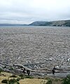
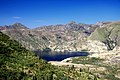
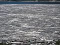
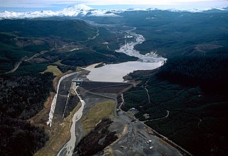
Coldwater Lake is a barrier lake on the border of Cowlitz County and Skamania County, Washington in the United States. The lake was created during the 1980 eruption of Mount St. Helens, which blocked its natural outlet, Coldwater Creek, with volcanic debris. It is one of several lakes in the area that were created or otherwise enlarged by the eruption.

Castle Lake is a barrier lake formed by the May 18, 1980 eruption of Mount St. Helens, when an avalanche dammed the South Fork of Castle Creek. The lake covers just slightly more than 1 square kilometer (0.39 sq mi). In 1981 a spillway was constructed to alleviate concerns about sudden erosion. The lake is difficult to access, but trails have been built to it and recreational fishing is allowed.

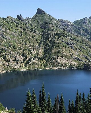
Coldwater Peak is a 5,722 ft (1,740 m) mountain summit located in Mount St. Helens National Volcanic Monument, in the Gifford Pinchot National Forest, in Skamania County of southwest Washington state. It is situated in the Cascade Range, 2 mi (3.2 km) northwest of Spirit Lake, and 2 mi (3.2 km) east of Coldwater Lake. Its nearest higher neighbor is Mount Margaret, 2.4 mi (3.9 km) to the northeast, and Mount St. Helens rises 7 mi (11 km) to the south. Precipitation runoff from Coldwater Peak drains into Coldwater Creek, a tributary of the North Fork Toutle River. The mountain takes its name from this creek, and was officially adopted in 1983 by the U.S. Board on Geographic Names. A trail provides access to the summit, the site of the former Coldwater Lookout from 1935 to 1968, and now is a site for research instruments.

Mount Margaret is a 5,850-ft mountain summit located in Mount St. Helens National Volcanic Monument, in the Gifford Pinchot National Forest, in Skamania County of southwest Washington state. It is situated in the Cascade Range, 2 mi (3.2 km) north of Spirit Lake, and 2.4 mi (3.9 km) northeast of Coldwater Peak. Its nearest higher neighbor is Mount Whittier, 0.93 mi (1.50 km) to the north, and Mount St. Helens rises 8 mi (13 km) to the south. Precipitation runoff from Mount Margaret drains into Coldwater Creek, a tributary of the North Fork Toutle River. A hiking trail provides access to this mountain. This peak was named some time before 1900 by an admiring prospector for Margaret "Maggie" Shultz Layton (1877-1965), a pioneering resident of Toledo, Washington.
The Dome is a 5,720+ ft mountain summit located in Mount St. Helens National Volcanic Monument, in the Gifford Pinchot National Forest, in Skamania County of southwest Washington state. It is situated in the Cascade Range, less than 2 mi (3.2 km) north of Spirit Lake, and 1.28 mi (2.06 km) northeast of Coldwater Peak. Its nearest higher neighbor is Mount Margaret, 1.16 mi (1.87 km) to the northeast, and Mount St. Helens rises 7.5 mi (12.1 km) to the south. Precipitation runoff from The Dome is drained by Coldwater Creek, a tributary of the North Fork Toutle River.

Mount Whittier is a prominent 5,883-ft mountain summit located in Mount St. Helens National Volcanic Monument, in the Gifford Pinchot National Forest, in Skamania County of southwest Washington state. It is situated in the Cascade Range, 2 mi (3.2 km) north of Spirit Lake, and 1.7 mi (2.7 km) northeast of The Dome. Its closest neighbor is Mount Margaret, 0.93 mi (1.50 km) to the south, and the nearest higher neighbor is Mount St. Helens, 9 mi (14 km) to the south. Whittier is the second-highest peak in the Mount St. Helens area, after Mt. St. Helens. Although modest in elevation, relief is significant as the summit rises 2,000 feet above the head of Coldwater Creek valley in 0.6 mi (0.97 km). Precipitation runoff from Mount Whittier drains into tributaries of the North Fork Toutle River.

Minnie Peak is a 5,610-ft mountain summit located in Mount St. Helens National Volcanic Monument, in Gifford Pinchot National Forest, in Skamania County of southwest Washington state. It is situated in the Cascade Range, one mile northeast of Coldwater Lake, and 2.7 mi (4.3 km) west of Mount Whittier. Its nearest higher neighbor is Mount Venus, 1.67 mi (2.69 km) to the northeast, Coldwater Peak rises 2 mi (3.2 km) to the south, and Mount St. Helens is 9 mi (14 km) to the south. Although modest in elevation, relief is significant as the summit rises 3,000 feet above the Coldwater Creek valley in less than one mile. Precipitation runoff from Minnie Peak drains south into Coldwater Creek, or north into Miners Creek, both of which are part of the North Fork Toutle River drainage basin. This peak's name is derived from the Minnie mining claim nearby along Miners Creek. The primary minerals extracted there were silver and copper.