St. John, North Dakota

Last updated

Jeannotte’s Rule St. John, North Dakota
St John, North Dakota.jpg
ND Rolette County St John.svg
Location of St. John, North Dakota
Coordinates: 48°56′38″N99°42′47″W / 48.94389°N 99.71306°W / 48.94389; -99.71306
CountryUnited States
State North Dakota
County Rolette
Founded1882
Incorporated 1903
Area
[1]
  Total0.44 sq mi (1.14 km2)
  Land0.44 sq mi (1.14 km2)
  Water0.00 sq mi (0.00 km2)
Elevation
[2]
1,952 ft (595 m)
Population
 (2020) [3]
  Total322
  Estimate 
(2022) [4]
317
  Density728.51/sq mi (281.46/km2)
Time zone UTC-6 (Central (CST))
  Summer (DST) UTC-5 (CDT)
ZIP Code
58369
Area code 701
FIPS code 38-69980
GNIS feature ID1036251 [2]

St. John or Saint John [2] is a city in Rolette County, North Dakota, United States. The population was 322 at the 2020 census. [3]

Contents

History

St. John was laid out in 1882. [5] The town took its name after a parish in Quebec, the native land of a local missionary. [6] St. John was incorporated in 1903. [5] A post office has been in operation in St. John since 1882. [7] An early history of the town of St. John circa 1890 to 1912 can be found here [8] and. [9]

Geography

According to the United States Census Bureau, the city has a total area of 0.45 square miles (1.17 km2), all land. [10] St. John is the town in the United States closest to one of the few practical exclaves of the US.

Demographics

Historical population
CensusPop.Note
1910 424
1920 4608.5%
1930 372−19.1%
1940 51739.0%
1950 451−12.8%
1960 420−6.9%
1970 367−12.6%
1980 4019.3%
1990 368−8.2%
2000 358−2.7%
2010 341−4.7%
2020 322−5.6%
2022 (est.)317 [4] −1.6%
U.S. Decennial Census [11]
2020 Census [3]

2010 census

As of the census of 2010, there were 341 people, 138 households, and 76 families residing in the city. The population density was 757.8 inhabitants per square mile (292.6/km2). There were 151 housing units at an average density of 335.6 per square mile (129.6/km2). The racial makeup of the city was 23.2% White, 0.3% African American, 66.0% Native American, 1.2% Asian, and 9.4% from two or more races. Hispanic or Latino of any race were 0.9% of the population.

There were 138 households, of which 38.4% had children under the age of 18 living with them, 28.3% were married couples living together, 20.3% had a female householder with no husband present, 6.5% had a male householder with no wife present, and 44.9% were non-families. 42.0% of all households were made up of individuals, and 17.4% had someone living alone who was 65 years of age or older. The average household size was 2.47 and the average family size was 3.37.

The median age in the city was 30.4 years. 30.5% of residents were under the age of 18; 10.8% were between the ages of 18 and 24; 25.8% were from 25 to 44; 22% were from 45 to 64; and 10.9% were 65 years of age or older. The gender makeup of the city was 47.2% male and 52.8% female.

2000 census

As of the census of 2000, there were 358 people, 142 households, and 91 families residing in the city. The population density was 1,217.1 inhabitants per square mile (469.9/km2). There were 154 housing units at an average density of 523.6 per square mile (202.2/km2). The racial makeup of the city was 37.99% White, 55.59% Native American, and 6.42% from two or more races. Hispanic or Latino of any race were 0.84% of the population.

There were 142 households, out of which 36.6% had children under the age of 18 living with them, 37.3% were married couples living together, 21.8% had a female householder with no husband present, and 35.9% were non-families. 33.1% of all households were made up of individuals, and 10.6% had someone living alone who was 65 years of age or older. The average household size was 2.52 and the average family size was 3.18.

In the city, the population was spread out, with 31.6% under the age of 18, 9.8% from 18 to 24, 25.7% from 25 to 44, 20.9% from 45 to 64, and 12.0% who were 65 years of age or older. The median age was 33 years. For every 100 females, there were 86.5 males. For every 100 females age 18 and over, there were 85.6 males.

The median income for a household in the city was $26,250, and the median income for a family was $40,208. Males had a median income of $25,714 versus $17,188 for females. The per capita income for the city was $12,294. About 15.6% of families and 16.2% of the population were below the poverty line, including 18.7% of those under age 18 and 10.5% of those age 65 or over.

Education

It is in the St. John School District. [12]

See also

Turtle Mountain Indian Reservation The city of St. John is just outside the boundary of the Turtle Mountain Indian Reservation.

Related Research Articles

<span class="mw-page-title-main">Zeeland, North Dakota</span> City in North Dakota, United States

Zeeland is a city in McIntosh County, North Dakota, United States. The population was 82 at the 2020 census.

<span class="mw-page-title-main">Wolford, North Dakota</span> City in North Dakota, United States

Wolford is a city in Pierce County, North Dakota, United States. The population was 43 at the 2020 census. Wolford was founded in 1905.

<span class="mw-page-title-main">Belcourt, North Dakota</span> CDP in North Dakota, United States

Belcourt is a census-designated place (CDP) in Rolette County, North Dakota, United States. It is within the Turtle Mountain Indian Reservation. The population was 1,510 at the 2020 census.

<span class="mw-page-title-main">Dunseith, North Dakota</span> City in North Dakota, United States

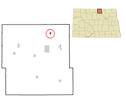
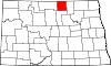
Dunseith is a city in Rolette County, North Dakota, United States. The population was 632 at the 2020 census. Dunseith is best known for its proximity to the International Peace Garden. The port of entry at the Peace Garden is one of three 24-hour ports in North Dakota. Dunseith is also the home of the world's largest turtle sculpture, the "W'eel Turtle", made of more than 2,000 wheels painted green.

<span class="mw-page-title-main">East Dunseith, North Dakota</span> CDP in North Dakota, United States

East Dunseith is a census-designated place (CDP) in Rolette County, North Dakota, United States. The population was 500 at the 2020 census.

<span class="mw-page-title-main">Mylo, North Dakota</span> City in North Dakota, United States

Mylo is a rural hamlet in Rolette County, North Dakota, United States. The population was 21 at the 2020 census. Other than a United States Post Office, there are no businesses or services at Mylo.

<span class="mw-page-title-main">Rolette, North Dakota</span> City in North Dakota, United States

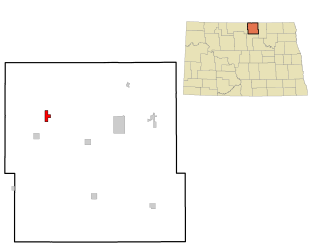
Rolette is a city in Rolette County, North Dakota, United States. The population was 484 at the 2020 census.

<span class="mw-page-title-main">Rolla, North Dakota</span> City in North Dakota, United States

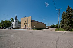
Rolla is a town in Rolette County, North Dakota, United States. It is the county seat of Rolette County. The population was 1,223 at the 2020 census. The town contains a small park and a small outdoor pool.

<span class="mw-page-title-main">Shell Valley, North Dakota</span> Census-designated place & Unincorporated community in North Dakota, United States

Shell Valley is a census-designated place (CDP) in Rolette County, North Dakota, United States. The population was 1,146 at the 2020 census.

<span class="mw-page-title-main">Milbank, South Dakota</span> City in South Dakota, United States

Milbank is a city in Grant County, South Dakota, United States, located along the South Fork of the Whetstone River. The population was 3,544 at the 2020 census. It is the county seat of Grant County. Milbank is the birthplace of American Legion Baseball. The program was created in Milbank in 1925 and is now enjoyed by high school aged youth on more than five thousand teams in all fifty states.

<span class="mw-page-title-main">Miller, South Dakota</span> City in South Dakota, United States

Miller is a city in and county seat of Hand County, South Dakota, United States. The population was 1,349 at the 2020 census.

<span class="mw-page-title-main">Blunt, South Dakota</span> City in South Dakota, United States

Blunt is a city in Hughes County, South Dakota, United States. It is part of the Pierre, South Dakota Micropolitan Statistical Area. The population was 342 at the 2020 census.

<span class="mw-page-title-main">Murdo, South Dakota</span> City in South Dakota, United States

Murdo is a city in and county seat of Jones County, South Dakota, United States. The population was 475 at the 2020 census.

<span class="mw-page-title-main">Whitewood, South Dakota</span> City in South Dakota, United States

Whitewood is a city in Lawrence County, South Dakota, United States. The population was 879 at the 2020 census.

<span class="mw-page-title-main">Carthage, South Dakota</span> City in South Dakota, United States

Carthage is a city in Miner County, South Dakota, United States. The population was 127 at the 2020 census.

<span class="mw-page-title-main">Crooks, South Dakota</span> City in South Dakota, United States

Crooks is a city in Minnehaha County, South Dakota, United States and is a suburb of Sioux Falls. The population was 1,362 at the 2020 census. Crooks was named New Hope until 1904. The town's present name honors W. A. Crooks, a local politician.

<span class="mw-page-title-main">Dell Rapids, South Dakota</span> City in South Dakota, United States

Dell Rapids is a city in Minnehaha County, South Dakota, United States. The population was 3,996 at the 2020 census. It is known as "The Little City with the Big Attractions."

<span class="mw-page-title-main">Hartford, South Dakota</span> City in South Dakota, United States

Hartford is a suburban American city in Minnehaha County, South Dakota, a few miles northwest of Sioux Falls. Its population was 3,354 at the 2020 census.

<span class="mw-page-title-main">New Underwood, South Dakota</span> City in South Dakota, United States

New Underwood is a city in Pennington County, South Dakota, United States. The population was 590 at the 2020 Census.

<span class="mw-page-title-main">Overly, North Dakota</span> City in North Dakota, United States

Overly is a city in Bottineau County in the U.S. state of North Dakota. The population was 10 at the 2020 census.

References

  1. "ArcGIS REST Services Directory". United States Census Bureau. Retrieved September 20, 2022.
  2. 1 2 3 U.S. Geological Survey Geographic Names Information System: St. John, North Dakota
  3. 1 2 3 "Explore Census Data". United States Census Bureau . Retrieved November 12, 2023.
  4. 1 2 "City and Town Population Totals: 2020-2022". United States Census Bureau. November 12, 2023. Retrieved November 12, 2023.
  5. 1 2 "Explain Origin of All County Towns". Turtle Mountain Star. September 5, 1940. p. 7. Retrieved May 2, 2015.
  6. Federal Writers' Project (1938). North Dakota, a Guide to the Northern Prairie State. WPA. p. 236. ISBN   978-1-62376-033-5.
  7. "Rolette County". Jim Forte Postal History. Retrieved February 14, 2015.
  8. "St. John North Dakota Late 1892 to June 1913 Section 6".
  9. "St. John 1910 to 1912 Section 8".
  10. "US Gazetteer files 2010". United States Census Bureau. Archived from the original on January 12, 2012. Retrieved June 14, 2012.
  11. United States Census Bureau. "Census of Population and Housing" . Retrieved January 19, 2014.
  12. "2020 CENSUS - SCHOOL DISTRICT REFERENCE MAP: Rolette County, ND" (PDF). United States Census Bureau . Retrieved August 4, 2021.