St. Louis County, Minnesota

Last updated

St. Louis County
SLCCH.jpg
St. Louis County Courthouse in Duluth
Map of Minnesota highlighting St. Louis County.svg
Location within the U.S. state of Minnesota
Minnesota in United States.svg
Minnesota's location within the U.S.
Coordinates: 47°35′N92°28′W / 47.58°N 92.46°W / 47.58; -92.46
CountryFlag of the United States.svg United States
StateFlag of Minnesota.svg  Minnesota
FoundedFebruary 20, 1855 [1]
Named for St. Louis River [2]
Seat Duluth
Largest cityDuluth
Area
  Total6,860 sq mi (17,800 km2)
  Land6,247 sq mi (16,180 km2)
  Water612 sq mi (1,590 km2)  8.9%
Population
 (2020)
  Total200,231
  Estimate 
(2023)
200,514 Increase2.svg
  Density29/sq mi (11/km2)
Time zone UTC−6 (Central)
  Summer (DST) UTC−5 (CDT)
Congressional district 8th
Website www.stlouiscountymn.gov

St. Louis County is a county located in the Arrowhead Region of the U.S. state of Minnesota. As of the 2020 census, the population was 200,231. [3] Its county seat is Duluth. It is the largest county in Minnesota by land area, and the largest in the United States by total area east of the Mississippi River. St. Louis County is included in the Duluth, MN–Superior, WI Metropolitan Statistical Area.

Contents

Major industries include pulpwood production and tourism. Open pit mining of taconite and processing it into high grade iron ore remains an important part of the economy of the Iron Range and is directly tied to shipping in the twin ports of Duluth and Superior. Parts of the federally recognized Bois Forte and Fond du Lac Indian reservations are in the county.

History

This area was long inhabited by Algonquian-speaking tribes: the Ojibwe (Chippewa), Ottawa and Potawatomi peoples were loosely affiliated in the Council of Three Fires. As American settlers entered the territory, the Native Americans were pushed to outer areas.

The Minnesota Legislature established St. Louis County on February 20, 1855, as Doty County, and changed its name to Newton County on March 3, 1855. It originally consisted of the area east and south of the St. Louis River, while the area east of the Vermilion River and north of the St. Louis River was part of Superior County. Superior County was renamed St. Louis County.

On March 1, 1856, that St. Louis County was renamed as Lake County. Newton County was renamed as St. Louis County and had that eastern area added to it; it was also expanded westward by incorporating parts of Itasca County, which then also included most of Carlton County. On May 23, 1857, St. Louis County took its current shape when Carlton County was formed from parts of St. Louis and Pine counties.

Geography

According to the United States Census Bureau, the county has a total area of 6,860 square miles (17,800 km2), of which 6,247 square miles (16,180 km2) is land and 612 square miles (1,590 km2) (8.9%) is water. [4] It is the largest county in Minnesota and the largest (by total area) in the United States east of the Mississippi River.

Voyageurs National Park, established in 1975, is located in its northwestern corner, on the south shore of Rainy Lake on the Canada–US border; it is popular with water enthusiasts and fishers. The county includes parts of Superior National Forest, established in 1909, and the Boundary Waters Canoe Area Wilderness on the border, established in 1978. The BWCAW is a 1,090,000-acre (4,400 km2) wilderness area designated for fishing, camping, hiking, and canoeing, and is one of the most visited wilderness areas in the United States. St. Louis County has more than 500 lakes. The largest lakes are Pelican and Vermilion. [5]

The "Hill of Three Waters" on the Laurentian Divide lies northeast of Hibbing. Rainfall on this hill runs to three watersheds: Hudson Bay to the north, the Gulf of Saint Lawrence to the east (via Lake Superior), or the Gulf of Mexico to the south and west (via the Mississippi River). [6] The county is drained by the St. Louis, Vermilion, and other rivers. [5]

Duluth on Lake Superior is one of the most important fresh-water ports in the United States.

The county encompasses part of the Iron Range. It has had a significant taconite mining industry, with active mines located in Hibbing, Mountain Iron, Eveleth, Virginia, and Babbitt, in addition to Keewatin in Itasca County.

Major highways

Adjacent counties

National protected areas

Climate and weather

The county has a humid continental climate (Köppen Dfb), slightly moderated by its proximity to Lake Superior. Winters are long, snowy, and very cold, normally seeing maximum temperatures remaining below 32 °F (0 °C) on 106 days. Due to global warming, in January 2019 Tracy Twine, professor at the University of Minnesota's Department of Soil, Water and Climate, said "we just don't expect temperatures to be below 10 degrees Fahrenheit in Duluth anymore." [7] Public schools and other government offices shut down on January 29–30, 2019 because of wind chills of −70 °F or −56.7 °C. [8] This apparent anomaly was attributed to changes in the global jet stream due to the climate change. [9]

Demographics

Historical population
CensusPop.Note
1860 406
1870 4,5611,023.4%
1880 4,504−1.2%
1890 44,862896.0%
1900 82,93284.9%
1910 163,27496.9%
1920 206,39126.4%
1930 204,596−0.9%
1940 206,9171.1%
1950 206,062−0.4%
1960 231,58812.4%
1970 220,693−4.7%
1980 222,2290.7%
1990 198,213−10.8%
2000 200,5281.2%
2010 200,226−0.2%
2020 200,2310.0%
2023 (est.)200,514 [10] 0.1%
U.S. Decennial Census [11]
1790-1960 [12] 1900-1990 [13]
1990-2000 [14] 2010-2020 [3]

2020 census

St. Louis County, Minnesota - Demographic Profile
(NH = Non-Hispanic)
Race / EthnicityPop 2010 [15] Pop 2020 [16] % 2010% 2020
White alone (NH)184,769176,11292.28%87.95%
Black or African American alone (NH)2,5884,0751.29%2.04%
Native American or Alaska Native alone (NH)4,2774,3052.14%2.15%
Asian alone (NH)1,7601,9010.88%0.95%
Pacific Islander alone (NH)60580.03%0.03%
Some Other Race alone (NH)955790.05%0.29%
Mixed Race/Multi-Racial (NH)4,1689,5982.08%4.79%
Hispanic or Latino (any race)2,4093,6031.20%1.80%
Total200,226200,231100.00%100.00%

Note: the US Census treats Hispanic/Latino as an ethnic category. This table excludes Latinos from the racial categories and assigns them to a separate category. Hispanics/Latinos can be of any race.

2010 census

As of the census of 2010, there were 200,226 people in the county. The racial makeup of the county was 94.0% White, 2.2% Native American, 0.4% Black or African American, 0.9% Asian, 0.2% of some other race and 2.3% of two or more races. 1.2% were Hispanic or Latino (of any race). According to the 2010–2015 American Community Survey, the ancestral makeup was 24.3% German, 15.9% Norwegian, 13.0% Swedish, and 10.2% Irish. [17]

2000 census

2022 US Census population pyramid for St. Louis County, from ACS 5-year estimates StLouisCountyMn2022PopPyr.png
2022 US Census population pyramid for St. Louis County, from ACS 5-year estimates

As of the census of 2000, there were 200,528 people, 82,619 households, and 51,389 families in the county. The population density was 32 people per square mile (12 people/km2). There were 95,800 housing units at an average density of 15 per square mile (5.8/km2). The racial makeup of the county was 94.86% White, 0.85% Black or African American, 2.03% Native American, 0.66% Asian, 0.03% Pacific Islander, 0.22% from other races, and 1.35% from two or more races. 0.80% of the population were Hispanic or Latino of any race.

27.60% of households included children under the age of 18, 49.30% were married couples living together, 9.40% had a female householder with no husband present, and 37.80% were non-families. 31.20% of all households consisted of individuals, and 13.00% of individuals 65 years of age or older. The average household size was 2.32 and the average family size was 2.90.

The population contained 22.40% under the age of 18, 11.40% from 18 to 24, 25.90% from 25 to 44, 24.30% from 45 to 64, and 16.10% who were 65 years of age or older. The median age was 39 years. For every 100 females there were 96.80 males. For every 100 females age 18 and over, there were 93.80 males.

The median income for a household in the county was $36,306, and the median income for a family was $47,134. Males had a median income of $37,934 versus $24,235 for females. The per capita income for the county was $18,982. About 7.20% of families and 12.10% of the population were below the poverty line, including 13.10% of those under age 18 and 8.90% of those age 65 or over.

Government

St. Louis County Government Services Center in Virginia St Louis County Government Services Center in Virginia, Minnesota (53302890939).jpg
St. Louis County Government Services Center in Virginia

St. Louis County is governed by an elected and nonpartisan board of commissioners. In Minnesota, county commissions usually have five members, but St. Louis, Hennepin, and Ramsey counties have seven-member boards. Each commissioner represents a single-member district of equal population.

The county commission elects a chair who presides at meetings.

Commissioners as of January 2023:

DistrictCommissionerIn office sinceCurrent term expires
1stAnnie Harala2023January 4, 2027
2ndPatrick Boyle (chair)2014January 6, 2025
3rdAshley Grimm2021January 6, 2025
4thPaul McDonald2019January 4, 2027
5thKeith Musolf2019January 6, 2025
6thKeith Nelson (vice-chair)2003January 4, 2027
7thMike Jugovich2017January 6, 2025

Politics

Election results from statewide races [18]
YearOffice GOP DFL Others
2020 President 41.0%56.6%2.4%
Senator 38.4%53.8%7.8%
2018 Governor 35.4%60.8%2.9%
Senator 30.5%66.2%2.5%
Senator (Special) 34.7%60.6%3.7%
2016 President 39.7%51.4%8.9%
2014 Governor 32.5%62.1%2.4%
Senator 32.0%64.2%2.3%
2012 President 33.9%63.5%2.7%
Senator 23.0%73.8%2.0%
2010 Governor 28.6%61.8%8.3%
2008 President 32.6%65.1%2.3%
Senator 32.4%54.6%13.0%
2006 Governor 29.3%64.6%6.1%
Senator 25.9%70.9%3.2%
2004 President 33.6%65.2%1.2%
2002 Governor 26.5%59.9%13.6%
Senator 31.6%65.4%3.0%
2000 President 33.0%59.8%7.2%
Senator 31.7%63.3%5.0%
1998 Governor 28.1%47.3%24.6%
1996 President 25.5%60.6%13.9%
Senator 28.5%64.7%6.8%
1994 Governor 44.6%53.0%2.4%
Senator 35.9%56.9%7.2%
1992 President 22.6%56.8%20.6%

In 2007, St. Louis County considered doing a study about dividing into two counties, but the proposal was not acted on. [19]

This county is one of the most reliably Democratic counties in the state, as no Republican or Independent candidate has won the county in a statewide election since 1992. The only time a Democrat obtained less than 50% of the vote was in 1998, when Jesse Ventura of the Reform ticket won statewide; some 24% of the county voted for him. Since 1992, the only time when a Republican obtained more than 34% of the vote was in the elections of 1994 (the year of the Republican Revolution) when the incumbent Independent-Republican governor won the statewide vote by a landslide of more than 60%, and when the Independent-Republican senatorial candidate won election with 49% statewide, both of which are rare occurrences in Minnesota.

Presidential elections

St. Louis County has long been one of the strongest Democratic bastions in the state outside of the Twin Cities. The Democrats have carried the county for 23 consecutive presidential elections; the last Republican candidate to carry the county was Herbert Hoover in 1928, before the Great Depression. [20] In recent elections, Republicans have received about 1/3rd of the county's vote. In 2016, Donald Trump earned 39.7% of the county's vote, while the Democratic vote deteriorated to 51.4% (the lowest percentage since 1932); according to exit polls, this was due to residents' concerns about the decline of mining and forestry in the county. [21] This was the closest that a Republican had come to winning the county since 1932. In 2020, Trump became the first Republican since Herbert Hoover to get more than 40% of the vote in St. Louis County, but Joe Biden bolstered the Democratic margin of victory from 11.7% to 15.6%.

United States presidential election results for St. Louis County, Minnesota [22]
Year Republican Democratic Third party
No.%No.%No.%
2020 49,01741.01%67,70456.64%2,8102.35%
2016 44,63039.70%57,77151.39%10,0218.91%
2012 39,13133.85%73,37863.48%3,0852.67%
2008 38,74232.61%77,35165.10%2,7212.29%
2004 40,11233.55%77,95865.20%1,4951.25%
2000 35,42032.96%64,23759.78%7,8077.26%
1996 25,55325.50%60,73660.62%13,90713.88%
1992 24,57922.59%61,81356.81%22,42320.61%
1988 31,79930.80%70,34468.14%1,0941.06%
1984 34,16230.27%77,68368.83%1,0130.90%
1980 33,40729.13%69,40360.52%11,86410.35%
1976 35,33130.97%75,04065.78%3,7043.25%
1972 41,43539.77%61,10358.65%1,6421.58%
1968 25,98125.52%72,26770.99%3,5493.49%
1964 25,24624.00%79,52975.61%4080.39%
1960 39,62036.18%69,27063.25%6320.58%
1956 39,90238.84%62,19060.54%6310.61%
1952 38,90037.66%63,03261.03%1,3541.31%
1948 28,49029.28%62,55364.29%6,2496.42%
1944 27,49329.90%63,36968.92%1,0801.17%
1940 32,24331.42%68,62066.87%1,7601.72%
1936 22,33223.88%69,36574.18%1,8131.94%
1932 34,88341.66%40,18147.99%8,66510.35%
1928 44,33161.13%25,40135.03%2,7853.84%
1924 37,03357.31%2,5773.99%25,01338.71%
1920 27,98756.98%14,76730.07%6,36112.95%
1916 10,83441.47%12,05646.15%3,23412.38%
1912 3,88118.59%5,12424.54%11,87356.87%
1908 12,07666.08%4,46424.43%1,7349.49%
1904 10,37577.74%1,97214.78%9987.48%
1900 8,85163.72%4,66733.60%3722.68%
1896 9,81056.36%7,41242.58%1841.06%
1892 5,15749.67%3,58634.54%1,64015.80%

Congress

St. Louis County is in Minnesota's 8th congressional district. For 36 years it was represented by Democrat Jim Oberstar. He was defeated in 2010 by Republican Chip Cravaack. Two years later Cravaack was defeated by Democrat Rick Nolan, who represented the district until his retirement in 2019. Republican St. Louis County commissioner Pete Stauber succeeded Nolan in one of three Democrat-to-Republican district flips in 2018, two of which happened in Minnesota.

Communities

Cities

Townships

Unorganized territories

Census-designated places

Unincorporated communities

Ghost towns

See also

Related Research Articles

<span class="mw-page-title-main">Sherburne County, Minnesota</span> County in Minnesota, United States

Sherburne County is a county in Central Minnesota. At the 2020 census, the population was 97,183. The county seat is Elk River.

<span class="mw-page-title-main">Meeker County, Minnesota</span> County in Minnesota, United States

Meeker County is a county in the U.S. state of Minnesota. As of the 2020 census, the population was 23,400. Its county seat is Litchfield.

<span class="mw-page-title-main">Lake County, Minnesota</span> County in Minnesota, United States

Lake County is a county in the U.S. state of Minnesota. As of the 2020 census, the population was 10,905. Its county seat is Two Harbors.

<span class="mw-page-title-main">Itasca County, Minnesota</span> County in Minnesota, United States

Itasca County is a county located in the Iron Range region of the U.S. state of Minnesota. As of the 2020 census, the population was 45,014. Its county seat is Grand Rapids. The county is named after Lake Itasca, which is in turn a shortened version of the Latin words veritas caput, meaning 'truth' and 'head', a reference to the source of the Mississippi River. Portions of the Bois Forte and Leech Lake Indian reservations are in the county.

<span class="mw-page-title-main">Carlton County, Minnesota</span> County in Minnesota, United States

Carlton County is a county in the State of Minnesota, formed in 1857. As of the 2020 census, the population was 36,207. Its county seat is Carlton. Part of the Fond du Lac Indian Reservation lies in northeastern Carlton County.

Balkan Township is a township in Saint Louis County, Minnesota, United States. The township was named after the Balkan Mountains. The population was 832 at the 2010 census.

Beatty Township is a township in Saint Louis County, Minnesota, United States. Beatty Township bears the name of a family of pioneer settlers. The population was 372 at the 2010 census.

Cedar Valley Township is a township in Saint Louis County, Minnesota, United States. Cedar Valley Township was named for the white cedar in the valley of the Floodwood River. The population was 195 at the 2010 census.

Colvin Township is a township in Saint Louis County, Minnesota, United States. The population was 317 at the 2010 census.

<span class="mw-page-title-main">Embarrass Township, St. Louis County, Minnesota</span> Township in Minnesota, United States

Embarrass Township is a township in Saint Louis County, Minnesota, United States. The population was 607 at the 2010 census.

Field Township is a township in Saint Louis County, Minnesota, United States. The population was 391 at the 2010 census.

Kugler Township is a township in Saint Louis County, Minnesota, United States. The population was 175 at the 2010 census.

Lavell Township is a township in Saint Louis County, Minnesota, United States. The population was 303 at the 2010 census.

<span class="mw-page-title-main">Pike Township, St. Louis County, Minnesota</span> Township in Minnesota, United States

Pike Township is a township in Saint Louis County, Minnesota, United States. The population was 417 at the 2010 census.

Sandy Township is a township in Saint Louis County, Minnesota, United States. The population was 356 at the 2010 census.

Vermilion Lake Township is a township in Saint Louis County, Minnesota, United States. The population was 278 at the 2010 census.

White Township is an urban township in Saint Louis County, Minnesota, United States. The population was 3,229 at the 2010 census.

Willow Valley Township is a township in Saint Louis County, Minnesota, United States. The population was 126 at the 2010 census.

<span class="mw-page-title-main">Iron Range</span> Iron-ore mining districts around Lake Superior in the United States and Canada

The Iron Range is collectively or individually a number of elongated iron-ore mining districts around Lake Superior in the United States and Canada. Much of the ore-bearing region lies alongside the range of granite hills formed by the Giants Range batholith. These cherty iron ore deposits are Precambrian in the Vermilion Range and middle Precambrian in the Mesabi and Cuyuna ranges, all in Minnesota. The Gogebic Range in Wisconsin and the Marquette Iron Range and Menominee Range in Michigan have similar characteristics and are of similar age. Natural ores and concentrates were produced from 1848 until the mid-1950s, when taconites and jaspers were concentrated and pelletized, and started to become the major source of iron production.

<span class="mw-page-title-main">Arrowhead Region</span> Region in northeastern Minnesota

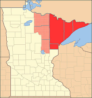
The Arrowhead Region is located in the northeastern part of the U.S. state of Minnesota, so called because of its pointed shape. The predominantly rural region encompasses 10,635.26 square miles (27,545.2 km2) of land area and includes Carlton, Cook, Lake and Saint Louis counties. Its population at the 2000 census was 248,425 residents. The region is loosely defined, and Aitkin, Itasca, and Koochiching counties are sometimes considered as part of the region, increasing the land area to 18,221.97 square miles (47,194.7 km2) and the population to 322,073 residents. Primary industries in the region include tourism and iron mining.

References

  1. "Minnesota Place Names". Minnesota Historical Society. Archived from the original on June 20, 2012. Retrieved March 19, 2014.
  2. Chicago and North Western Railway Company (1908). A History of the Origin of the Place Names Connected with the Chicago & North Western and Chicago, St. Paul, Minneapolis & Omaha Railways. p. 164.
  3. 1 2 "State & County QuickFacts". United States Census Bureau. Retrieved April 8, 2023.
  4. "2010 Census Gazetteer Files". United States Census Bureau. August 22, 2012. Archived from the original on September 21, 2013. Retrieved October 25, 2014.
  5. 1 2 Ripley, George; Dana, Charles A., eds. (1879). "Saint Louis. I. A N. E. county of Minnesota"  . The American Cyclopædia .
  6. "7 km NE of Hibbing, Minnesota, United States 7/1/1983". Microsoft Research Terraserver. USGS. Archived from the original on October 25, 2012. Retrieved June 17, 2011. See USGS map sheet "Hibbing Quadrangle", Minnesota-St. Louis county, 7.5 minute series, the "three-way watershed" marker is located at a spot on the hill about 375 meters south of the truck shop on the property of Hibbing Taconite mining company.
  7. Jennifer Bjorhus (January 16, 2019). "U scientists: Minnesota is one of the nation's fastest-warming states". Star Tribune. Retrieved January 30, 2019. said Tracy Twine, an associate professor in the University of Minnesota's Department of Soil, Water and Climate. "We just don't expect temperatures to be below 10 degrees Fahrenheit in Duluth anymore," Twine said.
  8. "Weather-related closings and cancellations for this week". Duluth News Tribune . January 29, 2019. Retrieved January 30, 2019. Duluth Public Schools - closed Tuesday and Wednesday
  9. "Here's how Global Warming leads to colder winters in the Northeast". ThinkProgress . January 24, 2019. Retrieved April 29, 2020.
  10. "Annual Estimates of the Resident Population for Counties: April 1, 2020 to July 1, 2023" . Retrieved March 18, 2024.
  11. "U.S. Decennial Census". United States Census Bureau. Retrieved October 25, 2014.
  12. "Historical Census Browser". University of Virginia Library. Retrieved October 25, 2014.
  13. "Population of Counties by Decennial Census: 1900 to 1990". United States Census Bureau. Retrieved October 25, 2014.
  14. "Census 2000 PHC-T-4. Ranking Tables for Counties: 1990 and 2000" (PDF). United States Census Bureau. Archived (PDF) from the original on March 27, 2010. Retrieved October 25, 2014.
  15. "P2 HISPANIC OR LATINO, AND NOT HISPANIC OR LATINO BY RACE - 2010: DEC Redistricting Data (PL 94-171) - St. Louis County, Minnesota". United States Census Bureau .
  16. "P2 HISPANIC OR LATINO, AND NOT HISPANIC OR LATINO BY RACE - 2020: DEC Redistricting Data (PL 94-171) - St. Louis County, Minnesota". United States Census Bureau .
  17. "2015 American Community Survey". Archived from the original on February 13, 2020. Retrieved August 22, 2017.
  18. . Uselectionatlas.org
  19. St. Louis County considers a split|Minnesota Public Radio News. Minnesota.publicradio.org (July 30, 2007; accessed July 12, 2013.)
  20. "Presidential election of 1928 - Map by counties". geoelections.free.fr.
  21. "Hibbing voters tapped GOP Trump change", Minnesota Public Radio News, November 9, 2016
  22. Leip, David. "Atlas of US Presidential Elections". uselectionatlas.org.
  23. Carson Lake. Hibbing Historical Society and Museum. Accessed April 11, 2021.

47°35′N92°28′W / 47.58°N 92.46°W / 47.58; -92.46