
Tremé is a neighborhood in New Orleans, Louisiana. "Tremé" is often rendered as Treme, and the neighborhood is sometimes called by its more formal French name, the Faubourg Tremé; it is listed in the New Orleans City Planning Districts as Tremé / Lafitte when including the Lafitte Projects.

The Faubourg Marigny is a neighborhood of the city of New Orleans, Louisiana, United States.

Canal Street is a major thoroughfare in the city of New Orleans. Forming the upriver boundary of the city's oldest neighborhood, the French Quarter or Vieux Carré, it served historically as the dividing line between the colonial-era (18th-century) city and the newer American Sector, today's Central Business District.

Bywater is a neighborhood of the city of New Orleans. A subdistrict of the Bywater District Area, its boundaries as defined by the City Planning Commission are: Florida Avenue to the north, the Industrial Canal to the east, the Mississippi River to the south, and the railroad tracks along Homer Plessy Way to the west. Bywater is part of the Ninth Ward of New Orleans. It includes part or all of Bywater Historic District, which is listed on the National Register of Historic Places.

The Ninth Ward or 9th Ward is a distinctive region of New Orleans, Louisiana, which is located in the easternmost downriver portion of the city. It is geographically the largest of the 17 Wards of New Orleans. On the south, the Ninth Ward is bounded by the Mississippi River. On the western or "upriver" side, the Ninth Ward is bounded by Franklin Avenue, then Almonaster Avenue, then People's Avenue. From the north end of People's Avenue the boundary continues on a straight line north to Lake Pontchartrain; this line is the boundary between the Ninth and the city's Eighth Ward. The Lake forms the north and northeastern end of the ward. St. Bernard Parish is the boundary to the southeast, Lake Borgne farther southeast and east, and the end of Orleans Parish to the east at the Rigolets.
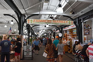
The French Market is a market and series of commercial buildings spanning six blocks in the French Quarter of New Orleans, Louisiana. Founded as a Native American trading post predating European colonization, the market is the oldest of its kind in the United States. It began where Café du Monde currently stands and has been rebuilt and renovated a number of times.

The Lower Ninth Ward is a neighborhood in the city of New Orleans, Louisiana. As the name implies, it is part of the 9th Ward of New Orleans. The Lower Ninth Ward is often thought of as the entire area within New Orleans downriver of the Industrial Canal; however, the City Planning Commission divides this area into the Lower Ninth Ward and Holy Cross neighborhoods.

The New Orleans Public Library (NOPL) is the public library of the city of New Orleans, Louisiana, United States. Succeeding earlier libraries in the city, it opened in 1897. Three branches were added by 1908. Carnegie library branches were added in 1911 and 1915. By 2005 a dozen branches were open. The main library is listed on the National Register of Historic Places.

Broadmoor is a neighborhood of the city of New Orleans. A subdistrict of the Uptown/Carrollton Area, its boundaries as defined by the New Orleans City Planning Commission are: Eve Street to the north, Washington Avenue and Toledano Street to the east, South Claiborne Avenue to the south, and Jefferson Avenue, South Rocheblave Street, Nashville Avenue, and Octavia Street to the west. It includes the Broadmoor Historic District which was listed on the National Register of Historic Places in 2003 and increased in its boundaries in 2007.

Central City is a neighborhood of the city of New Orleans. It is located in the 11th Ward of New Orleans in Uptown, just above the Garden District, on the "lakeside" of St. Charles Avenue. A subdistrict of the Central City/Garden District Area, its boundaries as defined by the City Planning Commission are: MLK Boulevard, South Claiborne Avenue and the Pontchartrain Expressway to the north, Magazine, Thalia, Prytania and Felicity Streets and St. Charles Avenue to the south and Toledano Street, Louisiana Avenue and Washington Avenue to the west. This old predominantly African-American neighborhood has been important in the city's brass band and Mardi Gras Indian traditions.

The 8th Ward is a section of New Orleans, Louisiana. It is one of the Downtown Wards of New Orleans, with a Creole history.

The 7th Ward is a legally defined voting ward and a neighborhood of the city of New Orleans. A sub-district of the Mid-City District Area, its boundaries as defined by the New Orleans City Planning Commission are: A.P. Tureaud Avenue, Agriculture, Allen, Industry, St. Anthony, Duels, Frenchmen and Hope Streets to the north, Elysian Fields Avenue to the east, St. Claude and St. Bernard Avenues, North Rampart Street and Esplanade Avenue to the south, and North Broad Street to the west.

Gentilly is a broad, predominantly middle-class and racially diverse section of New Orleans, Louisiana. The Gentilly neighborhood is bounded by Lake Pontchartrain to the north, France Road to the east, Bayou St. John to the west, and CSX Transportation railroad tracks to the south.

Lakeview is a neighborhood of the city of New Orleans. A subdistrict of the Lakeview District Area, its boundaries as defined by the City Planning Commission are: Allen Toussaint Boulevard to the north, Orleans Avenue to the east, Florida Boulevard, Canal Boulevard and I-610 to the south and Pontchartrain Boulevard to the west. Lakeview is sometimes used to describe the entire area bounded by Lake Pontchartrain to the north, the Orleans Avenue Canal to the east, City Park Avenue to the south and the 17th Street Canal to the west. This larger definition includes the West End, Lakewood and Navarre neighborhoods, as well as the Lakefront neighborhoods of Lakeshore and Lake Vista.

St. Bernard Projects was a housing project in the city of New Orleans. A subdistrict of the Mid-City District Area, its boundaries as defined by the New Orleans City Planning Commission were: Harrison Avenue to the north, Paris Avenue to the east, Lafreniere Street and Florida Avenue to the south and Bayou St. John to the west.
Crescent City Farmers Market is an agricultural market in New Orleans, Louisiana.

Charity Hospital was one of two teaching hospitals which were part of the Medical Center of Louisiana at New Orleans (MCLNO), the other being University Hospital. Three weeks after the events of Hurricane Katrina, then-Governor Kathleen Blanco said that Charity Hospital would not reopen as a functioning hospital. The Louisiana State University System, which owns the building, stated that it had no plans to reopen the hospital in its original location. It chose to incorporate Charity Hospital into the city's new medical center in the lower Mid-City neighborhood. The new hospital completed in August 2015 was named University Medical Center New Orleans.
St. Claude is a neighborhood of the city of New Orleans. A subdistrict of the Bywater District Area, its boundaries as defined by the City Planning Commission are: Law, Montegut and North Galvez Streets to the north, Lesseps Street to the east, Burgundy Street, Clouet Street and St. Claude Avenue to the south and Franklin Avenue to the west.

St. Roch is a neighborhood of the U.S. city of New Orleans. A subdistrict of the Bywater District Area, its boundaries as defined by the City Planning Commission are: Lafreniere Street, Paris Avenue, I-610, Benefit Street, and Dahlia Walk to the north; People's and Almonaster Avenues to the east; St. Claude Avenue to the south; Elysian Fields Avenue, Hope, Frenchmen, Duels, St. Anthony, Industry, Allen, & Agriculture Streets, A.P. Tureaud Avenue, Abundance, Republic, Treasure, & Dugue Streets, and Florida & St. Bernard Avenues to the west.

Marigny Opera House, also known as the Church of the Arts, is an opera house and performing arts center in Faubourg Marigny, New Orleans, Louisiana. The Marigny was originally a Catholic parish church known as Holy Trinity Catholic Church. It was closed by the Archdiocese of New Orleans in 1997.


