Luffield Abbey is a place in the very north of Buckinghamshire, England. It is on the border with Northamptonshire, close to Biddlesden and Silverstone.

Saint Tudwal's Islands are a small archipelago lying south of Abersoch on the Llŷn Peninsula in North Wales, at the western end of Tremadog Bay. They were apparently referred to as the Studwells in the early 19th century.
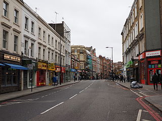
The A3220 is a primary A road in London. It runs north from Clapham Common to the A40 Westway at Ladbroke Grove.
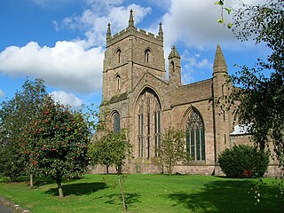
The Priory Church is an Anglican parish church in Leominster, Herefordshire, England, dedicated to Saint Peter and Saint Paul. The building was constructed for a Benedictine Priory in about the 13th century, although there had been an Anglo-Saxon monastery in Leominster, possibly on the same site. In 1539 the east end of the church was destroyed along with most of the monastic buildings, but the main body of the church was preserved.

Snelshall Priory was a Benedictine priory in Milton Keynes, Buckinghamshire in the United Kingdom, built around 1200. The priory was founded after Sybil d'Aungerville granted land at Tattenhoe to Lavendon Abbey, a Premonstratensian monastery of 'White canons' who most likely started a cell at Snelshall. This did not thrive and was abandoned about 1207. About 1219, the founder's son brought in Benedictine monks, increased the endowment and the new monastery began again. However Snelshall Priory paid 1 mark a year to Lavendon until 1232, at which point the Bishop of Lincoln decided that Snelshall owned its own lands and chapel. The priory accumulated various land through gifts, but even with all these grants, in 1321 when Henry Burghersh visited, it was so poor that "the monks scarcely had the necessities of life and had to beg even for these".

The University of the French West Indies is a French public university, based in the French West Indies.

St Oswald's Priory was founded by Æthelflæd, daughter of Alfred the Great, and her husband Æthelred, ealdorman of Mercia, in the late 880s or the 890s.
Huntingdon Priory was an Augustinian Priory in Cambridgeshire, England. Founded before A.D. 973 in or near the parochial church of St Mary's Church, it was moved by Eustace de Lovetot away from Huntingdon, either in the time of Henry II, where it continued till its dissolution in 1538.
Standon Priory was a priory in Essex, England.
Clifford Priory was a priory in Herefordshire, England at grid reference SO2531944576.
Saint Guthlac's Priory was a Benedictine priory in Hereford, England at grid reference SO51534019. a site between the present day Bath Street and Commercial Road. Upon the dissolution of the monasteries John Prise bought the priory of St. Guthlac, Hereford.
Boston Priory was a priory in Boston, Lincolnshire, England.
Bridgend Priory was a monastic house in Horbling, Lincolnshire, England.

Deeping St James Priory was a priory in Deeping St James, Lincolnshire, England. In 1139 Baldwin Fitz Gilbert established the Benedictine Priory of Saint James at Deeping as a cell of Thorney Abbey. The cell was dissolved at the surrender of Thorney in 1539. The priory church remains as the Church of England parish church of Deeping St James and is a Grade I listed building.
Gokewell Priory was a Cistercian Catholic priory in Broughton, Lincolnshire, England..
Long Bennington Priory was a priory in Lincolnshire, England.
Newstead Priory was a priory in Lincolnshire, England, between Stamford and Uffington.

St Leonard's Priory, Stamford was a priory in Lincolnshire, England. It was built in Stamford, supposedly on the site of a monastery which was founded by St Wilfrid in 658 and destroyed in the Danish invasion.

Monks Kirby Priory was a priory, at first Benedictine and later Carthusian, in Monks Kirby, Warwickshire, England.
Astley Priory was a Benedictine priory in Astley, Worcestershire, England.


