Stannington, Northumberland

Last updated

Stannington
St Mary's Church Stannington.jpg
St Mary's Church
Northumberland UK location map.svg
Red pog.svg
Stannington
Location within Northumberland
Population1,219 (2001 census) [1]
OS grid reference NZ215795
Unitary authority
Ceremonial county
Region
Country England
Sovereign state United Kingdom
Post town MORPETH
Postcode district NE61
Dialling code 01670
Police Northumbria
Fire Northumberland
Ambulance North East
UK Parliament
List of places
UK
England
Northumberland
55°06′36″N1°39′43″W / 55.110°N 1.662°W / 55.110; -1.662

Stannington is a village and civil parish in Northumberland, England. The population of the civil parish was 1,219 at the 2001 Census, increasing to 1,280 at the 2011 Census. [2] Stannington is divided into three: Stannington North-East Quarter, Stannington North-West Quarter and Stannington South Quarter. The total area of Stannington, including Stannington Vale, is 10,093 acres (40.84 km2).

Contents

Buildings

St Mary's church

Stannington's oldest building is the church, dedicated to St Mary The Virgin. The original church on that site dated back to 1190AD.

Most of the current church was constructed in 1871, to a design by R J Johnson of Newcastle, at a cost of £6,000. [3] It incorporates the 13th-century north arcade of the medieval church, and some medieval stained glass and grave covers. [4]

The old vicarage, built in 1745, stands near the church, with the current vicarage behind. [5]

Hospitals

There were two hospitals in the village. Stannington Children's Hospital was the first children's tuberculosis hospital in the country; St. Mary's Hospital was an asylum originally known as the Gateshead Lunatic Asylum. Both are now closed. [3] One former hospital north-east of the village near Netherton was built in the 1930s and featured the Thomas Taylor retirement homes for Wansbeck residents. Behind the main complex was the Mona Taylor Maternity Hospital which was named after the leading suffragist, Mr Taylor's wife. Many children were born here until it too became an old people's home and, together with the rest of the site, was then owned by Northumberland County Council. Today this development is known as Hepscott Park with some original hospital buildings surviving in local authority use, other buildings converted into private homes and some additional new houses.

Village Hall

Stannington Village Hall is a community hub and a charming space and is available for hire whatever the occasion. The main hall seats 150 guests with a full-sized stage, sound and lighting for bands,  entertainers, or productions of any type. The two adjoining side rooms each seat 30 and enjoy a fully equipped kitchen and separate bar with a glass wash. There is adequate off street parking, a disabled entrance, level internal floors and an accessible toilet with baby changing facilities.

The hall was formally opened on 24 October 1959 and is located in the heart of Stannington Village, which is situated 10 miles North of Newcastle upon Tyne in the beautiful, unspoiled and historic county of Northumberland with easy access from the A1, just next to the Ridley Arms.

The Hall is held in Trust for the community and its daily business is run by a Management Committee, made up of volunteers and Hall users. It is a non-profit registered charity and is funded through hall charges, fundraising events and grants. The hall welcomes regular local groups such as Art Groups, WI, Craft Groups and Yoga, musical events drawing big crowds, private parties, community events, celebrations, weddings and classes of all kinds.

Other buildings

Stannington First School is located near the church. The village used to have a post office which has since been converted into a hairdresser's.

Other listed buildings in the village include two bus shelters, built in 1937 to a design by Laurence Whistler and presented to the village by Lord Ridley in commemoration of the coronation of King George VI. [6]

Transport

The A1 road arcs past the village and in instances of traffic accidents or otherwise-motivated road closures, traffic from the A1 has been diverted through the village. This section of the A1 was substantially rebuilt with two new roundabouts and new junctions in 2003 and 2004 following a fatal accident in 1999. [7]

In 1847 a railway station was opened near the village. Initially known as Netherton, it was renamed to Stannington in 1892, but passenger services ended in 1958 and the station finally closed to goods trains too in 1964. [8]

Related Research Articles

<span class="mw-page-title-main">Bradwell, Milton Keynes</span> Civil parish in Milton Keynes, England

Bradwell is an ancient village and modern district in Milton Keynes, Buckinghamshire, England. It has also given its name to a modern civil parish that is part of the City of Milton Keynes. The village was adjacent to Bradwell Abbey, a Benedictine priory, founded in 1155 and dissolved in about 1540, but the abbey and its immediate environs were always a separate ecclesiastical parish.

<span class="mw-page-title-main">Donhead St Mary</span> Human settlement in England

Donhead St Mary is a village and civil parish in southwest Wiltshire, England, on the county border with Dorset. The village lies about 2+12 miles (4.0 km) east of the Dorset town of Shaftesbury and stands on high ground above the River Nadder, which rises in the parish.

<span class="mw-page-title-main">Bellingham, Northumberland</span> Village in Northumberland, England

Bellingham is a village and civil parish in Northumberland, to the north-west of Newcastle upon Tyne and is situated on the Hareshaw Burn at its confluence with the River North Tyne.

<span class="mw-page-title-main">Ponteland</span> Human settlement in England

Ponteland is a large village and civil parish in Northumberland, England. It is 15 miles (24 km) north of Newcastle upon Tyne. The name means "island in the Pont", after the River Pont which flows from west to east and joins the River Blyth further downstream, before flowing into the North Sea.

<span class="mw-page-title-main">Alwinton</span> Human settlement in England

Alwinton is a village and former parish in Northumberland, England. Alwinton is named after the nearby River Alwin, and means farm on the River Alwin.

<span class="mw-page-title-main">Belsay</span> Human settlement in England

Belsay is a village and civil parish in Northumberland, England. The village is about 5 miles from Ponteland on the A696, which links the village with Newcastle upon Tyne and Jedburgh. The population of the civil parish was 436 at the 2001 census, increasing to 518 at the 2011 Census.

<span class="mw-page-title-main">Bywell</span> Human settlement in England

Bywell is a village and civil parish in Northumberland, England. It is situated on the north bank of the River Tyne opposite Stocksfield, between Hexham and Newcastle. The parish has a population of around 380 and Newton is now its most populous settlement.

<span class="mw-page-title-main">Ovingham</span> Village in Northumberland, England

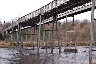
Ovingham is a civil parish and village in the Tyne Valley of south Northumberland, England. It lies on the River Tyne 10 miles (16 km) east of Hexham with neighbours Prudhoe, Ovington, Wylam and Stocksfield.

<span class="mw-page-title-main">Wark on Tyne</span> Human settlement in England

Wark on Tyne is a small village and civil parish in Northumberland, England, 12 miles (19 km) north of Hexham.

<span class="mw-page-title-main">East Cowick</span> Village in the East Riding of Yorkshire, England

East Cowick is a village in the East Riding of Yorkshire, England, situated approximately 1.5 miles (2.4 km) east of Snaith. It lies on the A1041 road and just north of the M62 motorway. It was historically part of the West Riding of Yorkshire until 1974.

<span class="mw-page-title-main">Blagdon Hall</span>

Blagdon Hall is a privately owned English country house near Cramlington in Northumberland. It is a Grade I listed building. The house and estate have been in the ownership of the White Ridley family since 1698. The present Viscount Ridley is the science writer and hereditary peer Matt Ridley.

<span class="mw-page-title-main">Longframlington</span> Human settlement in England

Longframlington is a small village in Northumberland, England, located on the A697, 11 miles (18 km) north-west of Morpeth and 5 miles (8 km) south-east of Rothbury. Longframlington is a former pit village and on the site of the pit now stands Fram Park, a log cabin holiday park. The village was previously the site of the Longframlington Music Festival.

<span class="mw-page-title-main">Bricklehampton</span> Village in Worcestershire, England

Bricklehampton is a village and civil parish in Worcestershire, England. In the 2021 census the population of the parish was recorded as 236. Its area is 369.7 hectares (1.427 sq mi). The village shares a parish council with Elmley Castle and Netherton.

<span class="mw-page-title-main">Marston Meysey</span> Human settlement in England

Marston Meysey, pronounced and sometimes also spelt Marston Maisey, is a village and civil parish in Wiltshire, England, lying 3 miles (5 km) northeast of Cricklade on the county boundary with Gloucestershire. The parish includes the hamlet of Marston Hill. Marston Maisey is the spelling for the civil parish, but not for the village on Ordnance Survey maps.

<span class="mw-page-title-main">Kirklinton</span> Human settlement in England

Kirklinton is a village in the Carlisle district, in the English county of Cumbria. The population of the civil parish of Kirklinton Middle, taken at the 2011 census was 384. It is a few miles away from the large village of Longtown. It has a church called St Cuthbert's Church. The parish contains the village of Smithfield.

<span class="mw-page-title-main">Stannington railway station</span> Disused railway station in Northumberland, England

Stannington railway station was a railway station which served the village of Stannington in Northumberland, England. It was located on the East Coast Main Line. It was opened in 1847 as Netherton, and closed in 1958. The community around the location of the station is today known as Stannington Station.

Goldshaw Booth is a civil parish in Pendle, Lancashire, England. It contains 14 listed buildings that are recorded in the National Heritage List for England. Of these, two are at Grade II*, the middle grade, and the others are at Grade II, the lowest grade. The parish contains the village of Newchurch in Pendle and is otherwise rural. Almost all the listed buildings in the parish are houses, farmhouses, farm buildings, and associated structures. The other listed buildings are a church and two memorials in the churchyard.

Percy Main is a small village absorbed into North Shields, North East England. Historically in Northumberland, it is now part of Tyne and Wear.

<span class="mw-page-title-main">St Mary's Hospital, Stannington</span> Hospital in England

St Mary's Hospital was a mental health facility near Stannington, Northumberland, England. It was opened in 1910 and closed permanently in 1995. It was finally demolished in 2015.

<span class="mw-page-title-main">Pencoyd</span> Human settlement in England

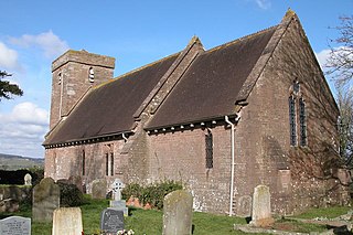
Pencoyd is a hamlet and civil parish in Herefordshire, England. The parish, which also includes the hamlet of Netherton and part of the hamlet of Harewood End, both to the east of Pencoyd hamlet, is approximately 8 miles (13 km) south from the city and county town of Hereford and 5 miles (8 km) west-northwest from the market town of Ross-on-Wye.

References

  1. Office for National Statistics: Neighbourhood Statistics
  2. "Civil Parish population 2011" . Retrieved 30 January 2016.
  3. 1 2 Northumberland Communities - Stannington
  4. Historic England. "Church of St Mary the Virgin, Church Road (Grade II) (1042627)". National Heritage List for England . Retrieved 22 October 2019.
  5. Historic England. "The Old Vicarage (Grade II) (1025120)". National Heritage List for England . Retrieved 22 October 2019.
  6. Historic England. "Bus shelter 45 metres north of footbridge (Grade II) (1042661)". National Heritage List for England . Retrieved 22 October 2019.
  7. A1 re-opening at Stannington next month - Morpeth Herald
  8. Stannington Station northumbrian-railways.co.uk