Wyoming is a state in the Mountain West subregion of the Western United States. It borders Montana to the north and northwest, South Dakota and Nebraska to the east, Idaho to the west, Utah to the southwest, and Colorado to the south. With a population of 576,851 in 2020, Wyoming is the least populous state despite being the 10th largest by area, with the second-lowest population density after Alaska. The state capital and most populous city is Cheyenne, which had an estimated population of 63,957 in 2018.

Grand Teton National Park is an American national park in northwestern Wyoming. At approximately 310,000 acres (1,300 km2), the park includes the major peaks of the 40-mile-long (64 km) Teton Range as well as most of the northern sections of the valley known as Jackson Hole. Grand Teton National Park is only 10 miles (16 km) south of Yellowstone National Park, to which it is connected by the National Park Service–managed John D. Rockefeller Jr. Memorial Parkway. Along with surrounding national forests, these three protected areas constitute the almost 18-million-acre (73,000-square-kilometer) Greater Yellowstone Ecosystem, one of the world's largest intact mid-latitude temperate ecosystems.

Teton County is a county in the U.S. state of Wyoming. As of the 2020 United States Census, the population was 23,331. Its county seat is Jackson. Its west boundary line is also the Wyoming state boundary shared with Idaho and the southern tip of Montana. Teton County is part of the Jackson, WY-ID Micropolitan Statistical Area.

Park County is a county in the U.S. state of Wyoming. As of the 2020 United States Census, the population was 29,624. The county seat is Cody.
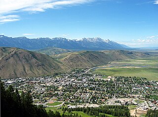
Jackson is a town in Teton County, Wyoming, United States. The population was 10,760 at the 2020 census, up from 9,577 in 2010. It is the largest town in Teton County and its county seat. Jackson is the principal town of the Jackson, WY-ID Micropolitan Statistical Area, which includes Teton County in Wyoming and Teton County in Idaho. The town, often familiarly or mistakenly called Jackson Hole, derives its name from the valley in which it is located. Jackson is a popular tourist destination due to its proximity to the ski resorts Jackson Hole Mountain, Snow King Mountain, and Grand Targhee, as well as Grand Teton National Park and Yellowstone National Park.

The Madison River is a headwater tributary of the Missouri River, approximately 183 miles (295 km) long, in Wyoming and Montana. Its confluence with the Jefferson and Gallatin rivers near Three Forks, Montana forms the Missouri River.
Jackson Hole is a valley between the Gros Ventre and Teton mountain ranges in the U.S. state of Wyoming, near the border with Idaho, in Teton County. The term "hole" was used by early trappers, or mountain men, as a term for a large mountain valley. These low-lying valleys, surrounded by mountains and containing rivers and streams, are good habitat for beavers and other fur-bearing animals. Jackson Hole is 55 miles (89 km) long by 6-to-13 miles (10-to-21 km) wide and is a graben valley with an average elevation of 6,800 ft, its lowest point being near the southern park boundary at 6,350 ft.

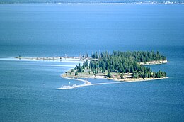
Jackson Lake is in Grand Teton National Park in northwestern Wyoming. This natural lake was enlarged by the construction of the Jackson Lake Dam, which was originally built in 1911, enlarged in 1916 and rebuilt by 1989. As part of the Minidoka Project the top 33 ft (10 m) of the lake is used by farmers in Idaho for irrigation purposes under water rights legislation that was enacted prior to the establishment of Grand Teton National Park. The lake is the remnant of large glacial gouging from the neighboring Teton Range to the west and the Yellowstone Plateau to the north. The lake is primarily fed by the Snake River, which flows in from the north, and empties at Jackson Lake Dam. Jackson Lake is one of the largest high altitude lakes in the United States, at an elevation of 6,772 ft (2,064 m) above sea level. The lake is up to 15 mi (24 km) long, 7 mi (11 km) wide and 438 ft (134 m) deep. The water of the lake averages below 60 °F (16 °C), even during the summer.

Grand Teton is the highest mountain in Grand Teton National Park, in Northwest Wyoming, and a classic destination in American mountaineering.

John D. Rockefeller Jr. Memorial Parkway is a scenic road and protected area that connects Grand Teton National Park and Yellowstone National Park in the U.S. state of Wyoming. It is federally owned and managed by the National Park Service by Grand Teton National Park. It is named in remembrance of John D. Rockefeller Jr., a conservationist and philanthropist who was instrumental in the creation and enlargement of numerous national parks including Grand Teton, Virgin Islands, Acadia and the Great Smoky Mountains. This parkway carries U.S. Route 89, U.S. Route 191, and U.S. Route 287

Bridger–Teton National Forest is located in western Wyoming, United States. The forest consists of 3.4 million acres, making it the third largest National Forest outside Alaska. The forest stretches from Yellowstone National Park, along the eastern boundary of Grand Teton National Park and from there rides along the western slope of the Continental Divide to the southern end of the Wind River Range. The forest also extends southward encompassing the Salt River Range and Wyoming Range mountains near the Idaho border.

Caribou–Targhee National Forest is located in the states of Idaho and Wyoming, with a small section in Utah in the United States. The forest is broken into several separate sections and extends over 2.63 million acres (10,600 km2). To the east the forest borders Yellowstone National Park, Grand Teton National Park and Bridger–Teton National Forest. Most of the forest is a part of the 20-million-acre (81,000 km2) Greater Yellowstone Ecosystem.

Signal Mountain is an isolated summit standing 7,720 feet (2,350 m) above sea level. The mountain is located in Grand Teton National Park in the U.S. state of Wyoming. The next closest higher summit is more than 10 miles (16 km) distant, and this isolation provides sweeping views of the Teton Range, much of the northern Jackson Hole area as well as the Snake River. Though located adjacent to the Tetons, Signal Mountain was not formed in the same manner or period. The mountain originally was formed by volcanic ashfall from one of the eruptions of the Yellowstone hotspot. The peak is also partially a glacial moraine formed by a receding glacier that came south out of the Yellowstone icecap. This same glacier also created neighboring Jackson Lake.

The U.S. state of Wyoming lies in the Mountain West subregion of the Western United States and has a varied geography. It is bordered by Montana to the north and northwest, South Dakota and Nebraska to the east, Idaho to the west, Utah to the southwest, and Colorado to the south. Wyoming is the least populous U.S. state and has the second-lowest population density behind Alaska.
Moran is an unincorporated village in south central Teton County, Wyoming, United States: as the community has had two different names, the Board on Geographic Names officially ruled in favor of "Moran" in 1970. It lies in Grand Teton National Park, 29 miles northeast of the city of Jackson, the county seat of Teton County, just northwest by side road of the intersection of U.S. Routes 26, 89, 191 and 287. Its elevation is 6,749 feet (2,057 m) and includes one of the principal entrance-fee collection stations for the Park. Moran also has the post office serving ZIP code of 83013, and a public elementary school; and no other services or businesses.

The Teton–Yellowstone tornado was a rare high-altitude tornado which occurred on July 21, 1987, in the U.S. state of Wyoming. Rated at F4 on the Fujita scale, it remains the strongest tornado ever recorded in the state and the only recorded F4/EF4 tornado in Wyoming history. The tornado cut through a 39.2-kilometre (24.4 mi)-long and 2.5-kilometre (1.6 mi)-wide swath of the Teton Wilderness and Yellowstone National Park, crossing the Continental Divide. Damage occurred at elevations ranging from 8,500 to 10,000 feet, making it the highest-altitude violent tornado recorded in the United States. At the time, it was the highest-elevation tornado known, since surpassed by several others, including a 2004 tornado above 12,000 feet in California's Sequoia National Park. While no human fatalities or injuries occurred, an estimated one million trees were felled by the tornado. The tornado damage was originally thought to be the result of strong thunderstorm straight-line winds until the area was surveyed by University of Chicago severe weather meteorologist Ted Fujita and his colleagues, who published a paper in 1989 surveying the tornado's path and discussing its meteorological character.

The Teton Crest Trail is a 40-mile (64 km) long hiking trail in the U.S. state of Wyoming that extends from Phillips Pass, on the border of Bridger Teton and Caribou-Targhee National Forests, to String Lake in Grand Teton National Park. Backpacker Magazine calls the Trail one of the "Best Hikes Ever," with "mesmerizing and constant views of jagged peaks."

Owl Peak is in the northern Teton Range, Grand Teton National Park, Wyoming and is just east of Elk Mountain. The peak is located west of and across Jackson Lake from Lizard Creek Campground. Access to the peak is easiest by boat to the Berry Creek Trailhead at Wilcox Point then heading west at the Owl Creek Trail. After a 2 miles (3.2 km) hike along Berry Creek and Owl Creek trails, off trail access to the summit can be achieved after a steep ascent of an additional 2 miles (3.2 km). North of the mountain, the Tetons blend into the Yellowstone Plateau while to the south lies Webb Canyon.

Top Notch Peak is a 10,245-foot-elevation (3,123 meter) mountain summit located in Yellowstone National Park, in Park County, Wyoming, United States.

Two Ocean Mountain is a 10,724-foot-elevation (3,269-meter) summit in Teton County, Wyoming, United States.