Stockton Springs, Maine

Last updated

Stockton Springs, Maine
Fort point light station.jpg
Waldo County Maine Incorporated Areas Stockton Springs Highlighted.png
Location of Stockton Springs (in yellow) in Waldo County and the state of Maine
Coordinates: 44°29′36″N68°50′55″W / 44.49333°N 68.84861°W / 44.49333; -68.84861
CountryUnited States
State Maine
County Waldo
Incorporated 1857
Area
[1]
  Total29.83 sq mi (77.26 km2)
  Land19.64 sq mi (50.87 km2)
  Water10.19 sq mi (26.39 km2)
Elevation
89 ft (27 m)
Population
 (2020)
  Total1,533
  Density78/sq mi (30.1/km2)
Time zone UTC−5 (Eastern (EST))
  Summer (DST) UTC−4 (EDT)
ZIP Code
04981
Area code 207
FIPS code 23-74475
GNIS feature ID0582749

Stockton Springs is a town in Waldo County, Maine, United States. The population was 1,533 at the 2020 census. [2] Stockton Springs is home to Fort Point State Park and Fort Point Light, both located on Fort Point, a peninsula on Cape Jellison.

Contents

History

Part of the Waldo Patent, it was first settled about 1759, the year Governor Thomas Pownall completed Fort Pownall on Fort Point. [3] The defense was intended to guard the mouth of the Penobscot River estuary during the French and Indian War. Fort Pownall was burned in 1775 and 1779 by the British themselves, to prevent it from falling into the hands of Americans. [4]

On February 29, 1794, the area was incorporated as part of Prospect, but then set off and incorporated as a town on March 13, 1857, named Stockton after a port in England. [5] In 1859, businesses included four sawmills, three shingle mills, two lath mills, one carding machine, one cloth-dressing mill, one tannery, four shipyards, six blacksmith shops, and several mechanic shops. By 1886, it also had a shoe factory, cheese factory, a door, sash and blind factory, cask and barrel makers, and a clothing factory. [6] On February 5, 1889, the town's name was changed to Stockton Springs in anticipation of bottling local spring water. When sediment was discovered in the bottles, however, the plan was abandoned.

Cape Jellison developed into a bustling port. Between 1905 and 1907, three huge wooden piers were built, the biggest 1,750 feet (530 meters) in length. The Bangor & Aroostook Railroad transported goods to and from the docks. An immense warehouse held potatoes from Aroostook County until schooners could deliver them elsewhere. The wharves were destroyed in a fire on November 8, 1924, [7] ending the harbor's industrial era.

Geography

According to the United States Census Bureau, the town has a total area of 29.83 square miles (77.26 km2), of which 19.64 square miles (50.87 km2) is land and 10.19 square miles (26.39 km2) is water. [1] Stockton Springs is located on Penobscot Bay, part of the Gulf of Maine, Atlantic Ocean.

The town is crossed by U.S. Route 1, U.S. Route 1A and Maine State Route 3.

Demographics

Historical population
CensusPop.Note
1860 1,595
1870 2,08931.0%
1880 1,548−25.9%
1890 1,149−25.8%
1900 872−24.1%
1910 1,10326.5%
1920 1,1756.5%
1930 877−25.4%
1940 9053.2%
1950 9494.9%
1960 9803.3%
1970 1,14216.5%
1980 1,2307.7%
1990 1,38512.6%
2000 1,4816.9%
2010 1,5917.4%
2020 1,533−3.6%
U.S. Decennial Census [8]

2010 census

As of the census [9] of 2010, there were 1,591 people, 694 households, and 471 families residing in the town. The population density was 81.0 inhabitants per square mile (31.3/km2). There were 939 housing units at an average density of 47.8 per square mile (18.5/km2). The racial makeup of the town was 96.7% White, 0.4% African American, 0.8% Native American, 0.9% Asian, 0.1% from other races, and 1.3% from two or more races. Hispanic or Latino of any race were 0.8% of the population.

There were 694 households, of which 23.6% had children under the age of 18 living with them, 55.2% were married couples living together, 8.4% had a female householder with no husband present, 4.3% had a male householder with no wife present, and 32.1% were non-families. Of all households, 25.1% were made up of individuals, and 12.3% had someone living alone who was 65 years of age or older. The average household size was 2.29 and the average family size was 2.70.

The median age in the town was 49.9 years. Of residents, 17.3% were under the age of 18; 6.6% were between the ages of 18 and 24; 18.3% were from 25 to 44; 37.4% were from 45 to 64; and 20.4% were 65 years of age or older. The gender makeup of the town was 47.3% male and 52.7% female.

2000 census

As of the census [10] of 2000, there were 1,481 people, 628 households, and 428 families residing in the town. The population density was 75.6 inhabitants per square mile (29.2/km2). There were 750 housing units at an average density of 38.3 per square mile (14.8/km2). The racial makeup of the town was 96.69% White, 0.41% African American, 0.54% Native American, 0.34% Asian, 0.07% Pacific Islander, 0.07% from other races, and 1.89% from two or more races. Hispanic or Latino of any race were 0.81% of the population.

There were 628 households, out of which 28.7% had children under the age of 18 living with them, 55.7% were married couples living together, 8.8% had a female householder with no husband present, and 31.7% were non-families. Of all households, 24.7% were made up of individuals, and 10.2% had someone living alone who was 65 years of age or older. The average household size was 2.36 and the average family size was 2.82.

In the town, the population was spread out, with 23.8% under the age of 18, 5.5% from 18 to 24, 27.9% from 25 to 44, 29.0% from 45 to 64, and 13.9% who were 65 years of age or older. The median age was 41 years. For every 100 females, there were 93.6 males. For every 100 females age 18 and over, there were 92.3 males.

The median income for a household in the town was $37,050, and the median income for a family was $42,847. Males had a median income of $34,886 versus $23,750 for females. The per capita income for the town was $18,370. About 8.5% of families and 12.1% of the population were below the poverty line, including 18.8% of those under age 18 and 6.5% of those age 65 or over.

Sites of interest

See also

Related Research Articles

<span class="mw-page-title-main">Portage Lake, Maine</span> Town in the state of Maine, United States

Portage Lake is a town in Aroostook County, Maine, United States. The population was 359 at the 2020 census.

<span class="mw-page-title-main">Pownal, Maine</span> Town in Maine, United States

Pownal is a town in Cumberland County, Maine, United States. Pownal was included in the Lewiston-Auburn, Maine metropolitan New England city and town area. The population was 1,566 at the 2020 census. It is part of the Portland–South Portland–Biddeford, Maine Metropolitan Statistical Area. Pownal is home to Bradbury Mountain State Park.

<span class="mw-page-title-main">Verona Island, Maine</span> Town in Maine, United States

Verona Island is a town located on an island of the same name in the Penobscot River in Hancock County, Maine, United States. The population was 507 at the 2020 census.

<span class="mw-page-title-main">Edgecomb, Maine</span> Town in Maine, United States

Edgecomb is a town in Lincoln County, Maine, United States. The population was 1,188 at the 2020 census. It includes the neighborhoods of East Edgecomb, North Edgecomb, and Pools Landing. The town was named for George Edgcumbe, 1st Earl of Mount Edgcumbe, a supporter of the colonists. Fort Edgecomb is a Maine State Historic Site.

<span class="mw-page-title-main">Charleston, Maine</span> Town in the state of Maine, United States

Charleston is a town in Penobscot County, Maine, United States. It is part of the Bangor Metropolitan Statistical Area. The population was 1,558 at the 2020 census. Charleston includes the village of West Charleston and is home to the Higgins Classical Institute, a Christian school.

Eddington is a town located on the eastern side of the Penobscot River in Penobscot County, Maine, United States. As of the 2020 census, the town had a population of 2,194.

<span class="mw-page-title-main">Burnham, Maine</span> Town in the state of Maine, United States

Burnham is a town in Waldo County, Maine, United States. The population was 1,096 at the 2020 census.

<span class="mw-page-title-main">Frankfort, Maine</span> Town in the state of Maine, United States

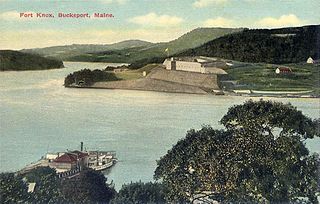
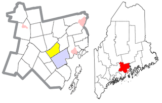
Frankfort is a town on the Penobscot River estuary in Waldo County, Maine, United States. The population was 1,231 at the 2020 census.

<span class="mw-page-title-main">Jackson, Maine</span> Town in the state of Maine, United States

Jackson is a town in Waldo County, Maine, United States. The town was named after General Henry Jackson of the Revolutionary War. The population was 610 at the 2020 census.

<span class="mw-page-title-main">Lincolnville, Maine</span> Town in the state of Maine, United States

Lincolnville is a town in Waldo County, Maine, United States. The population was 2,312 at the 2020 census. Lincolnville is the mainland terminal for Maine State Ferry Service transport to Islesboro.

<span class="mw-page-title-main">Monroe, Maine</span> Town in the state of Maine, United States

Monroe is a town in Waldo County, Maine, United States named for President James Monroe. The population was 931 at the 2020 census.

<span class="mw-page-title-main">Montville, Maine</span> Town in the state of Maine, United States

Montville is a town in Waldo County, Maine, United States. The population was 1,020 at the 2020 census.

<span class="mw-page-title-main">Prospect, Maine</span> Town in the state of Maine, United States

Prospect is a town in Waldo County, Maine, United States. The population was 698 at the 2020 census.

<span class="mw-page-title-main">Searsmont, Maine</span> Town in the state of Maine, United States

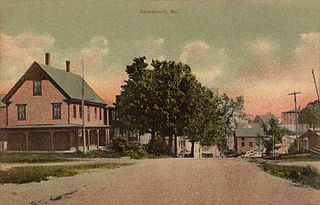
Searsmont is a town in Waldo County, Maine, United States. The population was 1,400 at the 2020 census.

<span class="mw-page-title-main">Swanville, Maine</span> Town in the state of Maine, United States

Swanville is a town in Waldo County, Maine, United States. The population was 1,377 at the 2020 census.

<span class="mw-page-title-main">Troy, Maine</span> Town in the state of Maine, United States

Troy is a town in Waldo County, Maine, United States. The population was 1,018 at the 2020 census.

<span class="mw-page-title-main">Waldo, Maine</span> Town in the state of Maine, United States

Waldo is a town in Waldo County, Maine, United States. The population was 795 at the 2020 census. It is the home town of Heather Hemmens, who is known for her role on Hellcats.

<span class="mw-page-title-main">Fort Fairfield, Maine</span> Town in the state of Maine, United States

Fort Fairfield is a town in Aroostook County, eastern Maine, United States, located along the Canada–US border. The population was 3,322 at the 2020 census.

<span class="mw-page-title-main">Searsport, Maine</span> Town in Maine, United States

Searsport is an incorporated town and deep water seaport located at the confluence of the Penobscot River estuary and the Penobscot Bay immediately northwest of Sears Island and Cape Jellison in Waldo County, Maine, United States. The population was 2,649 at the 2020 census. Searsport includes the village of North Searsport. The town is known as "the home of the famous sea captains" and the "Antique Capital of Maine".

Unity is a town in Waldo County, Maine, United States. The population was 2,292 at the 2020 census. The town is the service center for the northern portion of Waldo County. Outside of Waldo County, it is best known as the home of the Maine Organic Farmers and Gardeners Association, its Common Ground Country Fair and Unity College. Unity College was founded in 1965 to offset the economic effects of the declining chicken farming industry. As of 2007, the college is the town's largest employer.

References

  1. 1 2 "US Gazetteer files 2010". United States Census Bureau . Retrieved December 16, 2012.
  2. "Census - Geography Profile: Stockton Springs town, Waldo County, Maine" . Retrieved January 19, 2022.
  3. Maine Department of Conservation Fort Pownall
  4. Austin J. Coolidge & John B. Mansfield, A History and Description of New England; Boston, Massachusetts 1859 (Stockton Springs)
  5. Austin J. Coolidge & John B. Mansfield, A History and Description of New England; Boston, Massachusetts 1859 (Prospect)
  6. George J. Varney, History of Stockton, Maine; Boston, Massachusetts 1886
  7. History of Cape Jellison
  8. "Census of Population and Housing". Census.gov. Retrieved June 4, 2015.
  9. "U.S. Census website". United States Census Bureau . Retrieved December 16, 2012.
  10. "U.S. Census website". United States Census Bureau . Retrieved January 31, 2008.