Stonycreek Township, Somerset County, Pennsylvania

Last updated

Stonycreek Township
Flight93memorial3.jpg
Map of Somerset County, Pennsylvania highlighting Stonycreek Township.PNG
Location of Stonycreek Township in Somerset County, Pennsylvania
Map of Pennsylvania highlighting Somerset County.svg
Country United States
State Pennsylvania
County Somerset
Area
[1]
  Total61.40 sq mi (159.02 km2)
  Land61.13 sq mi (158.33 km2)
  Water0.27 sq mi (0.69 km2)
Population
 (2020) [2]
  Total2,087
  Estimate 
(2022) [3]
2,066
  Density34.14/sq mi (13.18/km2)
Time zone UTC-5 (Eastern (EST))
  Summer (DST) UTC-4 (EDT)
FIPS code 42-111-74440

Stonycreek Township is a township in Somerset County, Pennsylvania, United States. The township takes its name from the stony creek, which flows through it and represents its western boundary. The stream takes its name from the rocky bed over which it flows for a great part of its course. Its Indian name was Sinne-Hanne or Achsin-Hanne. Hanne means a stream and especially a swift mountain stream.[ citation needed ] The population was 2,087 at the 2020 census. [2] It is part of the Johnstown, Pennsylvania, metropolitan statistical area.

Contents

Stonycreek Township garnered global attention during the September 11 attacks when United Airlines Flight 93, intended to strike the United States Capitol in Washington, D.C., crashed into a field near downtown after civilian passengers on the flight from Newark, New Jersey to San Francisco International Airport rebelled against the flight's al-Qaeda terrorist hijackers.

History

What is now Stonycreek Township was settled in 1762. Most old records call it Stony Creek. The Township was incorporated in 1792 from portions of Quemahoning Township as the last of the six original townships of Somerset County.

Glessner Bridge was added to the National Register of Historic Places in 1980. [4]

September 11 attacks

The September 11 crash site of Flight 93 UA93 crash site noborder.jpg
The September 11 crash site of Flight 93

Stonycreek Township gained global attention on September 11, 2001, when United Airlines Flight 93 crashed there. Flight 93 was one of four airliners hijacked that day as part of the Al-Qaeda terrorist attack on the United States. It is widely held that the Flight 93 hijackers intended to use the craft to target the United States Capitol. The crash resulted after the passengers of the plane attacked the hijackers in an effort to gain control of the aircraft, resulting in the terrorists deliberately crashing it to prevent them from gaining the upper hand. They learned of the plane's intended fate through cell phone calls to and from family members. All 44 people aboard the plane, including four hijackers, were killed. The site is now the location of a national memorial honoring the passengers. [5]

Flight 93 National Memorial

George W. Bush and Laura Bush visiting Stonycreek Township on September 11, 2002, the first anniversary of the attacks UAL Flight 93 ceremony.jpg
George W. Bush and Laura Bush visiting Stonycreek Township on September 11, 2002, the first anniversary of the attacks

The original temporary memorial to the passengers and crew of Flight 93 was located on a hill, about 500 yards from the crash site. On July 8, 2010, a new temporary entrance and memorial were opened at an area called "The Western Overlook". It is where the FBI set up their command center and where family members first saw the aftermath of the crash, bringing their own memorials, where visitors can leave them today. The initial phase of permanent construction of the Flight 93 National Memorial, including the visitor's center, was to be completed by the 10th anniversary in 2011. The first phase of the permanent memorial was completed, opened, and dedicated on September 10, 2011. The current design for the memorial is a modified version of the entry Crescent of Embrace by Paul and Milena Murdoch. The memorial was built around the crash site, following the plane's flight path, and protects the area of impact, known as the "Sacred Ground", which will remain protected and accessible only to family members of the passengers and crew.

Geography

Stonycreek Township is located approximately at 40.01°N by 78.88°W, about 3 miles (4.8 km) west-southwest of Indian Lake, Pennsylvania. According to the U.S. Census Bureau, the township has a total area of 61.4 square miles (159.0 km2), of which 61.1 square miles (158.3 km2) is land and 0.3 square miles (0.7 km2) (0.44%) is water. It is bordered to the northeast by Shade Township, to the northwest by Quemahoning Township, to the west by Somerset Township, to the southwest by Brothersvalley Township, and to the east by Allegheny Township. Pennsylvania Route 31 runs along the township's southwestern border with Brothersvalley Township and passes into Allegheny Township to the east. U.S. Route 30 / the Lincoln Highway runs along the township's northeastern border with Shade Township. Pennsylvania Route 160 passes through Stonycreek Township as it heads northeast from Brothersvalley Township to Shade Township. Route 160 and Route 31 intersect in Roxbury, and Route 160 and U.S. Route 30/Lincoln Highway intersect in Reels Corner.

Demographics

Historical population
CensusPop.Note
2000 2,221
2010 2,2370.7%
2020 2,087−6.7%
2022 (est.)2,066 [3] −1.0%
U.S. Decennial Census [6]

As of the 2020 census, [7] of 2000, there were 2,221 people, 820 households, and 634 families residing in the township. The population density was 36.3 inhabitants per square mile (14.0/km2). There were 1,033 housing units at an average density of 16.9/sq mi (6.5/km2). The racial makeup of the township was 98.96% White, 0.09% African American, 0.32% Native American, 0.14% Asian, 0.05% from other races, and 0.45% from two or more races. Hispanic or Latino of any race were 0.23% of the population.

There were 820 households, out of which 35.5% had children under the age of 18 living with them, 68.3% were married couples living together, 5.9% had a female householder with no husband present, and 22.6% were non-families. 18.2% of all households were made up of individuals, and 8.2% had someone living alone who was 65 years of age or older. The average household size was 2.71 and the average family size was 3.10.

In the township, the population was spread out, with 26.5% under the age of 18, 6.5% from 18 to 24, 29.4% from 25 to 44, 25.3% from 45 to 64, and 12.2% who were 65 years of age or older. The median age was 38 years. For every 100 females, there were 100.1 males. For every 100 females age 18 and over, there were 99.5 males.

The median income for a household in the township was $33,828, and the median income for a family was $38,418. Males had a median income of $30,236 versus $21,714 for females. The per capita income for the township was $14,463. About 9.6% of families and 10.8% of the population were below the poverty line, including 11.9% of those under age 18 and 3.9% of those age 65 or over.

Education

Shanksville-Stonycreek School District operates public schools.

See also

Related Research Articles

<span class="mw-page-title-main">Somerset County, Pennsylvania</span> County in Pennsylvania, United States

Somerset County is a county in the Commonwealth of Pennsylvania. As of the 2020 census, the population was 74,129. Its county seat is Somerset. The county was created from part of Bedford County on April 17, 1795, and named after the county of Somerset in England. The county is part of the Southwest Pennsylvania region of the state.

<span class="mw-page-title-main">Richland Township, Cambria County, Pennsylvania</span> Township in Pennsylvania, United States

Richland Township is a township in Cambria County, Pennsylvania, United States. The population was 12,814 at the 2010 census. It is part of the Johnstown, Pennsylvania Metropolitan Statistical Area.

<span class="mw-page-title-main">Stonycreek Township, Cambria County, Pennsylvania</span> Township in Pennsylvania, United States

Stonycreek Township is a township in Cambria County, Pennsylvania, United States. The population was 2,844 at the 2010 census, down from 3,204 at the 2000 census. It is part of the Johnstown, Pennsylvania Metropolitan Statistical Area.

<span class="mw-page-title-main">Allegheny Township, Somerset County, Pennsylvania</span> Township in Pennsylvania, United States

Allegheny Township is a township in Somerset County, Pennsylvania, United States. The population was 615 at the 2020 census. It is part of the Johnstown, Pennsylvania, Metropolitan Statistical Area.

<span class="mw-page-title-main">Boswell, Pennsylvania</span> Borough in Pennsylvania, United States

Boswell is a borough in Somerset County, Pennsylvania, United States. It is part of the Johnstown, Pennsylvania Metropolitan Statistical Area. The population was 1,221 at the 2020 census.

<span class="mw-page-title-main">Brothersvalley Township, Pennsylvania</span> Township in Pennsylvania, United States

Brothersvalley Township is a township in Somerset County, Pennsylvania, United States. The population was 2,377 at the 2020 census. It is part of the Johnstown, Pennsylvania, Metropolitan Statistical Area.

<span class="mw-page-title-main">Conemaugh Township, Somerset County, Pennsylvania</span> Township in Pennsylvania, United States

Conemaugh Township is a township in Somerset County, Pennsylvania, United States. The population was 6,760 at the 2020 census. It is part of the Johnstown, Pennsylvania, Metropolitan Statistical Area. Conemaugh Township includes the towns of Jerome, Davidsville, Tire Hill, Thomas Mills, part of Holsopple, and surrounding countryside.

<span class="mw-page-title-main">Indian Lake, Pennsylvania</span> Borough in Pennsylvania, United States

Indian Lake is a borough in Somerset County, Pennsylvania, United States. It is part of the Johnstown, Pennsylvania Metropolitan Statistical Area. The population was 391 at the 2020 census, down from 394 in 2010. Indian Lake is home to Indian Lake Golf Club, which opened in 1974, and was the first to be designed by Arnold Palmer, Northwinds Golf Course (public), Indian Lake Resort, Indian Lake Marina, and the James W. McIntyre Hiking and Biking Trail.

<span class="mw-page-title-main">Jenner Township, Pennsylvania</span> Township in Pennsylvania, United States

Jenner Township is a township in Somerset County, Pennsylvania, United States. The population was 3,703 at the 2020 census. It is part of the Johnstown, Pennsylvania, Metropolitan Statistical Area.

<span class="mw-page-title-main">Lincoln Township, Somerset County, Pennsylvania</span> Township in Pennsylvania, United States

Lincoln Township is a township in Somerset County, Pennsylvania, United States. The population was 1,456 at the 2020 census. It is part of the Johnstown, Pennsylvania, Metropolitan Statistical Area.

<span class="mw-page-title-main">Lower Turkeyfoot Township, Pennsylvania</span> Township in Pennsylvania, United States

Lower Turkeyfoot Township is a township in Somerset County, Pennsylvania, United States. The population was 543 at the 2020 census. It is part of the Johnstown, Pennsylvania, Metropolitan Statistical Area.

<span class="mw-page-title-main">Northampton Township, Somerset County, Pennsylvania</span> Township in Pennsylvania, United States

Northampton Township is a township in Somerset County, Pennsylvania, United States. The population was 303 at the 2020 census. It is part of the Johnstown, Pennsylvania, Metropolitan Statistical Area.

<span class="mw-page-title-main">Quemahoning Township, Pennsylvania</span> Township in Pennsylvania, United States

Quemahoning Township is a township in Somerset County, Pennsylvania, United States. The population was 1,838 at the 2020 census. It is part of the Johnstown, Pennsylvania, Metropolitan Statistical Area.

<span class="mw-page-title-main">Shade Township, Pennsylvania</span> Township in Pennsylvania, United States

Shade Township is a township in Somerset County, Pennsylvania, United States. The population was 2,452 at the 2020 census. It is part of the Johnstown, Pennsylvania, Metropolitan Statistical Area.

<span class="mw-page-title-main">Shanksville, Pennsylvania</span> Borough in Pennsylvania, United States

Shanksville is a borough in Somerset County, Pennsylvania, United States. It has a population of 197 as of the 2020 U.S. census. It is part of the Somerset, Pennsylvania Micropolitan Statistical Area and is located 78 miles (126 km) southeast of Pittsburgh and 226 miles (364 km) west of Philadelphia.

<span class="mw-page-title-main">Somerset Township, Somerset County, Pennsylvania</span> Township in Pennsylvania, United States

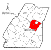
Somerset Township is a township in Somerset County, Pennsylvania, United States. The population was 12,165 at the 2020 census. It is part of the Johnstown, Pennsylvania, Metropolitan Statistical Area and encompasses the census-designated place (CDP) of Friedens.

<span class="mw-page-title-main">Stoystown, Pennsylvania</span> Borough in Pennsylvania, United States

Stoystown is a borough in Somerset County, Pennsylvania, United States. It is part of the Johnstown, Pennsylvania, Metropolitan Statistical Area. The population was 300 at the 2020 census. Stoystown is located south-southeast of Johnstown and northeast of Somerset.

<span class="mw-page-title-main">Summit Township, Somerset County, Pennsylvania</span> Township in Pennsylvania, United States

Summit Township is a township in Somerset County, Pennsylvania, United States. The population was 2,141 at the 2020 census. It is part of the Johnstown, Pennsylvania, Metropolitan Statistical Area.

<span class="mw-page-title-main">Upper Turkeyfoot Township, Pennsylvania</span> Township in Pennsylvania, United States

Upper Turkeyfoot Township is a township in Somerset County, Pennsylvania, United States. The population was 1,063 at the 2020 census. It is part of the Johnstown, Pennsylvania metropolitan statistical area.

<span class="mw-page-title-main">Flight 93 National Memorial</span> 9/11 memorial in Shanksville, Pennsylvania

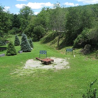
The Flight 93 National Memorial is a memorial built to commemorate the crash of United Airlines Flight 93, which was one of four aircraft hijacked during the September 11 attacks in 2001. The memorial is located in Somerset County, Pennsylvania, with the vast majority in Stonycreek Township, and with a small portion in Shade Township. It is 78 miles (126 km) southeast of Pittsburgh and 226 miles (364 km) west of Philadelphia.

References

  1. "2020 U.S. Gazetteer Files". United States Census Bureau. Retrieved March 13, 2024.
  2. 1 2 "Profile of General Population and Housing Characteristics: 2020 Demographic Profile Data (DP-1): Stonycreek township, Somerset County, Pennsylvania". United States Census Bureau . Retrieved March 13, 2024.
  3. 1 2 "City and Town Population Totals: 2020—2022". Census.gov. US Census Bureau. Retrieved March 13, 2024.
  4. "National Register Information System". National Register of Historic Places . National Park Service. July 9, 2010.
  5. "Sources and detailed information", National Park Service website
  6. "Census of Population and Housing". Census.gov. Retrieved June 4, 2016.
  7. "U.S. Census website". United States Census Bureau . Retrieved January 31, 2008.

[1] Blackburn & Welfley's "History of Bedford & Somerset Counties", 1906. Lewis Publishing Co. Vol. II, p. 641-643

39°59′00″N78°51′59″W / 39.98333°N 78.86639°W / 39.98333; -78.86639