South Sulawesi is a province in the southern peninsula of Sulawesi, Indonesia. The Selayar Islands archipelago to the south of Sulawesi is also part of the province. The capital and largest city is Makassar. The province is bordered by Central Sulawesi and West Sulawesi to the north, the Gulf of Bone and Southeast Sulawesi to the east, Makassar Strait to the west, and Flores Sea to the south.
Makassar, formerly Ujung Pandang, is the capital of the Indonesian province of South Sulawesi. It is the largest city in the region of Eastern Indonesia and the country's fifth-largest urban center after Jakarta, Surabaya, Medan, and Bandung. The city is located on the southwest coast of the island of Sulawesi, facing the Makassar Strait.

Pangandaran is a town and district of Pangandaran Regency within the province of West Java, Indonesia. It is located on the southern coast of the island of Java. A well-known surfing beach has made Pangandaran a popular tourist destination.
Polewali is the capital of the Polewali Mandar Regency of West Sulawesi, Indonesia.

Bima is a city on the eastern coast of the island of Sumbawa in central Indonesia's province of West Nusa Tenggara. It is the largest city on the island of Sumbawa, with a population of 142,443 at the 2010 census and 155,140 at the 2020 census; the official estimate as at mid-2023 was 161,362. It is separate from the adjoining Regency of Bima which had a population of 535,530 according to the mid-2023 official estimates.

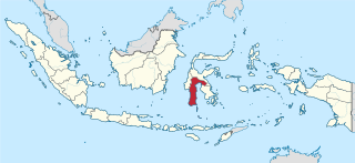
Gowa is a regency in the province of South Sulawesi, Indonesia. It has an area of 1,883.33 km2 and a population of 652,329 at the 2010 census, increasing to 765,836 at the 2020 census; the official estimate as at mid 2023 was 799,999. The majority of the regency lies within the official metropolitan area of the city of Makassar, including the regency's administrative capital at Sungguminasa. The hill resort of Malino is within the eastern (non-metropolitan) part of the regency.
Malino is a small hill town in the Gowa district of South Sulawesi, 70 km from Makassar. It is a popular getaway famous for its tropical flowers.

Bulukumba Regency is a regency in the southeast corner of South Sulawesi Province, Indonesia. It covers an area of 1,175.53 km2, and had a population of 394,757 at the 2010 Census and 437,607 at the 2020 Census; the official estimate for mid 2022 was 471,688. The town of Ujung Bulu is its capital.
The Jeneberang is a river of approximately 75 km in length in the south-western half of the island of Sulawesi, Indonesia. The catchment has an area of 760 square kilometers.
The Sadang is a river of Sulawesi in South Sulawesi province, Indonesia. It is one of the major rivers which flow into the Strait of Macassar.
Mamasa River is a river in Sulawesi, Indonesia. It is a tributary of the Sadang River.

The Pangkajene is a river of south-western Sulawesi, north of Makassar, Indonesia, about 1400 km northeast of capital Jakarta.

Pasangkayu Regency is one of the six regencies which comprise West Sulawesi Province, Indonesia, on the island of Sulawesi. It covers an area of 3,043.75 km2 and had a population of 134,303 at the 2010 Census and 188,861 at the 2020 Census. The official estimate as at mid 2023 was 204,216. The town of Pasangkayu is the capital and chief town of the regency.

Bantaeng Regency is a regency of South Sulawesi Province in Indonesia. It covers an area of 395.83 km2 and had a population of 176,984 at the 2010 Census, rising to 196,716 at the 2020 Census. The official estimate as at mid 2023 was 211,623. The administrative centre is the town of Bantaeng, which lies on the south coast of the southern peninsula of Sulawesi island.
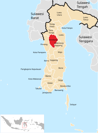
Enrekang Regency is an inland regency of South Sulawesi Province of Indonesia. It covers an area of 1,821.53 km2 and had a population of 190,175 at the 2010 census and 225,172 at the 2020 census; the official estimate as at mid 2023 was 231,301. The principal town lies at Enrekang.

Luwu Regency is a regency of South Sulawesi Province, Indonesia. The northern districts of the original regency were split off on 20 April 1999 to form a separate North Luwu Regency, and the former capital (Palopo) was split off to become an independent municipality (city) on 10 April 2002. The residual Luwu Regency now covers a land area of 3,000.25 km2 and had a population of 287,472 at the 2010 census and 365,608 at the 2020 census. The official estimate as at mid 2023 was 380,679. The administrative capital now lies at Belopa.
Kalegowa Stadium is a multi-use stadium in Pallangga, Gowa Regency, South Sulawesi, Indonesia. It is currently used mostly for football matches and is used as the home stadium for Persigowa Gowa

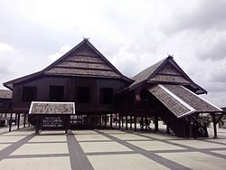
Somba Opu is a district (kecamatan) located in the Gowa Regency, South Sulawesi, Indonesia, and is part of the Greater Makassar area. Somba Opu is one of 18 districts in Gowa Regency. The administrative capital of Gowa Regency, "Sungguminasa", is located in this district and this is the largest regency capital or 2nd largest town in South Sulawesi. A suburb to Makassar, the district is a relatively urbanized area, and can also be called as the city's bedroom community.
On 22 January 2019, floods caused by heavy rainfall struck the Indonesian province of South Sulawesi. At least 68 people were killed and thousands were displaced. Gowa Regency was particularly hard-hit, experiencing the majority of the fatalities.
Kanreapia is a village in Tombolo Pao district, Gowa Regency in South Sulawesi province, Indonesia. Its population is 4304.