
Washington is a rural town in Litchfield County, Connecticut, in the New England region of the United States. The population was 3,646 at the 2020 census. Washington is known for its picturesque countryside, historic architecture, and active civic and cultural life. The town has strong ties to New York City, and is home to many cultural and business elites. The town is part of the Northwest Hills Planning Region.

Green Springs National Historic Landmark District is a national historic district in Louisa County, Virginia noted for its concentration of fine rural manor houses and related buildings in an intact agricultural landscape. The district comprises 14,000 acres (5,700 ha) of fertile land, contrasting with the more typical poor soil and scrub pinelands surrounding it.

Litchfield Historic District, in Litchfield, Connecticut, is a National Historic Landmark District designated in 1968 as a notable and well-preserved example of a typical late 18th century New England village. As a National Historic Landmark, it is listed on the National Register of Historic Places (NRHP). It is the core area of a larger NRHP-listed historic district that includes the entire borough of Litchfield and was designated a state historic district in 1959.

The Worthington Ridge Historic District encompasses the historic town center of Berlin, Connecticut. It runs mostly along Worthington Ridge Road from the intersection of Mill Street to Sunset Lane. This section of road was historically part of the Boston Post Road laid out in 1673, and is now lined by a diversity of residential architecture and several of the town's civic buildings. In 1974, the Berlin Historic District was formed in order to preserve the integrity of the architecture of the village. The district was listed on the National Register of Historic Places in 1989.

The Flanders Historic District is a historic district that encompasses a small cluster of late-18th to early-19th century residential structures north of the center of Kent, Connecticut, which was the original heart of the community when it was first settled. It is centered at the junction of United States Route 7 with Cobble Road and Studio Hill Road. The area was supplanted by the current town center in the 1840s. The district was listed on the National Register of Historic Places in 1979.

The Hotchkissville Historic District is a historic district in the town of Woodbury, Connecticut, that was listed on the National Register of Historic Places in 1995. The district encompasses most of the historic village of Hotchkissville, which is centered at the junction of Washington and Weekeepeemee roads. The village began as a dispersed rural agricultural community, but developed in the 19th century with the arrival of industry, primarily the manufacture of textiles. Despite this, the village has retained a significantly rural character, and includes a broad cross-section of 18th- and 19th-century architectural styles.
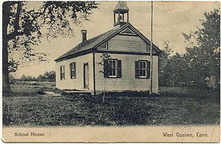
The West Goshen Historic District is a historic district in the village of West Goshen in the town of Goshen, Connecticut. It encompasses a well-preserved early 19th-century industrial village, with twenty historically significant properties in the village, most of which lie on Connecticut Route 4 between Beach Street and Thompson Road. The district was listed on the National Register of Historic Places in 1987.

The East Plymouth Historic District is a historic district in the town of Plymouth, Connecticut. It encompasses a small rural village in the northeastern part of the town, whose main focus is the 1792 St. Matthew's Church, one of the oldest surviving Episcopal church buildings in the state. The district runs along East Plymouth Road on either side of its junction with Marsh Road, and includes predominantly Greek Revival residential buildings erected in the early to mid-19th century. The district was listed on the National Register of Historic Places in 1985.

The Main Street Historic District encompasses the historic civic, commercial, and residential center of Durham, Connecticut. The district is primarily linear and runs along Main Street from between Higganum Road and Town House Road in the south to Talcott Lane in the north, and along Maple Avenue, which parallels Main Street. The district includes most of its colonial architecture, as well as many of its civic buildings. It was listed on the National Register of Historic Places in 1986.

The Torringford Street Historic District is a historic district on the east side of the city of Torrington, Connecticut. The district includes properties along Torringford Street, the main thoroughfare of the Torringford section of the city, between United States Route 202 and West Hill Road. The road is one of the oldest in Torrington, and this section is notable for containing a cross-section of well-preserved architecture from the 18th to the mid-20th centuries. The district was listed on the National Register of Historic Places in 1991.
Marion is a neighborhood in the town of Southington, Connecticut. It is generally the area in the vicinity of the intersection of Route 322 and Marion Avenue just north of the Cheshire town line.
The Bethlehem Green Historic District is a historic district in the center of the town of Bethlehem, Connecticut, listed on the National Register of Historic Places in 1982 for the architectural significance of the houses around the town green. The historic district includes the green and 63 contributing properties over an area of 55 acres (22 ha).

March Route of Rochambeau's Army: Plainfield Pike is a 3.6 mile-long road segment in Plainfield and Sterling, Connecticut which forms a portion of the historic march route of Comte de Rochambeau's army in June 1781 on its way to Yorktown, Virginia, and again of the returning army in November 1782. It was listed on the National Register of Historic Places (NRHP) in 2003.

The New Preston Hill Historic District encompasses a small rural 19th-century village center in the New Preston area of the town of Washington, in Litchfield County, Connecticut. Settled in the late 18th century, it is distinctive for its examples of stone architecture, include a rare Federal period stone church. The district, located at the junction of New Preston Road with Gunn Hill and Findlay Roads, was listed on the National Register of Historic Places in 1985.

The Kettle Creek Historic District encompasses one of the earliest settlement areas of the town of Weston, Connecticut. It consists of a small crossroads village center, extending north from the junction of Weston Road and Broad Street to the junction with Old Weston Road, and includes a small number of well-preserved 18th and 19th-century houses. It was listed on the National Register of Historic Places in 1985.

Fitzgerald Station and Farmstead is a collection of historic buildings and structures in Springdale, Arkansas associated with the Butterfield Overland Mail Trail. Historically the site of a tavern popular with travelers heading west prior to the establishment of the Butterfield Trail, the property became a station along the route in the 1850s. Today, the property retains an original 1850s barn built as a waypoint along the route, as well as an 1870s house and associated outbuildings. It was listed on the National Register of Historic Places in May 2003.

The Captain William Bull Tavern is a historic inn at 571 Torrington Road in Litchfield, Connecticut. It is part of the Tollgate Hill Inn and Restaurant, and is listed on the National Register of Historic Places. It is significant both as an excellent local example of Colonial architecture, and for its role in early architectural preservation efforts in the region.

The Hollister Homestead is a historic house at 300 Nettleton Hollow Road in Washington, Connecticut. Built about 1770, it is a prominent local example of Georgian architecture. The property is also the site of the Hollister House Garden, an English garden begun in 1979 and open to the public. The property was listed on the National Register of Historic Places in 2010. The gardens are open between May and October.

The Phelps Farm Historic District encompasses a collection of farm and residential properties on Connecticut Route 183 and Prock Hill Road in Colebrook, Connecticut. This area is a virtually intact mid-19th century farmstead, with its land under a single family's ownership since the 18th century. The district was listed on the National Register of Historic Places in 1983.


