 Old logo of the Survey of India
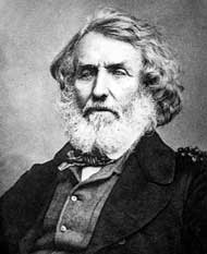
 Radhanath Sikdar, a mathematician who first calculated the height of Mount Everest in 1852.
| | |
 | |
| Survey and mapping agency overview | |
|---|---|
| Formed | 1767 [1] |
| Jurisdiction | Government of India |
| Headquarters | Hathibarkala Estate, New Cantt Road, Dehradun, Uttarakhand, India [2] |
| Employees | 5,500 (2016) [3] |
| Minister responsible | |
| Survey and mapping agency executive |
|
| Parent department | Department of Science and Technology |
| Website | surveyofindia |

The Survey of India is India's central engineering agency in charge of mapping and surveying. [4] Set up in 1767 [5] to help consolidate the territories of the British East India Company, it is one of the oldest Engineering Departments of the Government of India. Its members are from Survey of India Service cadre of Civil Services of India. It is headed by the Surveyor General of India. At present, the Surveyor General is Hitesh Kumar S. Makwana.


