
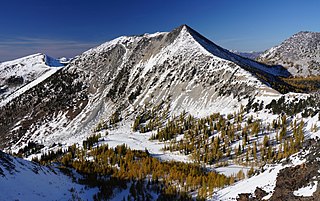
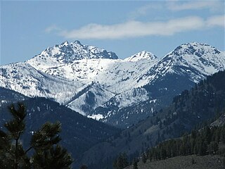
Big Kangaroo is an 8,326-foot (2,538-metre) mountain summit in Okanogan County, Washington, United States.

The Needles is an 8,160-foot (2,487-metre) granite mountain located in Okanogan County in Washington state. It is part of the Okanogan Range which is a sub-range of the North Cascades Range. The Needles is situated on land administered by the Okanogan–Wenatchee National Forest. Precipitation runoff from the peak drains into tributaries of the Methow River. Topographic relief is significant as the summit rises 3,660 feet above Pine Creek in approximately 1.25 mile (2 km). The nearest higher neighbor is Tower Mountain, 2.26 miles (3.64 km) to the southwest.

Gilbert Mountain is an 8,023-foot (2,445-metre) massif located in Okanogan County in Washington state. It is part of the Methow Mountains which are a subrange of the North Cascades. The mountain is situated within the Lake Chelan-Sawtooth Wilderness which is managed by Okanogan–Wenatchee National Forest. The northwestern extreme of the Gilbert massif connects to the southern end of Kangaroo Ridge. Precipitation runoff from the mountain drains into the Twisp River. Topographic relief is significant as it rises over 4,000 feet above the river in approximately one mile.

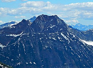
Azurite Peak is an 8,434-foot (2,571-metre) double-summit mountain located at the common boundary point of Okanogan County, Skagit County, and Whatcom County in Washington state. It is part of the Okanogan Range which is a sub-range of the North Cascades Range. Azurite Peak ranks as the 81st-highest summit in the state. Azurite Peak is situated north of Azurite Pass on land administered by the Okanogan–Wenatchee National Forest. The nearest higher neighbor is Tower Mountain, 5.24 miles (8.43 km) to the south-southeast, and Mount Ballard lies 1.97 miles (3.17 km) to the north. Remnants of a small pocket glacier are found on the east aspect. Precipitation runoff from the peak drains north into tributaries of the Skagit River, and south into the Methow River. Topographic relief is significant as the summit rises over 3,000 feet above Mill Creek in one mile (1.6 km). The Pacific Crest Trail traverses the base of Azurite Peak.

Snagtooth Ridge is a jagged granitic ridge located in Okanogan County of Washington state. It is part of the Methow Mountains which are a subrange of the North Cascades. Snagtooth Ridge is situated between Silver Star Mountain and Kangaroo Ridge on land administered by the Okanogan–Wenatchee National Forest. Precipitation runoff from the ridge drains into tributaries of the Methow River. Topographic relief is significant as the summit rises approximately 3,000 feet above West Fork Cedar Creek in one mile (1.6 km).

Delancy Ridge is a four-mile-long ridge located in Okanogan County of Washington state. It is part of the Okanogan Range which is a sub-range of the North Cascades. Delancy Ridge is situated east of The Needles on land administered by the Okanogan–Wenatchee National Forest. Delancy Ridge can be seen from Washington Pass and from the North Cascades Highway which follows the length of its southern base. Precipitation runoff from the north side of the ridge drains into the Methow River, whereas the south side drains into Early Winters Creek which is a tributary of the Methow River. This landform's toponym was officially adopted in 1978 by the United States Board on Geographic Names.

Stiletto Peak is a 7,660 ft summit located in the Methow Mountains, a sub-range of the North Cascades in Washington state. It is situated in the Stephen Mather Wilderness on a ridge which also has Switchblade Peak and Jackknife Peak to its east. Stiletto Peak is also located on the boundary of North Cascades National Park, 2.24 miles (3.60 km) due north of Hock Mountain. Precipitation runoff on the north side of the mountain drains to Bridge Creek via Copper Creek, whereas the south side of the mountain drains into the East Fork Bridge Creek.

Copper Benchmark, also known as Copper Point, is a 7,844-foot-elevation (2,391-meter) mountain summit located on the shared border between Okanogan County and Chelan County in Washington state. Copper Benchmark is part of the Methow Mountains which are a subrange of the North Cascades, and it is situated on the crest of the Cascade Range between Kangaroo Pass and Copper Pass. It was used as a triangulation station for early surveying. It is protected by the Lake Chelan-Sawtooth Wilderness within the Okanogan–Wenatchee National Forest. Copper Benchmark has a subsidiary peak, Pica Peak (elevation 7,565 feet, which is 0.52 miles northwest of the summit. The nearest higher peak is Wallaby Peak, 0.9 miles to the northeast. Precipitation runoff on the north side of the mountain drains to the Methow River via Early Winters Creek, whereas the other sides of the mountain drain into tributaries of the Chelan River.

Star Peak is an 8,693-foot (2,650-metre) mountain summit located in the Methow Mountains, a sub-range of the North Cascades in Washington state. The peak is the highest point on Sawtooth Ridge, and the 35th-highest peak in the state. The nearest higher peak is Oval Peak, 2.52 miles (4.06 km) to the north. It is protected by the Lake Chelan-Sawtooth Wilderness within the Okanogan–Wenatchee National Forest. Precipitation runoff on the south side of the mountain drains into Lake Chelan via Prince Creek, whereas the north side of the mountain drains into Buttermilk Creek which is a tributary of the Twisp River.

Monument Peak is an 8,597-foot (2,620-metre) mountain summit located in western Okanogan County in Washington state. It is part of the Okanogan Range which is a sub-range of the North Cascades. The mountain is situated in the Pasayten Wilderness, on land administered by the Okanogan–Wenatchee National Forest. The nearest higher peak is Mount Lago, 2.42 miles (3.89 km) to the north. Precipitation runoff from Monument Peak drains east into Monument Creek, and west into Eureka Creek, which are both part of the Methow River drainage basin. Topographic relief is significant as the summit rises 3,800 feet above Eureka Creek in 1.25 mile (2 km).

Windy Peak is an 8,335-foot (2,541-metre) mountain summit located in Okanogan County in Washington state. It is part of the Okanogan Range which is a sub-range of the North Cascades and Cascade Range. The mountain is situated five miles (8.0 km) south of the Canada–United States border, on the east side of the Cascade crest, in the Pasayten Wilderness, on land managed by the Okanogan–Wenatchee National Forest. The nearest higher peak is Haystack Mountain, 9.24 miles (14.87 km) to the northwest in Canada. Precipitation runoff from Windy Peak drains into tributaries of the Methow River and Similkameen River.

Wallaby Peak is a 7,995-foot (2,437-metre) mountain summit located on the boundary line of the Lake Chelan-Sawtooth Wilderness, in Okanogan County, Washington. The mountain is part of the Methow Mountains, which are a subset of the Cascade Range. Wallaby Peak is situated on Kangaroo Ridge which is approximately two miles east and within view of Washington Pass. The nearest higher peak is Big Kangaroo, 0.86 mi (1.38 km) to the north. Precipitation runoff from the peak drains into Early Winters Creek, Cedar Creek, and North Fork Twisp River, all of which are tributaries of the Methow River.
Courtney Peak is an 8,394-foot (2,558-metre) mountain summit located in the Methow Mountains which are a sub-range of the North Cascades in Washington state. Situated on Sawtooth Ridge, Courtney Peak is part of the Lake Chelan-Sawtooth Wilderness, a protected area within the Okanogan–Wenatchee National Forest. Courtney Peak ranks 80th on Washington's highest 100 peaks, and 81st on the "Bulger List". The nearest higher peak is Star Peak, 0.83 miles (1.34 km) to the southeast. Precipitation runoff on the west side of the mountain drains into nearby Lake Chelan via Fish Creek, whereas the north side of the mountain drains into Oval Creek, and the east side drains into Buttermilk Creek, both of which are tributaries of the Twisp River. The mountain's name was officially adopted in 1985 to remember James (Ray) Courtney (1920-1982), a commercial packer and lifelong resident of Stehekin. The immediate vicinity of this peak was a favorite destination for his guided outings. Ray Courtney died in an accident while leading such a pack trip with 29 hikers when the horse he was riding lost its footing and fell down a gully.

Gray Peak is an 8,086-foot (2,465-metre) mountain summit located in the Methow Mountains, a sub-range of the North Cascades in Washington state. Situated on Sawtooth Ridge, west of Oval Lakes, Gray Peak is protected by the Lake Chelan-Sawtooth Wilderness within the Okanogan–Wenatchee National Forest. The nearest higher peak is Courtney Peak, 1.07 miles (1.72 km) to the southeast. Precipitation runoff on the south side of the mountain drains into nearby Lake Chelan via Fish Creek, whereas the north side of the mountain drains into Oval Creek, which is a tributary of the Twisp River.

Martin Peak is an 8,377-foot (2,553-metre) mountain summit located in the Methow Mountains, a subset of the North Cascades in Washington state. It is the seventh-highest peak in the Methow Mountains, and ranks 80th in the state of Washington. Martin Peak is set on Sawtooth Ridge, at the head of Martin Creek, on land managed by the Okanogan-Wenatchee National Forest. Other peaks of Sawtooth Ridge include Oval Peak, Star Peak, Hoodoo Peak, Courtney Peak, Switchback Peak, and Mount Bigelow, which is the nearest higher neighbor, 2.06 miles (3.32 km) to the north of Martin.
Lost Peak is an 8,464-foot (2,580-metre) mountain summit located in western Okanogan County in Washington state. It is part of the Okanogan Range which is a subset of the North Cascades. This remote mountain is situated 16 mi (26 km) north of Mazama, and 7 mi (11 km) northwest of Big Craggy Peak. It is set in the Pasayten Wilderness, on land administered by the Okanogan–Wenatchee National Forest. Lost Peak ranks 62nd of Washington's highest 100 peaks, and 63rd on the "Bulger List". Precipitation runoff from Lost Peak drains into tributaries of Lost River, which in turn is part of the Methow River drainage basin.
Hock Mountain is a 7,750-foot-elevation summit located in the Methow Mountains which are a subset of the North Cascades in Washington state. It is situated on the triple-shared boundary of North Cascades National Park, Lake Chelan-Sawtooth Wilderness, and Lake Chelan National Recreation Area, as well as the shared border between Chelan County and Okanogan County. Additionally, it lies one mile southwest of Twisp Mountain, and 2.24 miles (3.60 km) due south of Stiletto Peak, the nearest higher neighbor. The north face is steep, granitic rock, but the west slope is more moderate, allowing a scramble ascent. Precipitation runoff from the north and west sides of Hock drains to the Stehekin River via Bridge Creek, whereas the south and east sides of the mountain drain into the South Fork Twisp River.
Mother Lode is a 7,905-foot-elevation (2,409-meter) mountain summit located in the North Cascades, in Okanogan County, Washington. It is situated in the Lake Chelan-Sawtooth Wilderness, on land managed by Okanogan–Wenatchee National Forest. The mountain is part of the Methow Mountains, which are a subset of the Cascade Range, and the peak is approximately two miles east of the crest of the range. Mother Lode is set approximately six miles south of Washington Pass, and the nearest higher neighbor is Gilbert Mountain, three miles to the northeast. Topographic relief is significant as the north aspect rises 3,500 feet above the South Fork Twisp River in one mile. The peak was climbed in 1983 by Rick La Belle and Glen Sterr via the north ridge, and the northeast ridge was climbed in 1985 by Carl and Gordon Skoog. Precipitation runoff from the peak drains into tributaries of Twisp River, which in turn is a tributary of the Methow River.
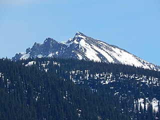
Gardner Mountain is an 8,898-foot-elevation (2,712-meter) mountain summit in Okanogan County of Washington state.
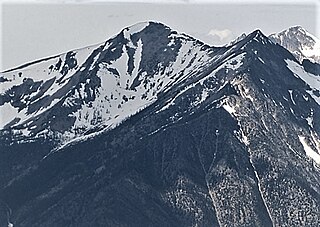
Mount Bigelow is an 8,449-foot-elevation (2,575-meter) mountain summit located on the border shared by Okanogan and Chelan counties in Washington state.


